
"THE GREAT SAUK TRAIL" ~ Amherstburg
N 42° 06.180 W 083° 06.785
17T E 325277 N 4663372
This plaque is located in the King's Navy Yard Park at Dalhousie Street in Amherstburg.
Waymark Code: WM9B99
Location: Ontario, Canada
Date Posted: 07/26/2010
Views: 7
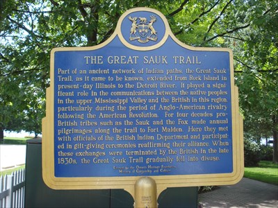
THE GREAT SAUK TRAIL
Part of an ancient network of Indian paths, the Great Sauk Trail, as it came to be known, extended from Rock Island in present-day Illinois to the Detroit River. It played a significant role in the communications between the native peoples in the upper Mississippi Valley and the British in this region, particularly during the period of Anglo-American rivalry following the American Revolution. For four decades pro-British tribes such as the Sauk and the Fox made annual pilgrimages along the trail to Fort Malden. Here they met with officials of the British Indian Department and participated in gift-giving ceremonies reaffirming their alliance. When these exchanges were terminated by the British in the late 1830s, the Great Sauk Trail gradually fell into disuse.
Historical Significance of Amherstburg
One of the oldest towns in Ontario, Amherstburg’s roots are unparalleled in Essex County. This was the center stage during the War of 1812, providing the British forces with a vital garrison and an important ship building port. Equal in size to Detroit in 1830, it provided a home for former slaves as one of the important stations on the Underground Railway. It also served as the front line during the bootlegging years.
Amherstburg is the endpoint of the Great Sauk Trail. Between the late eighteenth century and 1839 the Sauk, Fox, Winnebago, Miami, Potawatomi and other tribes made their annual pilgrimage to Amherstburg to receive presents from the British Government. The trail started where the Rock River met the Mississippi, through Illinois, Indiana and Michigan. They crossed near Detroit and followed the river to Amherstburg, where the presents were distributed by the British Indian Agent at the Matthew Elliott home about two miles to the south of town.
Information taken from: Visit website