Noted Indian Trail-GHM-099-1-Meriwether County
Posted by: Groundspeak Regular Member Sprinterman
N 33° 04.147 W 084° 34.315
16S E 726672 N 3661570
Ga 85 about 1.8 miles southeast of Gay
Waymark Code: WM4Q0X
Location: Georgia, United States
Date Posted: 09/17/2008
Published By:Groundspeak Regular Member Lat34North
Views: 15

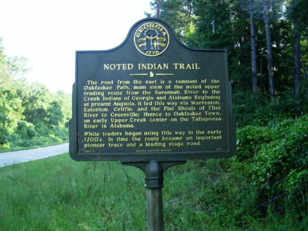
The road from the east is a remnant of the Oakfuskee Path, main stem of the noted upper trading route from the Savannah River to the Creek Indians of Georgia and Alabama[.] Beginning at present Augusta, it led this way via Warrenton, Eatonton, Griffin, and the Flat Shoals of Flint River to Greenville; thence to Oakfuskee Town, an early Upper Creek center on the Tallapoosa River in Alabama. White traders began using this way in the early 1700's. In time the route became an important pioneer trace and a leading stage road.
Type of Marker: Highway

Marker #: 099-1

Date: 1993

Sponsor: Not listed

Visit Instructions:
Take a picture of the marker, yourself at the marker, your gps at the marker, or anything specific to the text on the marker. And don't forget to enjoy your visit.
Search for...
Geocaching.com Google Map
Google Maps
MapQuest
Bing Maps
Nearest Waymarks
Nearest Georgia Historical Markers
Nearest Geocaches
Create a scavenger hunt using this waymark as the center point
Recent Visits/Logs:
Date Logged Log User Rating  
mrahudson visited Noted Indian Trail-GHM-099-1-Meriwether County 09/02/2017 mrahudson visited it
Sprinterman visited Noted Indian Trail-GHM-099-1-Meriwether County 09/07/2008 Sprinterman visited it

View all visits/logs