 |
Marker Text:
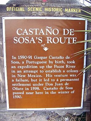
Castaño de Sosa’s Route
In 1590-91 Gaspar Castaño de Sosa, a Portuguese by birth, took an expedition up the Pecos River in an attempt to establish a colony in New Mexico. His venture was a failure, but it led to a permanent settlement under Don Juan de Onate in 1598. Castaño de Sosa passed near here in winter of 1590, as he pushed north along the Pecos River, the group passed along this route in the vicinity of present-day Artesia and Roswell.
|