If you drive too fast you'll miss it. Along Hwy 273 which was once Old Siskiyou Hwy 99 is a painted yellow 'T' Marker, one of many you may find throughout Southern Oregon and Northern California. These markers highlight historic locations that were once emigrant trails or roads used by Indians, settlers and travelers from one community to another.
This particular marker highlights the Siskiyou Mountain Wagon Road which existed along this stretch of highway. I discovered a newspaper article from 2007 in the Medford Mail Tribune that gave more information regarding this historic road and reads:
October 21, 2007
By Bill Miller for the Mail Tribune
If you blink, you're going to miss it. It doesn't matter how slowly you drive down the six miles of Old Highway 99, east of Ashland.
Except for a few old-timers and some families still living alongside the old thoroughfare, the historic marker, just downhill from the Siskiyou Summit, has pretty much been forgotten.
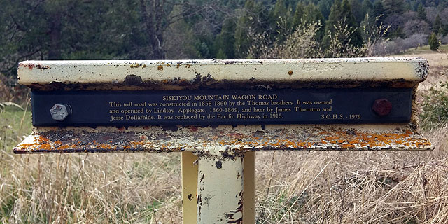
Placed by the Southern Oregon Historical Society's Trail Committee nearly 30 years ago, the rectangular brown metal sign stands in a field barely 5 feet west of the pavement.
During the summer, it's difficult to find, camouflaged behind the tall grasses that grow in the meadow. By winter, the grasses recede but winter snows are likely to bury the marker until late spring.
Although the road probably began as an American Indian trail between California and Oregon, this marker commemorates the Siskiyou Mountain Wagon Road, constructed 1858-60.
It was a toll road owned and operated by Lindsay Applegate until 1869, and later by James Thornton and Jesse Dollarhide.
Mark E. Lawrence, a key member of the SOHS Trail Committee, compiled information on the road for a 1982 report.
"Road construction was largely by hand with the aid of slip scrapers," he wrote. "This resulted in roads which often took circuitous routes to avoid serious obstacles, sticky bottoms and Indian encampments."
Although the road and grade were realigned and straightened numerous times over the route's 150-year history, you'll probably not believe it. A drive today along its steep and narrow twists and turns is sure to give you a taste of an 1860s stagecoach ride, without the swirling dust.
Though nothing is left, the actual location of the old toll station is about an eighth of a mile south of the wagon road marker. That site is now on private property and not available for inspection.
As the marker will tell you, the Pacific Highway replaced the toll road in 1915.
Jackson County voters had approved a half-million dollar bond issue to improve the road as part of a statewide plan with the motto, "Get Oregon Out of the Mud."
Historic preservationist George Kramer wrote a history of the highway in a 1995 article for the SOHS publication, "Oregon Heritage."
"The much-lauded Siskiyou Highway — although wide and gently graded — was still just a dirt road," he said.
"By 1921," he continued, "Jackson County was one of the first counties along the Pacific Highway offering a continuously paved surface from county line to county line."
In 1945, the state highway commission designated the Pacific Highway as Oregon's "official inter-regional north-south route through Oregon." It was all part of a projected system of national highways.
With federal involvement, the road was designated Highway 99, a name that had been growing in popularity.
Interstate 5 completely replaced the old highway by 1967, leaving it in bits and pieces across the state, including that six-mile stretch, east of Ashland.
Drivers zipping over the Siskiyou Pass have no idea of the history they're passing by — the history of a road Kramer remembered as "Oregon's Main Street."
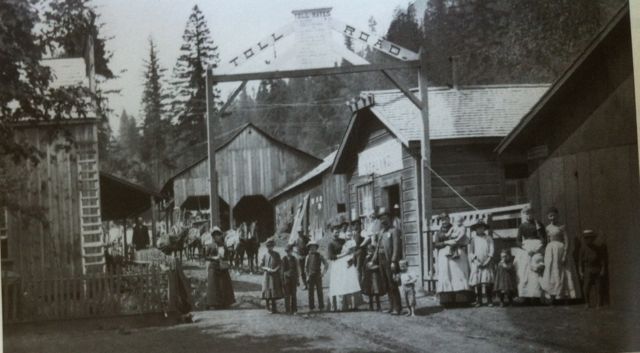
I could not locate any pertinent information on the Thomas brothers but there is lots of information on Lindsay Applegate, who is credited with creating the historic Applegate Trail which passed through this same road in 1846 into Oregon and ending in the Willamette Valley. Wikipedia has a good bio of Lindsay Applegate here. I was able to locate a website that contains a dairy from James Thornton here. James Thornton (1827-1922) was an early Wagner Creek settler and eventually settled in Ashland, OR (the same with Lindsay Applegate, who is buried in Ashland Cemetery, the oldest pioneer cemetery in the area). As for Jesse Dollarhide, I located a nice obituary from FindaGrave.com here (and from which the historic picture of the Toll Road came from) and there's a great writeup from a guest of the site that reads:
The Dollarhide Toll Road: Jesse and his sons purchased the right of way for a section of the Applegate Trail running from the foot of the mountains south of Ashland, Oregon across the Siskiyou Mountains summit and down to the village of Hornbrook, California. Although they had originally purchased the road for their own use, the roadway was to become a vital link and a primary wagon road between California and Oregon. As a family-operated toll road, it became a steady source of income to the Dollarhide family and they profited from it for some 30 years. The road was part of the same route which became the Pacific Highway, then U.S. Highway 99, and currently, Interstate 5. The Dollarhide family operated the road from 1885 to 1916, when they sold their right of way to the State of Oregon. Today, this section of Interstate 5 is still the highest and most challenging mountain pass between Canada and Mexico.