|
 Nicholas T. Delean Building - Yreka, CA
N 41° 43.900 W 122° 38.148
10T E 530288 N 4620048
This historical marker is located at the Nicholas T. Delean Building on corner of Miner Street and Main St (Hwy3) in downtown Yreka, CA.
Waymark Code: WMH452
Location: California, United States
Date Posted: 05/19/2013
Views: 3
 This historical marker hangs in front of the Nicholas T. Delean Building on historic W Miner St. There are numerous older buildings along Miner Street that contain historical markers that relate the history of each building. This historic building's marker reads:
Nicholas T. Delean Building
102 W. Miner St.
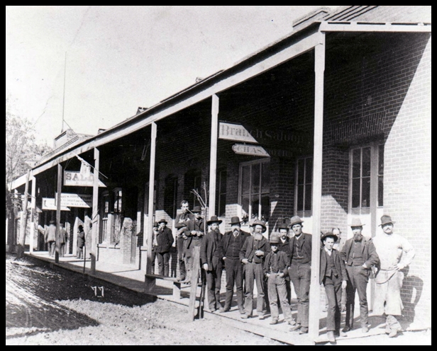
Jerome Churchill, packer, financier and entrepreneur raised a general merchandise store here in 1851. It was a tent. When several of these "temporary" structures continued to burn, Churchill put up a "fireproof" brick building in 1855. The devastating inferno of 1871, however, also devastated Mr. Churchill when this structure was destroyed, but he rebuilt once again and the building served many business endeavors through the years. When the State of California mandated the widening of Main Street in 1934, the building was leveled, but a new concrete structure was erected by N.T. Delean, a tailor, who operated a business next door. Later, a restaurant and several bars served the public in this building. |
I located a nice article on the history of the Churchill building before it burned down in 1871 and contains the picture of the building (above) here.
Yreka has a few websites devoted to preserving its rich history. Siskiyouhistory.org is a good place to start and breaks up the town's history into groups of years. Yrekapreservation.org contains some nice pictures of original homes and commercial buildings from yesteryear. Finally, Yrekahistory.blogspot.com is a good blog website which contains great stories and events of Yreka's past and all their articles have been archived.
Type of Structure: Private Building

Construction Date: 01/01/1855
Fire Date: 07/04/1871
Structure status: Gutted building
Cause of Fire:
On July 4th, 1871, disaster struck — a fire burned down a good portion of the town, including most of the business district (the cause was most likely from fireworks). But the town came together and rebuilt, stronger (and more fire-proof) than before.
Documentation of the fire: [Web Link]
Other: Not listed
|
Visit Instructions:
Give a narrative of your experience. Did you learn anything after reading about the fire in the waymark? Photos are always welcome too. Please no virtual visits.
Recent Visits/Logs:
| There are no logs for this waymark yet. |
|
|
|
|