
Rosecrans' Headquarters Shell Monument - Chickamauga National Military Park
Posted by:  Lat34North
N 34° 54.949 W 085° 16.314
16S E 657861 N 3865070
This pyramid of cannon balls marks the location of Rosecrans' Headquarters from 10 a.m. to 11:15 a.m. on Sept. 20, 1863. It is located in Dyer’s Field, south of Dyer Rd and east of Vittetoe-Chickamauga Rd in the Chickamauga National Military Park.
Waymark Code: WMDT40
Location: Georgia, United States
Date Posted: 02/21/2012
Views: 1
This pyramid of cannon balls marks the location of Major General
William Starke Rosecrans Headquarters on September 20, 1863, from 10 a.m. to 11:15 a.m. during the
Battle of Chickamauga, fought September 19–20, 1863. Rosecrans took command of the
Army of the Cumberland on October 24, 1862.
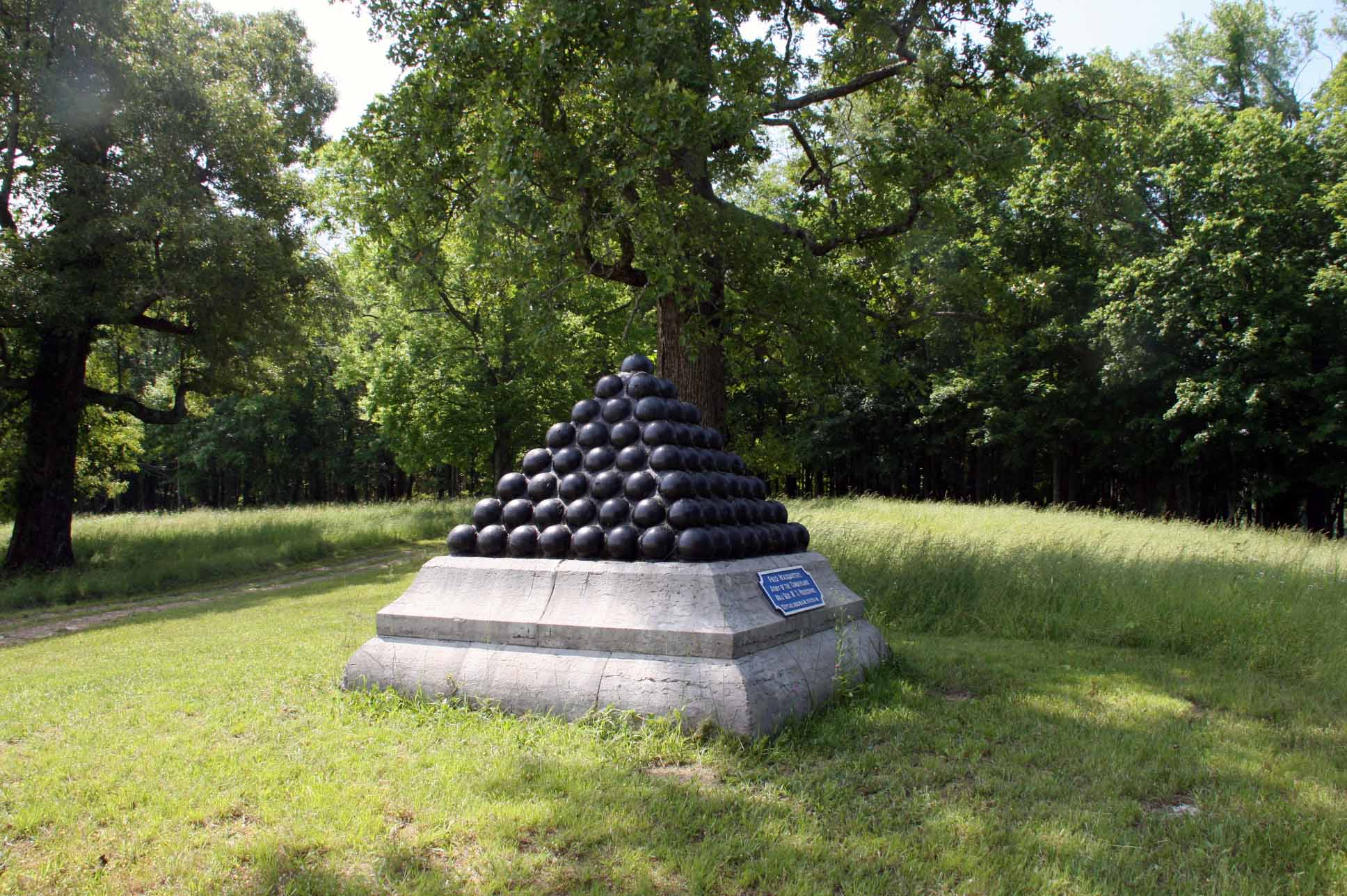
Text on the front of the monument:
Field Headquarters
Army of the Cumberland
Maj. Gen. W. S. Rosecrans
Sept. 20, 1863, 10 A.M. to 11:15 AM
From the NRHP nomination form:
| |
Structure Number: |
MT-451(see note) |
| |
LCS ID: |
003257 |
Historical Significance:
| |
National Register Status:
|
Entered - Documented
|
| |
National Register Date:
|
10/15/1966
|
| |
National Historic Landmark?: |
No
|
| |
Significance Level:
|
Contributing
|
| |
Short Significance Description:
|
The marker contributes to the national significance of the park under NR Criterion A because it represents the national movement among veterans to commemorate Civil War battlefields. This was the first U.S. national military park.
|
Short Physical Description
7'10" square at base and 5' high, the monument consists of a pyramid of cannonballs set in cement & painted black, resting on a molded limestone base. Attached to base is a painted metal plaque identifying the headquarters site.
Long Physical Description
The cannonballs were originally welded together, and then later laid with cement in the corners of the monument--vandals occasionally try to chip out the balls (2000 assessment).
Monument located within the Chickamauga Battlefield at map site #185.
Material(s)
|
|
Structural Component(s)
|
Material(s)
|
1.
|
Superstructure
|
Limestone
|
2.
|
Substructure
|
Concrete
|
3.
|
Superstructure
|
Iron
|
4.
|
Substructure
|
Concrete
|
|
Construction Period:
|
Historic
|
Chronology:
|
|
Physical Event
|
Begin Year
|
Begin Year AD/BC
|
End Year
|
End Year AD/BC
|
Designer
|
Designer Occupation
|
1.
|
Built
|
1893
|
AD
|
1895
|
AD
|
Betts, E. E.
|
Engineer
|
2.
|
Rehabilitated
|
2008
|
AD
|
2008
|
AD
|
|
|
|
|
My Sources
1.
NRHP
2. Wikipedia -
Battle of Chickamauga
3. The Civil War Home -
The Chickamauga Campaign - Union Order of Battle
4. Wikipedia -
William Starke Rosecrans
5. Wikipedia -
Army of the Cumberland
Note
Trailhead Graphics, Inc. has produced a map of the Chickamauga Battlefield showing the locations of all of the monuments and the markers on the battlefield. Each location on the map has a number associated with it that cross-references to an index on the back of the map that has the name of the marker (called the Chick-Chatt NMP monument numbering system). This number corresponds to the structure Number listed on the NPS List of Classified Structures that is normally prefixed with the letters MT for the Chickamauga Battlefield.