
Cape Cove Trail - Oregon
Posted by:  silverquill
N 44° 16.896 W 124° 06.547
10T E 411499 N 4903748
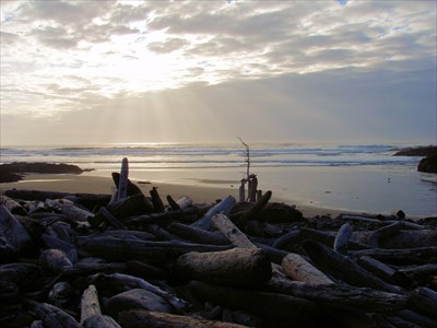
Cape Cove Trail is a 0.3 mile trail descending from the bluff to the beach about 75 feet below where Cape Creek meets the Pacific Ocean. There are connections here to other trails to the north and south.
Waymark Code: WMBA2X
Location: Oregon, United States
Date Posted: 04/25/2011
Views: 2
Like many small creeks along the Oregon coast, Cape Creek flows from the the mountains to the east. Here Cape Perpetua, the highest point on the Oregon coast rising some 800 feet, thrusts out into the Pacific Ocean. On the north side the 12-mile Yachats River has its destination, and this smaller creek joins the ocean on the south side.
There are several creeks on the Oregon coast bearing the name "Cape Creek," and the best known of these is further south where it joins the ocean just south of Haceta Head, with its famous lighthouse, and is spanned by the stunning Cape Creek Bridge at Devil's Elbow.
This creek passes through the Cape Perpetua Campground, then passes through a culvert under the scenic Coast Highway, U.S. 101, and through piles of drift logs, then hugging the lava rocks on its northern bank as it enters the Pacific Ocean.
The small beach here is perfect for relaxation while listening to the surf without the crowds of people. The Cape Cove Trail follows the rocks to the south connecting to Captain Cook's Trail which can be traversed all the way to Cook's Chasm, with many excellent places to hunt for agates and explore tide pools. The trail north leads through sitka spruce, over the rocks connecting with The Trail of the Restless Waters which is a loop trail leading to Devil's Churn.
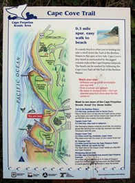
So, there are several ways to access the mouth of Cape Creek. The easiest access is via this trail that leads from a classic wind-swept sitka spruce down a winding trail through salal bushes on the south-bound side of U.S. 101, where there is a small unpaved parking area at the trail head.
The second common access is from the trail that starts at Devil's Churn to the north where there is a larger paved parking area with facilities and a visitors center. Access from the south is possible from the Cook's Chasm viewpoint and Captain Cook's Trailhead where there is now ample parking. It is even possible, for the adventuresome, to reach here from the Cape Perpetua Campground by wading along the creek and through the culvert, then scrambling over the drift logs.