 view gallery view gallery SE44.1 km SE44.1 km
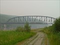
|   Mears Memorial Bridge -- Nenana, AK Mears Memorial Bridge -- Nenana, AK
in Truss Bridges Mears Memorial Bridge crosses the Tanana River at Nenana, AK. posted by:  wilsonjw wilsonjw location: Alaska date approved: 10/11/2017 last visited: 12/31/2022 |
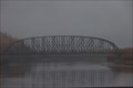 view gallery view gallerySE44.1 km |  Mears Memorial Bridge -- Nenana, AK USA Mears Memorial Bridge -- Nenana, AK USA
in Wikipedia Entries The Mears Memorial Bridge was inaugurated in 1923 by Pres. Warren G Harding who drove a golden spike here, signifying the completion of the the Alaska Railroad. posted by: Benchmark Blasterz location: Alaska date approved: 12/01/2022 last visited: 01/30/2023 |
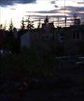
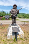 view gallery view gallerySE44.1 km |  Alaska Territorial Guard - Nenana, Alaska Alaska Territorial Guard - Nenana, Alaska
in Figurative Public Sculpture This statue commemorates the Alaska Territorial Guard, which helped with reconnaissance and defense in Alaska during World War II. It's located in a small park at the south end of Nenana, Alaska. posted by: The A-Team location: Alaska date approved: 10/19/2023 last visited: never |
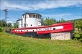 view gallery view gallerySE44.1 km |  Taku Chief - Nenana, Alaska Taku Chief - Nenana, Alaska
in Landlocked Boats The Taku Chief is a former tug that is now on display in a park at the south end of Nenana, Alaska. posted by: The A-Team location: Alaska date approved: 10/14/2023 last visited: never |
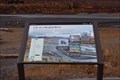
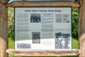 view gallery view gallerySE44.1 km |  Alaska Native Veterans' Honor Bridge - Nenana, AK Alaska Native Veterans' Honor Bridge - Nenana, AK
in Alaska Historic Markers This marker discusses the Alaska Natives who have served in the US Armed Forces, and the bridge to the north that was dedicated in their honour. The marker is located in a small park at the south end of Nenana, Alaska. posted by: The A-Team location: Alaska date approved: 10/19/2023 last visited: never |
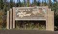 view gallery view gallery NE81.8 km NE81.8 km
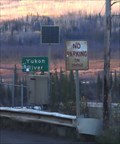
|  Welcome to the Dalton Highway -- Yukon-Koyukuk Borough, AK USA Welcome to the Dalton Highway -- Yukon-Koyukuk Borough, AK USA
in Artistic Welcome Signs This artistic welcome sign is a cheerful greeting on one of the world's most dangerous highways, the Dalton Highway posted by: Benchmark Blasterz location: Alaska date approved: 12/04/2022 last visited: 03/01/2023 |
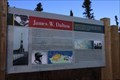 view gallery view galleryNE81.9 km | James W. Dalton -- Dalton Hwy pull-out, Yukon-Koyukuk Borough, AK USA in Alaska Historic Markers This historical marker is dedicated to James W Dalton, lifelong Alaskan and civil engineer whose knowledge of construction in permafrost environments on the North Slope opened northern Alaska for petroleum exploration and extraction posted by: Benchmark Blasterz location: Alaska date approved: 11/30/2022 last visited: 12/01/2022 |
 view gallery view galleryNE81.9 km |  START -- of the Dalton Hwy, AK SH 11, AK USA START -- of the Dalton Hwy, AK SH 11, AK USA
in First of its Kind The start of the famously dangerous Dalton Highway is where the AK SH 2 meets the AK SH 11 (The Dalton Hwy). Coordinates are at the metal sign posted by: Benchmark Blasterz location: Alaska date approved: 11/29/2022 last visited: 11/30/2022 |
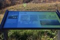 view gallery view gallery N88.5 km N88.5 km
|  Fire Sparks New Life -- Dalton Hwy MP 20.7, Yukon-Koyokuk Borough, AK USA Fire Sparks New Life -- Dalton Hwy MP 20.7, Yukon-Koyokuk Borough, AK USA
in Flora and Fauna Information Signs One of two flora and fauna information science at this new pullout at milepost 20.7 on the Dalton Highway posted by: Benchmark Blasterz location: Alaska date approved: 11/30/2022 last visited: 12/01/2022 |
 view gallery view galleryN88.5 km | Reading the Land -- Dalton Hwy MP 20.7, Yukon-Koyokuk Borough, AK USA in Flora and Fauna Information Signs Second of two flora and fauna information science at this new pullout at milepost 20.7 on the Dalton Highway posted by: Benchmark Blasterz location: Alaska date approved: 11/30/2022 last visited: 12/01/2022 |
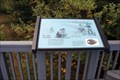
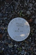 view gallery view galleryN88.5 km |  AK DOT/PF BM Dalton MP 20.7 -- Dalton Highway, Yukon-Koyokuk Borough, AK USA AK DOT/PF BM Dalton MP 20.7 -- Dalton Highway, Yukon-Koyokuk Borough, AK USA
in U.S. Benchmarks Benchmark placed by the state of Alaska Department of Transportation and Public Facilities, at the pullout/rest area at milepost 20.7 of the Dalton Highway. posted by: Benchmark Blasterz location: Alaska date approved: 11/30/2022 last visited: 12/01/2022 |
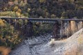
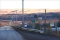 view gallery view galleryN110.6 km |  E. L. Patton Yukon River Bridge -- Dalton Hwy, Yukon-Koyokuk Borough, AK USA E. L. Patton Yukon River Bridge -- Dalton Hwy, Yukon-Koyokuk Borough, AK USA
in Plank Roads This bridge carrying the Dalton Highway over the Yukon River is made of planks, which are more durable than asphalt or concrete in this extreme Arctic environment posted by: Benchmark Blasterz location: Alaska date approved: 11/30/2022 last visited: 12/01/2022 |
 view gallery view galleryN110.6 km |  E. L. Patton Yukon River Bridge -- Dalton Hwy, Yukon-Koyokuk Borough, AK USA E. L. Patton Yukon River Bridge -- Dalton Hwy, Yukon-Koyokuk Borough, AK USA
in Solar Power A small solar array panel on the EL Patton bridge over the Yukon River powers lights on the bridge posted by: Benchmark Blasterz location: Alaska date approved: 11/30/2022 last visited: 12/01/2022 |
 view gallery view galleryN111.2 km |  Yukon River Camp Truck Stop -- Yukon-Koyukuk Borough, AK USA Yukon River Camp Truck Stop -- Yukon-Koyukuk Borough, AK USA
in Truck Stops There are a few places along the Dalton Highway to stop for food or fuel. The Yukon River Camp truck stop is the second of three places on this Arctic Highway to gas up posted by: Benchmark Blasterz location: Alaska date approved: 11/30/2022 last visited: 03/01/2023 |
 view gallery view gallery S117.2 km S117.2 km
|  Counting Display "Bottles Saved" -- 49th State Brewing Company, Healy, Denali Borough, AK USA Counting Display "Bottles Saved" -- 49th State Brewing Company, Healy, Denali Borough, AK USA
in Counting and Measuring Displays The Counting Display "Bottles Saved" at 49th State Brewing Company, Healy, Denali Borough, AK USA posted by: Benchmark Blasterz location: Alaska date approved: 04/10/2023 last visited: 04/13/2023 |
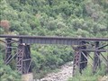
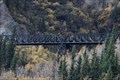
 view gallery view galleryS125.7 km |  ARR Dragonfly Creek Deck Girder Bridge -- Denali Borough, AK USA ARR Dragonfly Creek Deck Girder Bridge -- Denali Borough, AK USA
in Railroad Bridges This deck girder bridge over Dragonfly Creek carries the Alaska Railroad to Denali National Park. The coordinates are located at a viewing area along the Denali Highway. posted by: Benchmark Blasterz location: Alaska date approved: 12/01/2022 last visited: 01/30/2023 |
 view gallery view galleryS125.7 km | Sheep Creek Bridge - Denali National Park, Alaska in Railroad Bridges Alaska Railroad bridge in the north portion of Denali National Park. posted by:  BruceS BruceS location: Alaska date approved: 04/27/2011 last visited: 10/14/2022 |
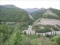 view gallery view galleryS125.7 km |  Parks Highway Nenana River Overlook Parks Highway Nenana River Overlook
in Scenic Roadside Look-Outs Overlook north of Denali National Park giving a view of the Nenana River Valley far below. posted by: BruceS location: Alaska date approved: 04/26/2011 last visited: 10/14/2022 |
 view gallery view galleryS127.8 km | ARR Pony Truss Bridge over an Unnamed Creek -- Denali Borough, AK, USA in Truss Bridges Very cool truss bridge over an unnamed creek is easily seen from the Parks Highway posted by: Benchmark Blasterz location: Alaska date approved: 12/01/2022 last visited: 01/30/2023 |
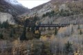 view gallery view galleryS127.8 km | ARR Pony Truss Bridge over an Unnamed Creek -- Denali Borough, AK, USA in Railroad Bridges Very cool truss bridge over an unnamed creek is easily seen from the Parks Highway. posted by: Benchmark Blasterz location: Alaska date approved: 12/01/2022 last visited: 01/30/2023 |
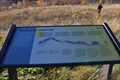
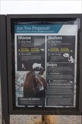 view gallery view galleryS128.1 km | Are You Prepared? — Savage River Picnic Area, Denali Park Road MP 13, Denali National Park, AK USA in Flora and Fauna Information Signs One of three flora and fauna information signs at the Savage River picnic area in the loop trail head in Denali National Park, this one gives excellent advice about dealing with moose, bear, and wolves - which are commonly seen in the park posted by: Benchmark Blasterz location: Alaska date approved: 12/01/2022 last visited: 01/30/2023 |
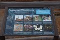 view gallery view galleryS128.1 km | Crossing Paths with the Locals -- Savage River Picnic Area, Denali Park Road MP 13, Denali National Park, AK USA in Flora and Fauna Information Signs Second of three flora and fauna information signs at the Savage River picnic area at the Savage River Loop trailhead in Denali National Park, this sign identifies local plants and animals commonly seen in this area posted by: Benchmark Blasterz location: Alaska date approved: 12/01/2022 last visited: 01/30/2023 |
 view gallery view galleryS128.1 km | Life on a Braided River-- Savage River Picnic Area, Denali Park Road MP 13, Denali National Park, AK USA in Flora and Fauna Information Signs Third of three flora and fauna information signs at the Savage River picnic area in the loop trail head in Denali National Park posted by: Benchmark Blasterz location: Alaska date approved: 12/01/2022 last visited: 01/30/2023 |
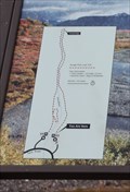 view gallery view galleryS128.1 km |  YAH -- Savage River Loop Trailhead, Denali Park Road MP 13, Denali National Park, AK USA YAH -- Savage River Loop Trailhead, Denali Park Road MP 13, Denali National Park, AK USA
in 'You Are Here' Maps A You are Here map at the Savage River Loop Trailhead at Denali National Park posted by: Benchmark Blasterz location: Alaska date approved: 12/01/2022 last visited: 01/30/2023 |
 view gallery view galleryS128.9 km | Ice Age Hunters - Denali National Park in Alaska Historic Markers Ice age hunters flowed the Caribou trails through Denali. Located at a rest stop along the Park Road in the Denali Nation Park. See parks web site for access information. posted by:  Lat34North Lat34North location: Alaska date approved: 01/23/2014 last visited: 07/11/2016 |
|