 view gallery view gallery NW13.7 km NW13.7 km
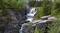
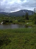
|   Rjukandefossen, Tuv, Hemsedal, Norway Rjukandefossen, Tuv, Hemsedal, Norway
in Waterfalls A powerfull warerfall posted by:  g300td g300td location: Viken, Norway date approved: 01/07/2013 last visited: 07/27/2013 |
 view gallery view gallery S15.9 km S15.9 km
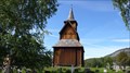
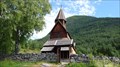
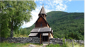
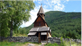
|  Torpo stave church, Buskerud, Norway Torpo stave church, Buskerud, Norway
in Medieval Churches The stave church signed by its craftman posted by: g300td location: Norway date approved: 01/07/2013 last visited: never |
 view gallery view gallery SE26.2 km SE26.2 km
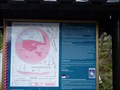
|  Gardnos Meteorite Crater - Nesbyen, Norway Gardnos Meteorite Crater - Nesbyen, Norway
in Impact Craters About 650 million years ago, a meteorite with a diameter of 300 meters struck Garnås in Nesbyen posted by: tmob location: Viken, Norway date approved: 02/10/2011 last visited: 09/30/2023 |
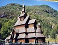 view gallery view galleryNW53.8 km |  Borgund Stavkyrkje - Borgund, Norway Borgund Stavkyrkje - Borgund, Norway
in Country Churches The beautiful Borgund Stave church dates from the 12th century and is one of the best preserved medieval churches in Norway. posted by: Becktracker location: Vestland, Norway date approved: 09/05/2021 last visited: 05/12/2022 |
 view gallery view galleryNW53.8 km |  Borgund Stavkyrkje - Borgund, Norway Borgund Stavkyrkje - Borgund, Norway
in Nordic Heritage The Borgund Stave church is one of the best preserved Medieval churches in Norway posted by: Becktracker location: Vestland, Norway date approved: 12/23/2022 last visited: 08/19/2023 |
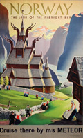 view gallery view galleryNW53.8 km |  Norway, Land of the Midnight Sun - Borgund - Norway Norway, Land of the Midnight Sun - Borgund - Norway
in Vintage Ad Locations This advertising poster from 1955 for tourism in Norway depicts the Church of Borgund posted by: Becktracker location: Vestland, Norway date approved: 06/17/2022 last visited: 06/24/2022 |
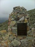
 view gallery view gallery W75 km W75 km
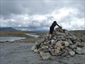
|  Cairn - Aurland-Lærdal road - Norway Cairn - Aurland-Lærdal road - Norway
in Cairns This cairn is located on the side of the FV23 road, that connects Aurland to Lærdal. posted by: tmob location: Vestland, Norway date approved: 07/28/2011 last visited: 06/11/2013 |
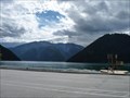 view gallery view galleryNW87.5 km |  Ferry from Kaupanger to Gudvangen - Nærøyfjord, Norway Ferry from Kaupanger to Gudvangen - Nærøyfjord, Norway
in Scenic Boat Rides This touristic ferry will take you to the Nærøyfjord, the narrowest fjord in the world and part of a UNESCO World Heritage Site. posted by: tmob location: Norway date approved: 02/15/2011 last visited: 09/15/2004 |
 view gallery view galleryNW90.8 km | Urnes Stave Church, Ornes, Norway in Medieval Churches The wooden church of Urnes posted by: g300td location: Norway date approved: 01/07/2013 last visited: 06/11/2013 |
 view gallery view galleryNW91.1 km |  Urnes Stave Church, Ornes, Norway Urnes Stave Church, Ornes, Norway
in Wikipedia Entries The wooden church of Urnes posted by: g300td location: Norway date approved: 11/09/2014 last visited: never |
 view gallery view galleryNW91.1 km | Urnes Stave Church, Ornes, Norway in This Old Church The wooden church of Urnes posted by: g300td location: Norway date approved: 11/08/2014 last visited: never |
 view gallery view galleryNW91.1 km |  Urnes Stave Church, Ornes, Norway Urnes Stave Church, Ornes, Norway
in World Heritage Sites The wooden church of Urnes posted by: g300td location: Norway date approved: 01/06/2013 last visited: 06/11/2013 |
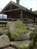
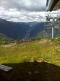 view gallery view galleryS101.7 km |  Fyrieggheisen - Rjukan, Norway Fyrieggheisen - Rjukan, Norway
in Aerial Lifts Fyrieggheisen. The given coordinates mark the upper station. posted by: Walking Boots location: Vestfold og Telemark, Norway date approved: 05/18/2020 last visited: never |
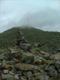 view gallery view galleryS105.6 km |  Gaustatoppen - Telemarken, Norway Gaustatoppen - Telemarken, Norway
in Geographic High Points Gaustatoppen is the highest mountain in Telemarken posted by: Walking Boots location: Vestfold og Telemark, Norway date approved: 05/19/2020 last visited: 06/24/2023 |
 view gallery view galleryS105.6 km |  Gaustatoppen -Rjukan - Telemarken, Norway Gaustatoppen -Rjukan - Telemarken, Norway
in Mountain Summits Gaustatoppen is the highest mountain in Telemarken posted by: Walking Boots location: Vestfold og Telemark, Norway date approved: 05/18/2020 last visited: 06/24/2023 |
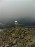 view gallery view galleryS105.6 km |  Weather Station Gaustatoppen - Rjukan, Norway Weather Station Gaustatoppen - Rjukan, Norway
in Weather Stations Weather station at Gaustatoppen posted by: Walking Boots location: Vestfold og Telemark, Norway date approved: 06/05/2020 last visited: never |
 view gallery view galleryS105.7 km |  FIRST mountaineering - Gaustatoppen - Rjukan, Norway FIRST mountaineering - Gaustatoppen - Rjukan, Norway
in First of its Kind First known mountaineering of the Gaustatoppen. posted by: Walking Boots location: Vestfold og Telemark, Norway date approved: 05/18/2020 last visited: never |
 view gallery view galleryS107.5 km |  1173 m - Elevation sign - Gaustahytta - Rjukan, Norway 1173 m - Elevation sign - Gaustahytta - Rjukan, Norway
in Elevation Signs Elevation sign on the way to Gaustatoppen posted by: Walking Boots location: Vestfold og Telemark, Norway date approved: 05/18/2020 last visited: never |
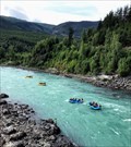 view gallery view gallery NE111.5 km NE111.5 km
|  Sjoa Raftingsenter - Otta, Norway Sjoa Raftingsenter - Otta, Norway
in Whitewater Rafting Trips Sjoa Rafting Center offers various activities that take place on the river Sjoa. posted by: Walking Boots location: Innlandet, Norway date approved: 08/26/2021 last visited: never |
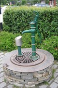 view gallery view gallery N115.6 km N115.6 km
|  Village Square Pump - Lom, Norway Village Square Pump - Lom, Norway
in Hand Operated Water Pumps A pump in the center of Lom village. posted by: haggaeus location: Innlandet, Norway date approved: 08/17/2012 last visited: 06/11/2013 |
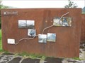
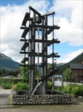 view gallery view galleryN115.6 km |  Water Sculpture - Lom, Norway Water Sculpture - Lom, Norway
in Fountains A high structure made of irrigation troughs in the center of Lom village. posted by: haggaeus location: Norway date approved: 08/17/2012 last visited: 11/06/2016 |
 view gallery view galleryN115.6 km |  Lucky 7 - Lom, Norway Lucky 7 - Lom, Norway
in Lucky 7 Seven waymarks in the pictorial Norwegian village of Lom. posted by: haggaeus location: Norway date approved: 08/18/2012 last visited: 06/11/2013 |
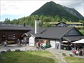
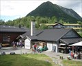 view gallery view galleryN115.6 km |  Lom Bakery Lom Bakery
in Independent Bakeries A bakery and cafe in the center of Lom village. posted by: haggaeus location: Norway date approved: 08/16/2012 last visited: 06/11/2013 |
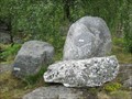 view gallery view galleryN115.6 km |  Minerals of Jotunheimen - Lom, Norway Minerals of Jotunheimen - Lom, Norway
in Rock and Mineral Displays Three different rocks at trailside in Lom Village. posted by: haggaeus location: Innlandet, Norway date approved: 07/24/2012 last visited: 06/11/2013 |
 view gallery view galleryN115.7 km |  Sognefjellet - Lom, Norway Sognefjellet - Lom, Norway
in National Scenic Byways Start of route 55 - Sognefjellet - in Lom village. posted by: haggaeus location: Innlandet, Norway date approved: 07/24/2012 last visited: 06/11/2013 |
|