 view gallery view gallery S16.4 km S16.4 km
|   John Hart Hiway Traffic Webcam - Dawson Creek, BC John Hart Hiway Traffic Webcam - Dawson Creek, BC
in Web Cameras Hwy 97 (John Hart Hwy) at Mason-Semple Rd, looking east. This is a short 15 km. west of Dawson Creek. We are now all the way up into what is known as the Peace Country. posted by:  T0SHEA T0SHEA location: British Columbia, Canada date approved: 10/07/2013 last visited: 01/14/2014 |
 view gallery view gallery SE21.1 km SE21.1 km
| Dawson Creek Traffic Webcam-N - Dawson Creek, BC in Web Cameras Hiway 97 at Dangerous Goods Route, on the western edge of Dawson Creek. posted by: T0SHEA location: British Columbia, Canada date approved: 10/07/2013 last visited: 01/06/2014 |
 view gallery view gallerySE21.1 km | Dawson Creek Traffic Webcam-W - Dawson Creek, BC in Web Cameras Hwy 97 at Dangerous Goods Route, on the western edge of Dawson Creek. posted by: T0SHEA location: British Columbia, Canada date approved: 10/07/2013 last visited: 01/06/2014 |
 view gallery view gallerySE21.1 km | Dawson Creek Traffic Webcam-S - Dawson Creek, BC in Web Cameras Hwy 97 at Dangerous Goods Route, on the western edge of Dawson Creek. posted by: T0SHEA location: British Columbia, Canada date approved: 10/07/2013 last visited: 01/06/2014 |
 view gallery view gallerySE21.1 km | Dawson Creek Traffic Webcam-E - Dawson Creek, BC in Web Cameras Hwy 97 at Dangerous Goods Route, on the western edge of Dawson Creek. posted by: T0SHEA location: British Columbia, Canada date approved: 10/07/2013 last visited: 01/06/2014 |
 view gallery view gallerySE21.6 km |  Mile 0 Campground, Dawson Creek, British Columbia Mile 0 Campground, Dawson Creek, British Columbia
in Campgrounds Mile 0 Campground in Dawson Creek is just off the Alaska Hwy./97 Hwy. slightly north of downtown. posted by: T0SHEA location: British Columbia, Canada date approved: 07/23/2019 last visited: never |
 view gallery view gallerySE21.7 km |  Mile "0" Park Playground - Dawson Creek, British Columbia Mile "0" Park Playground - Dawson Creek, British Columbia
in Public Playgrounds Mile "0" Park is located on Haer Hwy. and 20th Street. posted by: T0SHEA location: British Columbia, Canada date approved: 07/23/2021 last visited: never |
 view gallery view gallerySE21.7 km |  Mile "0" Park - Dawson Creek, British Columbia Mile "0" Park - Dawson Creek, British Columbia
in Municipal Parks and Plazas Mile "0" Park is located on Hart Hwy. and 20th Street. posted by: T0SHEA location: British Columbia, Canada date approved: 07/23/2021 last visited: never |
 view gallery view gallerySE21.9 km |  Dawson Creek Cemetery - Dawson Creek, British Columbia Dawson Creek Cemetery - Dawson Creek, British Columbia
in Worldwide Cemeteries Dawson Creek Cemetery entrance is at the John Hart Hwy. and 20th Street. posted by: T0SHEA location: British Columbia, Canada date approved: 08/31/2019 last visited: never |
 view gallery view gallerySE22.7 km |  Alliance Church - Dawson Creek, British Columbia Alliance Church - Dawson Creek, British Columbia
in Religious Buildings Multifarious Alliance Church in Dawson Creek is in the north side of town in a nice neighborhood. posted by: T0SHEA location: British Columbia, Canada date approved: 07/12/2019 last visited: never |
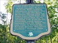
 view gallery view gallery N22.7 km N22.7 km
|  The First Highway - Taylor, BC The First Highway - Taylor, BC
in British Columbia Heritage Markers At the top of the South Taylor Hill, about 7 kilometres south of the Town of Taylor, is a large pullout/rest area/brake check area in which stands a very interesting British Columbia Stop of Interest marker. posted by: T0SHEA location: British Columbia, Canada date approved: 09/07/2019 last visited: never |
 view gallery view galleryN22.7 km |  ONLY - River Which Runs Through the Rocky Mountains ONLY - River Which Runs Through the Rocky Mountains
in Superlatives At the top of the South Taylor Hill, about 7 kilometres south of the Town of Taylor, British Columbia is a large pullout/rest area/brake check area in which stands a very interesting British Columbia Stop of Interest marker. posted by: T0SHEA location: British Columbia, Canada date approved: 09/02/2019 last visited: never |
 view gallery view galleryN22.7 km |  FIRST - "Highway" Through the Rocky Mountains FIRST - "Highway" Through the Rocky Mountains
in First of its Kind At the top of the South Taylor Hill, about 7 kilometres south of the Town of Taylor, British Columbia is a large pullout/rest area/brake check area in which stands a very interesting British Columbia Stop of Interest marker. posted by: T0SHEA location: British Columbia, Canada date approved: 09/03/2019 last visited: never |
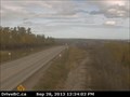 view gallery view galleryN22.9 km | South Taylor Hill Traffic Webcam - Taylor, BC in Web Cameras Hwy 97 at South Taylor Hill, 20 km south of Fort St John, across the river from Taylor. posted by: T0SHEA location: British Columbia, Canada date approved: 10/07/2013 last visited: 01/14/2014 |
 view gallery view gallerySE22.9 km | Church of the New Jerusalem - Dawson Creek, British Columbia in Religious Buildings Multifarious The Church of the New Jerusalem in Dawson Creek is located in the north end of town. Take the roundabout and proceed north on 8th Street. posted by: T0SHEA location: British Columbia, Canada date approved: 07/15/2019 last visited: never |
 view gallery view gallerySE23.2 km |  Tim Hortons - Dawson Creek, British Columbia Tim Hortons - Dawson Creek, British Columbia
in Wi-Fi Hotspots This Tim Hortons, complete with WiFi, is co-located with a FasGas Service Station on the northwest corner of Dawson Creek, British Columbia. posted by:  wildwoodke wildwoodke location: British Columbia, Canada date approved: 09/29/2013 last visited: never |
 view gallery view gallerySE23.2 km |  Tim Hortons - Dawson Creek, BC Tim Hortons - Dawson Creek, BC
in Tim Horton's Restaurants This Tim Hortons is co-located with a FasGas Service Station on the northwest corner of Alaska Ave in Dawson Creek. posted by: wildwoodke location: British Columbia, Canada date approved: 09/29/2013 last visited: never |
 view gallery view gallerySE23.2 km | Grand View Chapel - Dawson Creek, British Columbia in Religious Buildings Multifarious Grand View Chapel is located in the northern part of town. posted by: T0SHEA location: British Columbia, Canada date approved: 07/14/2019 last visited: never |
 view gallery view gallerySE23.2 km |  BC Ambulance Service Station 856 - Dawson Creek, British Columbia BC Ambulance Service Station 856 - Dawson Creek, British Columbia
in Paramedic Stations BC Ambulance Service Station 856 in Dawson Creek is located at 10101 13th Street. posted by: T0SHEA location: British Columbia, Canada date approved: 07/26/2019 last visited: never |
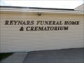 view gallery view gallerySE23.3 km |  Reynars Funeral Home & Crematorium - Dawson Creek, British Columbia Reynars Funeral Home & Crematorium - Dawson Creek, British Columbia
in Funeral Homes Reynars Funeral Home & Crematorium is located at 1300 102 Avenue. posted by: T0SHEA location: British Columbia, Canada date approved: 07/18/2021 last visited: never |
 view gallery view gallerySE23.3 km |  Dawson Creek, British Columbia Dawson Creek, British Columbia
in City and Town Halls A city of around 12,000, Dawson Creek is the official starting point of the Alaska Highway. posted by: T0SHEA location: British Columbia, Canada date approved: 07/12/2021 last visited: never |
 view gallery view gallerySE23.3 km |  Dawson Creek, British Columbia Dawson Creek, British Columbia
in People-Named Places A city of around 12,000, Dawson Creek is the official starting point of the Alaska Highway. posted by: T0SHEA location: British Columbia, Canada date approved: 07/12/2021 last visited: never |
 view gallery view gallerySE23.3 km |  Dawson Creek, British Columbia Dawson Creek, British Columbia
in Wikipedia Entries A city of around 12,000, Dawson Creek is the official starting point of the Alaska Highway. posted by: T0SHEA location: British Columbia, Canada date approved: 07/12/2021 last visited: never |
 view gallery view gallerySE23.3 km |  Dawson Creek, British Columbia Dawson Creek, British Columbia
in Lucky 7 A city of around 12,000, Dawson Creek is the official starting point of the Alaska Highway. posted by: T0SHEA location: British Columbia, Canada date approved: 07/22/2021 last visited: never |
 view gallery view gallerySE23.3 km |  Dawson Creek City Hall evacuated after threat Dawson Creek City Hall evacuated after threat
in News Article Locations A city of around 13,000, Dawson Creek is the official starting point of the Alaska Highway. posted by: T0SHEA location: British Columbia, Canada date approved: 07/13/2021 last visited: never |
|