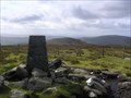
 view gallery view gallery NE11.9 km NE11.9 km
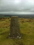
|   Sawel, Sperrin Mountains, Co. Derry Sawel, Sperrin Mountains, Co. Derry
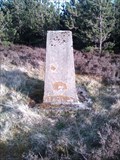
in U.K. and Ireland Trigpoints Trig Pillar at the summit of Sawel Mountain (678m) posted by:  dino-irl dino-irl location: Ireland date approved: 10/29/2007 last visited: 07/13/2009 |
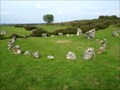 view gallery view gallery E14.2 km E14.2 km
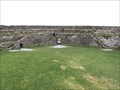
|  Beaghmore - Northern Ireland Beaghmore - Northern Ireland
in Wikipedia Entries Beaghmore is a complex of early Bronze Age megalithic features, stone circles and cairns, 8.5 miles north west of Cookstown, County Tyrone in Northern Ireland. posted by:  Noe1 Noe1 location: Ulster, Ireland date approved: 11/04/2014 last visited: 06/03/2021 |
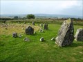 view gallery view galleryE14.2 km |  Beaghmore Stone Circles - Northern Ireland Beaghmore Stone Circles - Northern Ireland
in Megalithic Monuments Beaghmore is a complex of early Bronze Age megalithic features, stone circles and cairns, 8.5 miles north west of Cookstown, County Tyrone in Northern Ireland. posted by: Noe1 location: Ulster, Ireland date approved: 11/04/2014 last visited: 06/03/2021 |
 view gallery view gallery SW17.5 km SW17.5 km
|  Omagh Bomb Memorial - Omagh Co Tyrone Omagh Bomb Memorial - Omagh Co Tyrone
in Disaster Memorials At 3.10 p.m. on Saturday afternoon, August 15, 1998, a car bomb exploded in a crowded shopping area of Omagh, Co Tyrone. posted by: Windsocker location: Ireland date approved: 12/28/2008 last visited: 10/19/2013 |
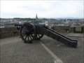 view gallery view gallery N31.1 km N31.1 km
|  Cannons on the Walls of Derry, Derry, Northern Ireland, UK Cannons on the Walls of Derry, Derry, Northern Ireland, UK
in Static Artillery Displays Cannons used during the Siege of Derry (Irish: Léigear Dhoire) in 1689. posted by: Noe1 location: United Kingdom date approved: 06/15/2012 last visited: never |
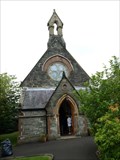 view gallery view galleryN31.2 km |  St. Augustine's Church - Derry, Northern Ireland St. Augustine's Church - Derry, Northern Ireland
in Anglican and Episcopal Churches A neo-Gothic church of 1872. posted by: Noe1 location: United Kingdom date approved: 11/11/2014 last visited: never |
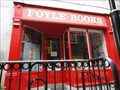 view gallery view galleryN31.2 km |  Foyle Books Foyle Books
in Used Book Stores Located on magazine street in the Craft Village, this store is "the ultimate" place to find a great read! posted by: DnRseekers location: Ulster, Ireland date approved: 09/13/2012 last visited: 07/18/2012 |
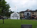
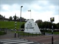 view gallery view galleryN31.4 km | Free Derry Corner - Derry, Northern Ireland in Wikipedia Entries Free Derry Corner is a historical landmark in the Bogside neighbourhood of Derry, Northern Ireland. posted by: Noe1 location: Ulster, Ireland date approved: 11/04/2014 last visited: never |
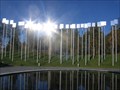
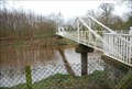
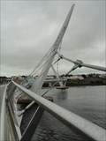 view gallery view galleryN31.4 km |  The Peace Bridge The Peace Bridge
in Pedestrian Suspension Bridges A tribute to the peace process in Northern Ireland, this bridge spans the Foyle River from the town of Derry to the former British Barracks. The river is the dividing line between the Republic of Ireland and the United Kingdom. posted by: DnRseekers location: Ulster, Ireland date approved: 09/13/2012 last visited: 07/18/2012 |
 view gallery view galleryN31.4 km | The Peace Bridge, Derry, Ireland in Wikipedia Entries Open in 2011, this unique pedestrian suspension bridge crosses the Foyle River uniting the Republic of Ireland with the United Kingdom. posted by: DnRseekers location: Ulster, Ireland date approved: 09/15/2012 last visited: 08/15/2016 |
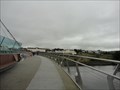 view gallery view galleryN31.4 km |  One Millionth Crossing of the Peace Bridge One Millionth Crossing of the Peace Bridge
in News Article Locations Opened in 2011, the Derry Peace Bridge has attracted one million pedestrians and cyclists in just over one year. posted by: DnRseekers location: Ulster, Ireland date approved: 09/12/2012 last visited: 07/18/2012 |
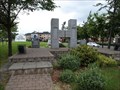 view gallery view galleryN31.4 km |  Hunger strike memorial in Bogside- Derry, Ulster, Northern Ireland Hunger strike memorial in Bogside- Derry, Ulster, Northern Ireland
in Civil Rights Memorials The H Block Hunger Strike Memorial in Derry, Northern Ireland posted by: Noe1 location: Ulster, Ireland date approved: 03/19/2013 last visited: 04/11/2014 |
 view gallery view galleryN31.4 km | Bogside - Derry, Northern Ireland in Wikipedia Entries The Bogside (Irish: Taobh an Bhogaigh) is a Catholic neighbourhood outside the city walls of Derry, Northern Ireland. posted by: Noe1 location: Ulster, Ireland date approved: 11/04/2014 last visited: 04/11/2014 |
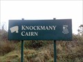 view gallery view gallery S31.7 km S31.7 km
| Knockmany Cairn in Megalithic Monuments Knockmany (Cnoc mBaine = 'the Hill of Queen Baine' the wife of the first century King Tuathal Techtmar) posted by: Windsocker location: Ireland date approved: 11/16/2008 last visited: 12/13/2009 |
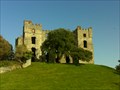 view gallery view gallery NW32.5 km NW32.5 km
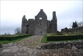
|  Raphoe Castle Raphoe Castle
in Castles The ruins of Raphoe Castle, near the town of Raphoe, Ireland. posted by: Happy Paddlers location: Ireland date approved: 10/18/2010 last visited: never |
 view gallery view galleryNW33.8 km | Dooish Mountain, Raphoe. Co. Donegal in U.K. and Ireland Trigpoints An unmapped trigpoint at the top of Dooish Mountain (276m) near Raphoe. posted by: dino-irl location: Ulster, Ireland date approved: 04/25/2010 last visited: never |
 view gallery view galleryNW36.9 km |  Grianan Aileach - County Donegal, Ireland Grianan Aileach - County Donegal, Ireland
in Historic Forts A beautifully preserved hillfort atop the 244 high Greenan Mountain at Inishowen in County Donegal, Ireland. posted by: flyingmoose location: Ulster, Ireland date approved: 06/29/2020 last visited: never |
 view gallery view gallery SE36.9 km SE36.9 km
|  Cycle Route 95 - Dungannon Lake Park Cycle Route 95 - Dungannon Lake Park
in Cycling Routes This traffic-free route is great for a family ride with young children. Dungannon Park, on the edge of Dungannon, is a beautifully kept area with a trout-fishing lake and lots of activities, and is wonderful for exploring by bike. posted by: Windsocker location: Ireland date approved: 03/03/2008 last visited: 06/22/2021 |
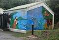 view gallery view gallerySE37 km |  Wise Woman - Dungannon Northern Ireland Wise Woman - Dungannon Northern Ireland
in Murals This is a large mural in Dungannon park Northern Ireland posted by: Windsocker location: Ireland date approved: 03/02/2008 last visited: 10/02/2013 |
 view gallery view gallerySE47.6 km | Dredge Bridge - Caledon Co Tyrone in Pedestrian Suspension Bridges James Dredge was a mid-19th century designer-builder of suspension bridges who came to prominence in Britain at a time when there was great interest, in Europe generally, in the rapidly evolving technology of such structures posted by: Windsocker location: Ireland date approved: 03/02/2008 last visited: never |
 view gallery view gallerySW48 km | Mullyknock Hill, Fermanagh in U.K. and Ireland Trigpoints This trig point is situated at a height of 277 meters on Mullyknock Hill also know as Top mountain. It is to the east of Enniskillen in Fermanagh. posted by: Windsocker location: Ulster, Ireland date approved: 03/29/2010 last visited: 09/21/2013 |
 view gallery view gallerySW52.3 km | Tully Castle - Co Fermanagh in Castles This three storey strong castle, 15m long and 6m broad, was protected by a bawn of lime and stone 3m square and 4m high, containing four flankers. posted by: Windsocker location: Ireland date approved: 03/07/2008 last visited: 01/02/2020 |
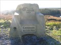 view gallery view galleryS52.3 km |  Have a Seat - Carnrock Co. Fermanagh Have a Seat - Carnrock Co. Fermanagh
in Time Capsules A Time Capsule located in Lisnaskea Forest near Slieve Beagh. It's an easy walk from the roadside carpark. posted by: Windsocker location: Ireland date approved: 12/19/2008 last visited: 09/19/2013 |
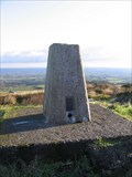 view gallery view galleryS52.3 km | Trig Pillar - Carnrock Co. Fermanagh in U.K. and Ireland Trigpoints A trig pillar located in Lisnaskea Forest near Slieve Beagh. It's an easy walk from the roadside carpark.
posted by: Windsocker location: Ireland date approved: 12/19/2008 last visited: 09/19/2013 |
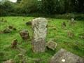 view gallery view gallerySW52.8 km |  Boa Island Cemetery - Ulster, Northern Ireland Boa Island Cemetery - Ulster, Northern Ireland
in Worldwide Cemeteries Ancient island cemetery still in use. posted by: Noe1 location: Ulster, United Kingdom date approved: 03/25/2013 last visited: never |
|