 view gallery view gallery W1.8 km W1.8 km
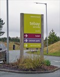
|   Westmorland Services M6 - Tebay, Cumbria UK Westmorland Services M6 - Tebay, Cumbria UK
in Highway Rest Areas Award winning, independent motorway services just north of Tebay, J38 of the M6. Includes hotel and caravan site, plus farm shop selling local produce. posted by:  martlakes martlakes location: North West England, United Kingdom date approved: 03/11/2008 last visited: never |
 view gallery view gallery S1.8 km S1.8 km
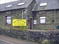
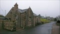
|  The Old School - Tebay, Cumbria UK The Old School - Tebay, Cumbria UK
in Dog Friendly Hotels Just off the M6 at J38 is the small village of Tebay. The old school is now a B&B with a range of accommodation options. They are happy to welcome well behaved pets. Behind the building is the start of the open hills of the Howgill Fells. posted by: martlakes location: North West England, United Kingdom date approved: 03/11/2008 last visited: never |
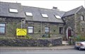 view gallery view galleryS1.8 km |  The Old School B&B - Tebay, Cumbria UK The Old School B&B - Tebay, Cumbria UK
in Bed and Breakfast A lovely B&B at the foot of the Howgill Fells, in the village of Tebay, just 1 minute from J38 of the M6. posted by: martlakes location: North West England, United Kingdom date approved: 03/11/2008 last visited: never |
 view gallery view galleryS1.8 km |  Tebay School - Tebay, Cumbria, UK Tebay School - Tebay, Cumbria, UK
in Former Schools The old school in the village of Tebay, now a B&B. A new school has been built a little further south. posted by: martlakes location: United Kingdom date approved: 03/11/2008 last visited: never |
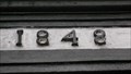 view gallery view gallery SE1.8 km SE1.8 km
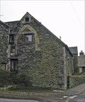
|  1848 - New House, Gaisgill, Cumbria 1848 - New House, Gaisgill, Cumbria
in Dated Buildings and Cornerstones New House is a grade 2 listed house on a slight rise in the road west out of Gaisgill. posted by: flipflopnick location: North West England, United Kingdom date approved: 03/02/2012 last visited: never |
 view gallery view gallerySE1.9 km |  Former Gaisgill Methodist Chapel - Gaisgill, Cumbria Former Gaisgill Methodist Chapel - Gaisgill, Cumbria
in Methodist Churches The former Wesleyan Chapel closed in 2003, after opening in 1841, providing a fixed meeting place for those Methodists who had outgrown their previous peripatetic venues. posted by: flipflopnick location: North West England, United Kingdom date approved: 03/02/2012 last visited: never |
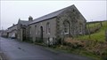 view gallery view gallerySE1.9 km |  Former Methodist Chapel - Gaisgill, Cumbria Former Methodist Chapel - Gaisgill, Cumbria
in This Old Church The chapel was built for £102 in 1841 by local Gaisgill Methodists after buying the land for £1. posted by: flipflopnick location: North West England, United Kingdom date approved: 03/02/2012 last visited: never |
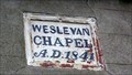 view gallery view gallerySE1.9 km | 1841 - Gaisgill Chapel, Cumbria in Dated Buildings and Cornerstones After meeting in each others houses for over 70 years, local Gaisgill Methodists built their own chapel in 1841. posted by: flipflopnick location: North West England, United Kingdom date approved: 03/02/2012 last visited: never |
 view gallery view gallery N2.1 km N2.1 km
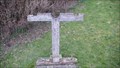
|  Pillory, Orton, Cumbria Pillory, Orton, Cumbria
in Punishment and Disciplinary Devices This pillory have been in use for many centuries, between the church and centre of Orton. posted by: flipflopnick location: North West England, United Kingdom date approved: 02/29/2012 last visited: never |
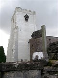 view gallery view galleryN2.1 km | All Saints church-Orton,Cumbria England. in This Old Church All Saints church Orton,stands proudly at the head of the village,it's white painted stone tower a landmark.
posted by:  fellsmanhiker fellsmanhiker location: United Kingdom date approved: 09/15/2008 last visited: 09/24/2008 |
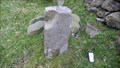
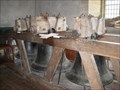 view gallery view galleryN2.1 km |  Orton church original bells Orton church original bells
in Bells The original church bells of All Saints Orton,Cumbria are of important archaeological interest,and that is the reason they have been preserved and placed on public display. posted by: fellsmanhiker location: United Kingdom date approved: 09/15/2008 last visited: 09/24/2008 |
 view gallery view galleryS3.5 km |  Runaway Wagon - Tebay, Cumbria UK Runaway Wagon - Tebay, Cumbria UK
in Railway Disaster Sites On 15th Feb 2004 a maintenance crew were working on the west coast mainline at Tebay. Without warning an unmanned trolley carrying over 15 tons of 18ft long steel rail sections came crashing into them out of the darkness. posted by: martlakes location: North West England, United Kingdom date approved: 03/11/2008 last visited: 03/15/2008 |
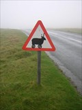 view gallery view galleryN3.7 km |  Sheep on Crosby Ravensworth Fell, Cumbria Sheep on Crosby Ravensworth Fell, Cumbria
in Uncommon Crossing Signs A sign warning of sheep on the road, possibly on wheels with impressive horns. posted by: flipflopnick location: North West England, United Kingdom date approved: 09/13/2007 last visited: never |
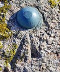 view gallery view gallery NW5.1 km NW5.1 km
|  Galloway Stone - Shap, Cumbria UK Galloway Stone - Shap, Cumbria UK
in U.K. and Ireland Trigpoints A benchmark on a handy boulder, close by the M6. Found on the Shap = Orton road. The boulder is named on the map, implying it's an erratic from southern Scotland. posted by: martlakes location: United Kingdom date approved: 02/20/2008 last visited: 05/26/2015 |
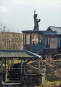 view gallery view galleryNW5.5 km |  Statue of Liberty - Shap Wells, Cumbria UK Statue of Liberty - Shap Wells, Cumbria UK
in Exact Replicas A scale replica of the famous New York statue in the middle of Shap Moors. posted by: martlakes location: United Kingdom date approved: 03/15/2008 last visited: never |
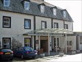 view gallery view galleryNW5.5 km |  Shap Wells Hotel - Penrith, Cumbria UK Shap Wells Hotel - Penrith, Cumbria UK
in Antique Hotels Shap Wells was opened in 1833 to serve the growing numbers of visitors coming to take the waters of the spa, located in the hotel's grounds. It continues today and is a favourite stopping point for coach parties on the way to Scotland. posted by: martlakes location: United Kingdom date approved: 03/16/2008 last visited: never |
 view gallery view galleryNW5.5 km |  Shap Wells Hotel - Penrith, Cumbria UK Shap Wells Hotel - Penrith, Cumbria UK
in WWII Prisoner of War Camps Shap Wells was opened in 1833 to serve the growing numbers of visitors coming to take the waters of the spa, located in the hotel's grounds. In the Second World War it had some different guests. posted by: martlakes location: North West England, United Kingdom date approved: 04/05/2008 last visited: never |
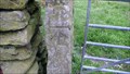 view gallery view galleryS6.4 km | Cut Mark on Gatepost, near Low Carlingill, Fairmile Road, Cumbria in U.K. and Ireland Trigpoints An obvious mark on a limestone gatepost in a very scenic valley. Behind is M6, main West Coast rail line and A685 all going through the narrows of Tebay gorge, with river Lune on the valley bottom. posted by: flipflopnick location: North West England, United Kingdom date approved: 08/18/2009 last visited: never |
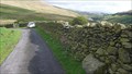 view gallery view galleryS6.6 km | Rivet on boulder, Low Carlingill, Cumbria in U.K. and Ireland Trigpoints This section of road has walls, and the OS chose this boulder built into the drystone wall. On the west verge of tarmac road as it starts to bend down to Carlingill. posted by: flipflopnick location: North West England, United Kingdom date approved: 08/22/2009 last visited: never |
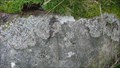 view gallery view galleryS7.4 km | Rivet on Boulder, Fairmile Road, Howgill, Cumbria in U.K. and Ireland Trigpoints Along this featureless open road there is little for the Ordnance Survey to leave their graffiti on. This boulder is 3 metres from the east side of the road. The rivet has gone leaving the hole. posted by: flipflopnick location: North West England, United Kingdom date approved: 08/22/2009 last visited: never |
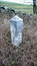 view gallery view galleryS7.7 km |  Dillicar - Grayrigg boundary stone, A685, Cumbria Dillicar - Grayrigg boundary stone, A685, Cumbria
in Public Land Survey Marks A boundary stone on the south side of the A685 on the old turnpike between Kendal and Tebay. posted by: flipflopnick location: North West England, United Kingdom date approved: 12/22/2008 last visited: never |
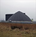 view gallery view galleryNW7.9 km |  Hardendale Salt Store - Shap, Cumbria UK Hardendale Salt Store - Shap, Cumbria UK
in Odd-Shaped Buildings As you drive south down the M6 a large circular dome appears sitting beside the motorway. It looks like some sort of planetarium or concert hall in the middle of the moor. It is in fact part of the road maintenance depot. posted by: martlakes location: United Kingdom date approved: 03/11/2008 last visited: 03/21/2008 |
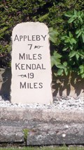 view gallery view galleryN8.4 km |  Dalefoot milestone, Crosby Ravensworth, Cumbria Dalefoot milestone, Crosby Ravensworth, Cumbria
in Milestones A fine stone mile marker in a garden. Visible from the public road over the wall, in Crosby Ravensworth. posted by: flipflopnick location: North West England, United Kingdom date approved: 05/08/2011 last visited: never |
 view gallery view galleryS8.5 km | Orton 7 Sedbergh 4 Fairmile Gate, Sedbergh, Cumbria in Milestones This small square block, showing distances to nearby towns, is set back from the lane, which would have been a main road north long before the M6 motorway. Sedbergh, 4 miles south, was a hub for many turnpikes radiating out across the dales. posted by: flipflopnick location: North West England, United Kingdom date approved: 08/18/2009 last visited: never |
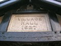 view gallery view galleryN8.5 km | 1927 - Crosby Ravensworth Village Hall, Cumbria in Dated Buildings and Cornerstones The village hall in Crosby Ravensworth hosts many local activities. It was built between the world wars. On its walls are mounted the names of the fallen from both world wars. posted by: flipflopnick location: North West England, United Kingdom date approved: 05/09/2011 last visited: never |
|