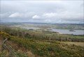
 view gallery view gallery S8.2 km S8.2 km
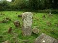
|   Mullyknock Hill, Fermanagh Mullyknock Hill, Fermanagh
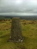
in U.K. and Ireland Trigpoints This trig point is situated at a height of 277 meters on Mullyknock Hill also know as Top mountain. It is to the east of Enniskillen in Fermanagh. posted by:  Windsocker Windsocker location: Ulster, Ireland date approved: 03/29/2010 last visited: 09/21/2013 |
 view gallery view gallery SW11.9 km SW11.9 km
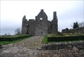
|  Portora Castle - Enniskillen Co Fermanagh Portora Castle - Enniskillen Co Fermanagh
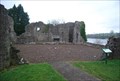
in Castles Portora Castle Enniskillen Co Fermanagh Northern Ireland is positioned by the narrow exit of the river Erne into the Lower Lough, it was built for Sir William Cole who purchased the land in 1612. posted by: Windsocker location: Ireland date approved: 03/07/2008 last visited: 06/15/2013 |
 view gallery view gallerySW11.9 km |  Our Glorious Dead - Enniskillen Co Fermanagh Our Glorious Dead - Enniskillen Co Fermanagh
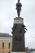
in World War I Memorials and Monuments Our Glorious dead are the inscription on this memorial to the soldiers that lost their lives in World War One. posted by: Windsocker location: Ireland date approved: 03/08/2008 last visited: never |
 view gallery view gallerySW11.9 km |  East Bridge - Enniskillen Co Fermanagh East Bridge - Enniskillen Co Fermanagh
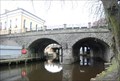
in Arch Bridges The East Bridge is sandwiched between two more modern bridges. posted by: Windsocker location: Ireland date approved: 03/07/2008 last visited: never |
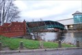 view gallery view gallerySW12.1 km |  Erne Bridge - Enniskillen Co Fermanagh Erne Bridge - Enniskillen Co Fermanagh
in Truss Bridges This is a new Truss bridge built for pedestrian access to the Erne side shopping centre posted by: Windsocker location: Ireland date approved: 03/07/2008 last visited: 06/16/2014 |
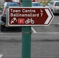 view gallery view gallerySW12.2 km |  Cycle Route 91 Enniskillen Co Fermanagh Cycle Route 91 Enniskillen Co Fermanagh
in Cycling Routes The North West Trail is a 326km circular cycle route through counties Donegal, Tyrone, Fermanagh, Leitrim, and Sligo in the North West of Ireland. Travelling through a wide variety of scenic landscapes. posted by: Windsocker location: Ireland date approved: 03/08/2008 last visited: never |
 view gallery view gallery W14.8 km W14.8 km
| Monea Castle - Co Fermanagh in Castles Monea Castle - Co Fermanagh Northern Ireland was built for Malcolm Hamilton, a native of Scotland in 1618. posted by: Windsocker location: Ireland date approved: 03/07/2008 last visited: 11/29/2007 |
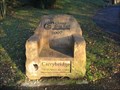 view gallery view galleryS16.6 km |  Have a Seat - Carrybridge Co. Fermanagh Have a Seat - Carrybridge Co. Fermanagh
in Time Capsules A Time Capsule located in Carrybridge Co Fermanagh. posted by: Windsocker location: Ireland date approved: 12/19/2008 last visited: 08/01/2013 |
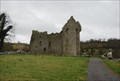
 view gallery view galleryW17.9 km | Tully Castle - Co Fermanagh in Castles This three storey strong castle, 15m long and 6m broad, was protected by a bawn of lime and stone 3m square and 4m high, containing four flankers. posted by: Windsocker location: Ireland date approved: 03/07/2008 last visited: 01/02/2020 |
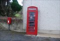 view gallery view galleryW20.1 km |  Red Telephone - Tooneel Co Fermanagh Red Telephone - Tooneel Co Fermanagh
in Red Telephone Boxes This Red telephone box is in the small village of Tooneel Co Fermanagh posted by: Windsocker location: Ulster, Ireland date approved: 03/07/2008 last visited: 01/10/2008 |
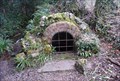 view gallery view gallerySW22.9 km |  St Bridgits Well - Co Fermangh St Bridgits Well - Co Fermangh
in Holy Wells A nice old well in the grounds of Florencecourt, Co. Fermanagh posted by: Windsocker location: Ireland date approved: 03/09/2008 last visited: 10/11/2007 |
 view gallery view galleryW23.2 km |  Boa Island Cemetery - Ulster, Northern Ireland Boa Island Cemetery - Ulster, Northern Ireland
in Worldwide Cemeteries Ancient island cemetery still in use. posted by:  Noe1 Noe1 location: Ulster, United Kingdom date approved: 03/25/2013 last visited: never |
 view gallery view gallery NE24 km NE24 km
|  Omagh Bomb Memorial - Omagh Co Tyrone Omagh Bomb Memorial - Omagh Co Tyrone
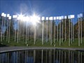
in Disaster Memorials At 3.10 p.m. on Saturday afternoon, August 15, 1998, a car bomb exploded in a crowded shopping area of Omagh, Co Tyrone. posted by: Windsocker location: Ireland date approved: 12/28/2008 last visited: 10/19/2013 |
 view gallery view gallery E24.3 km E24.3 km
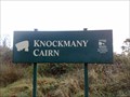
|  Knockmany Cairn Knockmany Cairn
in Megalithic Monuments Knockmany (Cnoc mBaine = 'the Hill of Queen Baine' the wife of the first century King Tuathal Techtmar) posted by: Windsocker location: Ireland date approved: 11/16/2008 last visited: 12/13/2009 |
 view gallery view gallery SE24.9 km SE24.9 km
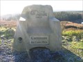
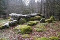
| Have a Seat - Carnrock Co. Fermanagh in Time Capsules A Time Capsule located in Lisnaskea Forest near Slieve Beagh. It's an easy walk from the roadside carpark. posted by: Windsocker location: Ireland date approved: 12/19/2008 last visited: 09/19/2013 |
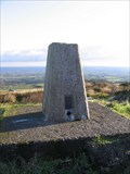 view gallery view gallerySE24.9 km | Trig Pillar - Carnrock Co. Fermanagh in U.K. and Ireland Trigpoints A trig pillar located in Lisnaskea Forest near Slieve Beagh. It's an easy walk from the roadside carpark.
posted by: Windsocker location: Ireland date approved: 12/19/2008 last visited: 09/19/2013 |
 view gallery view gallerySW27.4 km |  Marlbank Scenic Loop - Co Fermanagh Ireland Marlbank Scenic Loop - Co Fermanagh Ireland
in Scenic Roadside Look-Outs One of the many viewpoints on the in Marlbank Scenic Loop in Co Fermanagh Northern Ireland posted by: Windsocker location: Ireland date approved: 03/10/2008 last visited: 01/10/2008 |
 view gallery view gallerySW29.1 km | The Giant's Grave - Burren Co Cavan in Megalithic Monuments The Giant's Grave - Burren Co Cavan on Tullygobban Hill is a fairly large wedge-tomb whose gallery is about 10 metres long and 2 metres wide. posted by: Windsocker location: Ireland date approved: 03/07/2008 last visited: 02/09/2008 |
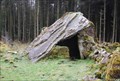 view gallery view gallerySW29.5 km | The Calf House - Burren Co Cavan in Megalithic Monuments This is one of a number of tombs in the townland of Burren Co Cavan it has two enormous outward-splaying portal-stones and a low door-stone. posted by: Windsocker location: Ireland date approved: 03/07/2008 last visited: 08/24/2008 |
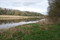 view gallery view gallerySW33.5 km |  ORIGIN River Shannon - Co Cavan Ireland ORIGIN River Shannon - Co Cavan Ireland
in River Origins, Destinations and Confluences The Shannon Pot in Co Cavan is said to be the traditional source of the River Shannon. posted by: Windsocker location: Ulster, Ireland date approved: 03/18/2008 last visited: 02/09/2008 |
 view gallery view gallery NW43 km NW43 km
|  St. Agatha's Church - Clar, Ireland St. Agatha's Church - Clar, Ireland
in Roman Catholic Churches St. Agatha’s Church is a Catholic church in Clar, Donegal Town, Ireland. posted by: Marine Biologist location: Ulster, Ireland date approved: 08/03/2012 last visited: never |
 view gallery view galleryNW43 km |  St. Agatha's Churchyard Cemetery - Clar, Ireland St. Agatha's Churchyard Cemetery - Clar, Ireland
in Churchyard Cemeteries St. Agatha’s Church, a Catholic church in Clar, Donegal Town, Ireland, has a churchyard cemetery. posted by: Marine Biologist location: Ulster, Ireland date approved: 08/03/2012 last visited: never |
 view gallery view galleryNW43 km | St. Agatha's Churchyard Cemetery - Clar, Ireland in Worldwide Cemeteries St. Agatha’s Church, a Catholic church in Clar, Donegal Town, Ireland, has a churchyard cemetery. posted by: Marine Biologist location: Ulster, Ireland date approved: 08/03/2012 last visited: never |
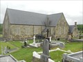 view gallery view galleryNW43 km | St. Agatha's Church - Clar, Ireland in This Old Church St. Agatha’s Church is a Catholic church in Clar, Donegal Town, Ireland. posted by: Marine Biologist location: Ulster, Ireland date approved: 07/29/2012 last visited: never |
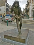 view gallery view galleryW43.1 km |  Rory Gallagher Statue - Ballyshannon Rory Gallagher Statue - Ballyshannon
in Musician Statues On 2 June 2010, a life-sized bronze statue of Rory Gallagher was unveiled in the town centre of Ballyshannon. posted by: cache-amount location: Ulster, Ireland date approved: 07/21/2013 last visited: never |
|