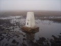
 view gallery view gallery SE1.9 km SE1.9 km
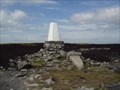
|   The Edge The Edge
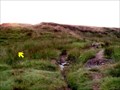
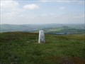
in U.K. and Ireland Trigpoints The Edge Trigpoint just off the Pennine Way on Kinder Scout in the Peak District. posted by:  theblack theblack location: United Kingdom date approved: 12/10/2007 last visited: 03/23/2012 |
 view gallery view gallery NE2.9 km NE2.9 km
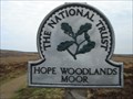
|  Hope Woodlands Moor, Derbyshire. Hope Woodlands Moor, Derbyshire.
in National Trust U.K. Glorious open moorland, high in the Derbyshire Peaks. Access here is from A57 Snake Pass, Glossop to Sheffield. posted by:  GeoRams GeoRams location: United Kingdom date approved: 04/13/2009 last visited: 09/24/2017 |
 view gallery view gallery S4.2 km S4.2 km
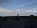
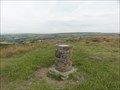
| KINDER LOW TRIG PILLAR (PEAK DISTRICT) in U.K. and Ireland Trigpoints Kinder Low trig pillar is the Peak Districts highest trig pillar. posted by: Grimspound & Jem location: United Kingdom date approved: 09/05/2006 last visited: 07/05/2013 |
 view gallery view galleryNE4.2 km | Higher Shelfstones in U.K. and Ireland Trigpoints Higher Shelfstones Trigpoint in the Dark Peak above Glossop. posted by: theblack location: United Kingdom date approved: 12/10/2007 last visited: 06/20/2017 |
 view gallery view galleryNE4.3 km |  On a wing and a prayer On a wing and a prayer
in Plane Crash Sites An interesting waymark that takes you to one of many aircraft crash sites in the Peak District. posted by: Itinerant Meggie location: United Kingdom date approved: 12/21/2005 last visited: 07/31/2020 |
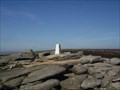
 view gallery view gallerySE4.7 km |  Kinder Low Kinder Low
in Mountain Summits Kinder Scout is a moorland plateau (and mountain) in the Dark Peak of the Derbyshire Peak District in England posted by: grufftymilo location: North West England, United Kingdom date approved: 07/07/2010 last visited: 10/31/2014 |
 view gallery view gallery E4.8 km E4.8 km
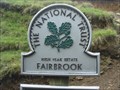
| Fairbrook, High Peak Estate, Derbyshire, England in National Trust U.K. Fairbrook, is part of the High Peak Estate. Fairbrook Naze is a steep path up from the A57 Snake Pass on to Kinder Scout. Starts opposite the Snake Inn. posted by: GeoRams location: United Kingdom date approved: 09/06/2009 last visited: 05/06/2011 |
 view gallery view gallery SW5 km SW5 km
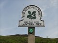
|  Lantern Pike - Hayfield, UK Lantern Pike - Hayfield, UK
in Wikipedia Entries Lantern Pike is a 373 metre high hill in the Peak District National Park. posted by: dtrebilc location: East Midlands, United Kingdom date approved: 09/29/2019 last visited: never |
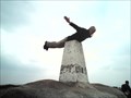
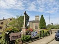
 view gallery view gallerySW5 km |  Edwin Royce Memorial Orientation Table - Hayfield, UK Edwin Royce Memorial Orientation Table - Hayfield, UK
in Citizen Memorials This orientation table marking the highest point on Lantern Pike in the Peak District National Park was erected in commemoration of Edwin Royce who campaigned for public access to the areas of the UK countryside. posted by: dtrebilc location: East Midlands, United Kingdom date approved: 10/01/2019 last visited: never |
 view gallery view gallerySW5 km |  Lantern Pike - Hayfield, UK Lantern Pike - Hayfield, UK
in Orientation Tables This orientation table is at the top of a hill called Lantern Pike that is owned by the National Trust and lies within the boundary of the Peak District National Park. posted by: dtrebilc location: East Midlands, United Kingdom date approved: 09/29/2019 last visited: never |
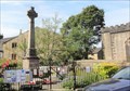 view gallery view gallerySW5.1 km |  Memorial Cross - Hayfield, UK Memorial Cross - Hayfield, UK
in World War I Memorials and Monuments This memorial cross was erected in in 1926 to commemorate the men of Hayfield that died in the First World War.
After the second World War a further memorial tablet was added for that war. posted by: dtrebilc location: East Midlands, United Kingdom date approved: 09/28/2019 last visited: never |
 view gallery view gallerySW5.1 km |  War Memorial Cross Hayfield, UK War Memorial Cross Hayfield, UK
in Christian Crosses This memorial cross was erected in in 1926 to commemorate the men of Hayfield that died in the First World War. posted by: dtrebilc location: East Midlands, United Kingdom date approved: 09/28/2019 last visited: never |
 view gallery view gallery N5.1 km N5.1 km
| Cock Hill in U.K. and Ireland Trigpoints Cock Hill Trigpoint in the Peak District above Glossop. posted by: theblack location: United Kingdom date approved: 12/10/2007 last visited: never |
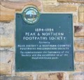 view gallery view gallerySW5.1 km |  Peak & Northern Footpaths Society - 100 Years - Hayfield, UK Peak & Northern Footpaths Society - 100 Years - Hayfield, UK
in Commercial Commemorations This commemorative plaque is on the wall of the visitor centre at Hayfield in the Peak District National Park. posted by: dtrebilc location: North East England, United Kingdom date approved: 01/09/2021 last visited: never |
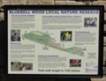 view gallery view gallerySW5.1 km |  Bluebell Woods - Hayfield, UK Bluebell Woods - Hayfield, UK
in Flora and Fauna Information Signs This information board is on the wall of Hayfield visitor centre and describes the flora and fauna in a nearby Local Nature Reserve. posted by: dtrebilc location: North East England, United Kingdom date approved: 01/05/2021 last visited: never |
 view gallery view gallerySW5.3 km | Lantern Pike - Hayfield, UK in National Trust U.K. Lantern Pike is a 373 metre high hill in the Peak District National Park. posted by: dtrebilc location: East Midlands, United Kingdom date approved: 10/01/2019 last visited: never |
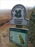 view gallery view gallerySE6.1 km | Crowden Clough - Edale, Derbyshire in National Trust U.K. NT marker at ther boundary to Crowden Clough, Edale, in the Peak District. posted by: SMacB location: East Midlands, United Kingdom date approved: 02/25/2015 last visited: never |
 view gallery view galleryS6.1 km | Brown Knoll in U.K. and Ireland Trigpoints Brown Knoll Trigpoint above Edale in the Peak District. posted by: theblack location: United Kingdom date approved: 12/29/2007 last visited: 09/27/2014 |
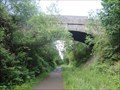 view gallery view gallery NW6.6 km NW6.6 km
|  Arch Road Bridge Over Longdendale Trail - Padfield, UK Arch Road Bridge Over Longdendale Trail - Padfield, UK
in Stone Bridges This single arch bridge carries Padfield MainRoad over the Longdendale Trail, a 'rails to trails' cycle, pedestrian and horse path. posted by: dtrebilc location: East Midlands, United Kingdom date approved: 07/15/2018 last visited: never |
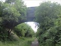 view gallery view galleryNW6.6 km |  Road Bridge Over Longdendale Trail - Padfield, UK Road Bridge Over Longdendale Trail - Padfield, UK
in Arch Bridges This single arch bridge carries Padfield Main Road over the Longdendale Trail, a 'rails to trails' cycle, pedestrian and horse path. posted by: dtrebilc location: East Midlands, United Kingdom date approved: 06/21/2018 last visited: never |
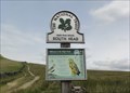 view gallery view galleryS6.8 km | High Peak Estate - South Head, UK in National Trust U.K. The High Peak Estate is an area of Pennine moorland in the ownership of the National Trust in the Dark Peak area of Derbyshire, England. posted by: dtrebilc location: East Midlands, United Kingdom date approved: 10/12/2019 last visited: never |
 view gallery view galleryNW6.8 km |  Spinners Arms, 1 Marsden Street - Hadfield, UK Spinners Arms, 1 Marsden Street - Hadfield, UK
in Pictorial Pub Signs The picture on this pub sign shows a hand spinning machine. posted by: dtrebilc location: East Midlands, United Kingdom date approved: 06/23/2018 last visited: never |
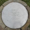
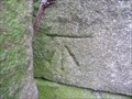 view gallery view gallerySE6.8 km |  Benchmark - Upper Booth, Derbyshire Benchmark - Upper Booth, Derbyshire
in European Historic Survey Stones, Monuments and Benchmarks Cut benchmark on side of farm building, Pennine Way, Upper Booth, Derbyshire. posted by: SMacB location: East Midlands, United Kingdom date approved: 02/17/2015 last visited: never |
 view gallery view gallerySE6.8 km | Benchmark - Upper Booth, Derbyshire in U.K. and Ireland Trigpoints Cut benchmark on side of farm building, Pennine Way, Upper Booth, Derbyshire. posted by: SMacB location: East Midlands, United Kingdom date approved: 02/16/2015 last visited: never |
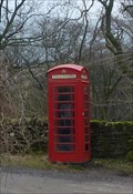 view gallery view gallerySE6.8 km |  Red Telephone Box - Upper Booth, Derbyshire Red Telephone Box - Upper Booth, Derbyshire
in Red Telephone Boxes Red telephone box on the Pennine Way, Upper Brook, at the entrance to Upper Brook farm. posted by: SMacB location: East Midlands, United Kingdom date approved: 02/16/2015 last visited: never |
|