 view gallery view gallery SE1.3 km SE1.3 km
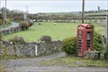
|   Red Telephone Box - Llanwrog, Anglesey, LL65 4PB Red Telephone Box - Llanwrog, Anglesey, LL65 4PB
in Red Telephone Boxes Empty box with lots of ivy and a political poster inside posted by:  thek6project thek6project location: North Wales, United Kingdom date approved: 04/03/2020 last visited: 03/19/2020 |
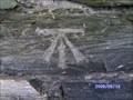
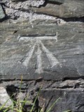
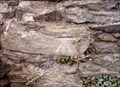
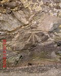
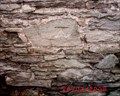
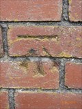 view gallery view gallerySE2.4 km |  Cut Mark - Pont Dronwy, Llanfachraeth, Ynys Môn, Wales Cut Mark - Pont Dronwy, Llanfachraeth, Ynys Môn, Wales
in U.K. and Ireland Trigpoints Cut mark: On SW face buttress bridge NE side of the road and NW side of stream, Llanfachraeth, Ynys Môn, Wales. posted by: Meirion location: North Wales, United Kingdom date approved: 07/14/2010 last visited: never |
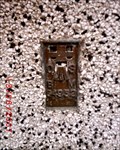
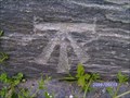
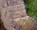
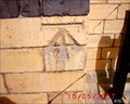
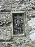 view gallery view gallerySE2.7 km | Llanfachraeth, St. Machraeth's Church in U.K. and Ireland Trigpoints Flush Bracket: 0n E face buttress of St. Machraeth's Church 6.8m from SE angle, Llanfachraeth, Ynys Môn. posted by: Meirion location: North Wales, United Kingdom date approved: 07/14/2010 last visited: never |
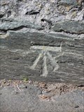
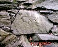
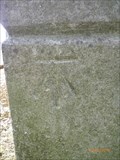 view gallery view gallerySE3.1 km | Llanfachraeth, Capel Abarim in U.K. and Ireland Trigpoints Cut mark: NE angle of N face of Capel Abarim, Llanfachraeth, Ynys Môn. posted by: Meirion location: North Wales, United Kingdom date approved: 07/14/2010 last visited: never |
 view gallery view gallery E3.5 km E3.5 km
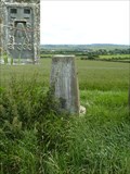
|  Triangulation Pillar - Graianfryn, Llanfachraeth, Ynys Môn, Wales Triangulation Pillar - Graianfryn, Llanfachraeth, Ynys Môn, Wales
in European Historic Survey Stones, Monuments and Benchmarks An Ordnance Survey triangulation pillar located in a field near Llanfachraeth, Ynys Môn, Wales. posted by: Meirion location: North Wales, United Kingdom date approved: 12/02/2011 last visited: never |
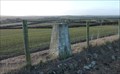 view gallery view galleryE3.5 km | Graianfryn - Anglesey, North Wales, UK in U.K. and Ireland Trigpoints A concrete trig pillar in good condition. posted by: Superted location: North Wales, United Kingdom date approved: 03/14/2010 last visited: 07/13/2010 |
 view gallery view gallery S4.5 km S4.5 km
| Newlands Park, Tabor hall in U.K. and Ireland Trigpoints Flush Bracket: on Tabor Hall SW angle S face, Newlands Park, Ynys Môn. posted by: Meirion location: North Wales, United Kingdom date approved: 06/13/2007 last visited: never |
 view gallery view gallery SW4.5 km SW4.5 km
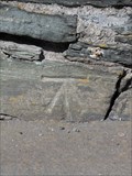
| Holyhead, Turkey Shore Road in U.K. and Ireland Trigpoints Cut mark: At all junction NW side Turkey Shore Road SE face, Holyhead, Ynys Môn. posted by: Meirion location: North Wales, United Kingdom date approved: 05/14/2009 last visited: never |
 view gallery view gallerySW4.5 km | Cut Mark - Turkey Shore Road, Holyhead, Ynys Môn, Wales in European Historic Survey Stones, Monuments and Benchmarks An Ordnance Survey benchmark on Turkey Shore Road, Holyhead, Ynys Môn, Wales. posted by: Meirion location: North Wales, United Kingdom date approved: 09/10/2012 last visited: never |
 view gallery view gallerySW4.7 km | Cut Mark - Turkey Shore Road#2, Holyhead, Ynys Môn, Wales in European Historic Survey Stones, Monuments and Benchmarks An Ordnance Survey benchmark on Turkey Shore Road, Holyhead, Ynys Môn, Wales. posted by: Meirion location: North Wales, United Kingdom date approved: 09/10/2012 last visited: never |
 view gallery view gallerySW4.7 km | Holyhead, Turkey Shore Road #2 in U.K. and Ireland Trigpoints Cut mark: On wall NW side Turkey Shore Road, Holyhead, Ynys Môn. posted by: Meirion location: North Wales, United Kingdom date approved: 05/16/2009 last visited: never |
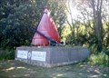 view gallery view gallerySW4.7 km |  Holyhead, Croeso i Caergybi / Welcome to Holyhead Holyhead, Croeso i Caergybi / Welcome to Holyhead
in Anchors The welcome sign / anchor on the way into Holyhead, Ynys Môn, Wales. posted by: Meirion location: North Wales, United Kingdom date approved: 06/06/2007 last visited: never |
 view gallery view gallerySW4.8 km | Holyhead, Turkey Shore Road #3 in U.K. and Ireland Trigpoints Cut mark: On wall NW side Turkey Shore Road, Holyhead, Ynys Môn. posted by: Meirion location: North Wales, United Kingdom date approved: 05/16/2009 last visited: never |
 view gallery view gallerySW4.8 km | Holyhead, Ffordd Tudor in U.K. and Ireland Trigpoints Rivet: On all W side Ffordd Tudor N side entrance garages, Holyhead, Ynys Môn. posted by: Meirion location: North Wales, United Kingdom date approved: 02/20/2008 last visited: never |
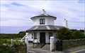 view gallery view galleryS4.8 km |  Tollhouse - Stanley Embankment, Penrhos, Ynys Môn, Wales Tollhouse - Stanley Embankment, Penrhos, Ynys Môn, Wales
in Bygone Toll Houses A tollhouse in Penrhos, Ynys Môn, Wales. posted by: Meirion location: North Wales, United Kingdom date approved: 05/13/2009 last visited: never |
 view gallery view gallerySW4.8 km | Holyhead, Vicarage Lane in U.K. and Ireland Trigpoints Cut mark: On wall 2.7m NW projection SE face house NE side of Vicarage Lane, Holyhead, Ynys Môn. posted by: Meirion location: North Wales, United Kingdom date approved: 11/13/2007 last visited: never |
 view gallery view gallerySW4.8 km | Holyhead, Victoria Road Wall #2 in U.K. and Ireland Trigpoints Cut mark: On all SE side Victoria Road 28.7m NE projection NE side Water Street, Holyhead, Ynys Môn. posted by: Meirion location: North Wales, United Kingdom date approved: 02/20/2008 last visited: never |
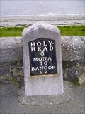 view gallery view galleryS4.8 km |  A5 milestone (Bangor 22), Stanley Embankment, Ynys Môn, Wales A5 milestone (Bangor 22), Stanley Embankment, Ynys Môn, Wales
in Milestones A Milestone situated along the A5, Stanley Embankment, Penrhos, Ynys Môn, Wales.
posted by: Meirion location: North Wales, United Kingdom date approved: 05/17/2009 last visited: never |
 view gallery view gallerySW4.8 km | Cut Mark - Turkey Shore Road#4, Holyhead, Ynys Môn, Wales in U.K. and Ireland Trigpoints Cut mark: On the NW side of Turkey Shore Road, Holyhead, Ynys Môn, Wales. posted by: Meirion location: North Wales, United Kingdom date approved: 09/10/2012 last visited: never |
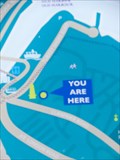 view gallery view gallerySW4.8 km |  YOU ARE HERE - Skinner's Monument, Holyhead, Ynys Môn, Wales YOU ARE HERE - Skinner's Monument, Holyhead, Ynys Môn, Wales
in 'You Are Here' Maps A YOU ARE HERE map in Holyhead, Ynys Môn, Wales. posted by: Meirion location: North Wales, United Kingdom date approved: 09/11/2012 last visited: never |
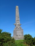 view gallery view gallerySW4.8 km |  Skinner's Monument, Holyhead, Anglesey, Wales Skinner's Monument, Holyhead, Anglesey, Wales
in Obelisks An obelisk overlooking the port on rocky outcrop above Holyhead, Ynys Môn, Wales. posted by: Meirion location: North Wales, United Kingdom date approved: 07/14/2007 last visited: 12/07/2014 |
 view gallery view gallerySW4.8 km | Holyhead, Victoria Road Wall #1 in U.K. and Ireland Trigpoints Cut mark: On wall SE side Victoria Road 8m NE projection wall, Holyhead, Ynys Môn. posted by: Meirion location: North Wales, United Kingdom date approved: 02/20/2008 last visited: never |
 view gallery view gallery W5 km W5 km
|  Holyhead Maritime Museum - Anglesey, Wales, UK Holyhead Maritime Museum - Anglesey, Wales, UK
in Maritime Museums The Holyhead Maritime Museum is housed in th oldest lifeboat station in Wales (circa. 1858). It has a collection of exhibits that tells the fascinating maritime history of Holyhead posted by: Superted location: North Wales, United Kingdom date approved: 03/17/2010 last visited: 04/07/2011 |
 view gallery view galleryW5 km | Holyhead, Maritime museum in Anchors Two anchors on display outside the Maritime museum, Holyhead, Ynys Môn, Wales. posted by: Meirion location: North Wales, United Kingdom date approved: 06/16/2007 last visited: 04/07/2011 |
 view gallery view gallerySW5 km | Holyhead, Town hall in U.K. and Ireland Trigpoints Cut mark: W angle of town hall NE side Newry Street, Holyhead, Ynys Môn. posted by: Meirion location: North Wales, United Kingdom date approved: 05/15/2007 last visited: never |
|