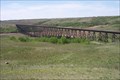
 view gallery view gallery NW21.6 km NW21.6 km
|   Battle River Railway Trestle - Alberta, Canada Battle River Railway Trestle - Alberta, Canada
in Railroad Bridges Battle River Railway Trestle. posted by:  klr4evr klr4evr location: Alberta, Canada date approved: 10/23/2011 last visited: 06/21/2013 |
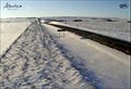 view gallery view gallery E50.5 km E50.5 km
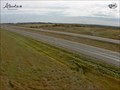
|  Wainwright West Highway Web Camera - Wainwright, Alberta Wainwright West Highway Web Camera - Wainwright, Alberta
in Web Cameras This Alberta Highways Webcam is mounted on a steel tower on the south side of Highway 14 near the Alberta-Saskatchewan border. posted by: T0SHEA location: Alberta, Canada date approved: 03/03/2014 last visited: 07/30/2014 |
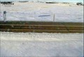 view gallery view galleryE50.5 km | Wainwright Road Highway Web Camera - Wainwright, Alberta in Web Cameras This Alberta Highways Webcam is mounted on a steel tower on the south side of Highway 14 near the Alberta-Saskatchewan border. posted by: T0SHEA location: Alberta, Canada date approved: 03/03/2014 last visited: 07/30/2014 |
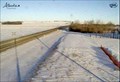 view gallery view galleryE50.5 km | Wainwright East Highway Web Camera - Wainwright, Alberta in Web Cameras This Alberta Highways Webcam is mounted on a steel tower on the south side of Highway 14 near the Alberta-Saskatchewan border. posted by: T0SHEA location: Alberta, Canada date approved: 03/03/2014 last visited: 07/30/2014 |
 view gallery view galleryE51.7 km |  Saskatchewan / Alberta Provincial Border crossing #3 Saskatchewan / Alberta Provincial Border crossing #3
in Border Crossings Another border crossing between Wainwright, Alberta and Marsden, Saskatchewan. posted by:  StagsRoar StagsRoar location: Saskatchewan, Canada date approved: 06/04/2006 last visited: never |
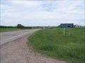
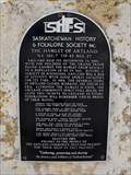 view gallery view galleryE59.2 km |  Hamlet of Artland Hamlet of Artland
in Saskatchewan Historical Markers Located approximately 18 Km South of Highway 40. posted by: Altima Voyageur location: Saskatchewan, Canada date approved: 04/16/2014 last visited: never |
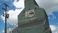 view gallery view gallery N60.8 km N60.8 km
|  Alberta Wheat Pool Elevator - Claysmore, Alberta Alberta Wheat Pool Elevator - Claysmore, Alberta
in Ghost Signs Claysmore, the town, is pretty much gone now. So is the Claysmore elevator - gone down the road to a farm just south of Vermilion. It's visible to the south from the Yellowhead Highway as one passes Vermilion. posted by: T0SHEA location: Saskatchewan, Canada date approved: 02/07/2013 last visited: 12/31/2013 |
 view gallery view galleryN60.8 km |  Alberta Wheat Pool Elevator - Claysmore, Alberta Alberta Wheat Pool Elevator - Claysmore, Alberta
in Grain Elevators Claysmore, the town, is pretty much gone now. So is the Claysmore elevator - gone down the road to a farm just south of Vermilion. It's visible to the south from the Yellowhead Highway as one passes Vermilion. posted by: T0SHEA location: Alberta, Canada date approved: 02/07/2013 last visited: 12/31/2013 |
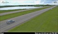 view gallery view galleryN62.4 km | Vermilion West Traffic Webcam - Vermilion, AB in Web Cameras This is an Alberta Highways Webcam on Hiway 16, Near Vermilion and East of Highway 41. posted by: T0SHEA location: Alberta, Canada date approved: 06/27/2016 last visited: 12/18/2018 |
 view gallery view galleryN62.4 km | Vermilion East Traffic Webcam - Vermilion, AB in Web Cameras Hiway 16, Near Vermilion and East of Hiway 41. posted by: T0SHEA location: Alberta, Canada date approved: 11/06/2013 last visited: 05/29/2014 |
 view gallery view galleryN62.4 km | Vermilion South Traffic Webcam - Vermilion, AB in Web Cameras This is an Alberta Highways Webcam on Hiway 16, Near Vermilion and East of Highway 41. posted by: T0SHEA location: Alberta, Canada date approved: 06/27/2016 last visited: never |
 view gallery view galleryN63.4 km | Vermillion Elevator - Alberta, Canada in Grain Elevators Now a private elevator. posted by: T0SHEA location: Alberta, Canada date approved: 09/07/2012 last visited: 01/11/2014 |
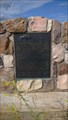
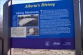 view gallery view galleryNW63.4 km |  Viking Ribstones Viking Ribstones
in Alberta Heritage Markers Viking Ribstones Provincial Historical Marker posted by: klr4evr location: Alberta, Canada date approved: 10/23/2011 last visited: never |
 view gallery view galleryE66 km | Manitou Lake Picnic Grounds in Saskatchewan Historical Markers This is located about 6 km Southeast of Marsden Sask in the Regional Park. posted by: Altima Voyageur location: Saskatchewan, Canada date approved: 06/26/2013 last visited: never |
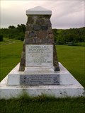
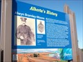 view gallery view gallery NE68.1 km NE68.1 km
| Alwyn Bramley-Moore in Alberta Heritage Markers Alwyn Bramley-Moore on Hwy 16, east of Kitscoty, Ab posted by: yellowmojo location: Alberta, Canada date approved: 08/30/2011 last visited: 12/24/2013 |
 view gallery view galleryNE68.1 km | Lloydminster Traffic Webcam - Lloydminster, AB in Web Cameras Hiway 16, Near Lloydminster and East of Hiway 897. posted by: T0SHEA location: Alberta, Canada date approved: 11/06/2013 last visited: 05/26/2014 |
 view gallery view gallery S68.9 km S68.9 km
| The Neutral Hills in Alberta Heritage Markers This cairn is 34 kilometers south of Czar on north side of Buffalo Trail (Hwy 41). Look for Historic signs. posted by: Altima Voyageur location: Alberta, Canada date approved: 09/09/2017 last visited: never |
 view gallery view gallery SE69.5 km SE69.5 km
| Saskatchewan / Alberta Provincial Border crossing #2 in Border Crossings This provincial crossing is between Macklin, Saskatchewan and Provost, Alberta. posted by: StagsRoar location: Saskatchewan, Canada date approved: 06/04/2006 last visited: 06/10/2007 |
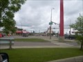
 view gallery view galleryNE72.3 km |  Buffalo Twins - Lloydminster, AB Buffalo Twins - Lloydminster, AB
in Mosaics Here is a huge mosaic that totally blew us away. In the area of Lloydminster, AB/SK, this is an absolute must see. posted by: T0SHEA location: Alberta, Canada date approved: 12/29/2012 last visited: 02/13/2014 |
 view gallery view galleryNE72.3 km |  Buffalo Twins - Lloydminster, AB Buffalo Twins - Lloydminster, AB
in Murals Here is a huge mural that totally blew us away. In the area of Lloydminster, AB/SK, this is an absolute must see. posted by: T0SHEA location: Alberta, Canada date approved: 12/29/2012 last visited: 02/12/2014 |
 view gallery view gallerySE74.4 km | The History of Bunnock in Saskatchewan Historical Markers Located at junction of Hwy 31 and 14. posted by: Altima Voyageur location: Saskatchewan, Canada date approved: 06/19/2013 last visited: never |
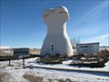 view gallery view gallerySE74.4 km |  Giant Bunnock - Macklin, Saskatchewan Giant Bunnock - Macklin, Saskatchewan
in Roadside Attractions This is a giant bunnock, a scaled up version of a bone that is used in a game that was first introduced to Canada by Russian Germans. The world championship is hosted and played in Macklin, Saskatchewan. posted by: wildwoodke location: Saskatchewan, Canada date approved: 02/22/2012 last visited: never |
 view gallery view gallerySE74.4 km |  Home of the World Bunnock Championship - Macklin, Saskatchewan Home of the World Bunnock Championship - Macklin, Saskatchewan
in Welcome Signs The welcome sign speaks to the sport, that one might relate to horseshoes, that is played in the Town of Macklin, Saskatchewan. posted by: wildwoodke location: Saskatchewan, Canada date approved: 03/01/2012 last visited: never |
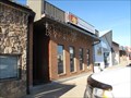 view gallery view gallerySE75.2 km |  Peking Garden Family Restaurant - Macklin, Saskatchewan Peking Garden Family Restaurant - Macklin, Saskatchewan
in Chinese Restaurants This Chinese (and Western) cuisine is one of the few restaurants in the town of Macklin, Saskatchewan. posted by: wildwoodke location: Saskatchewan, Canada date approved: 03/01/2012 last visited: never |
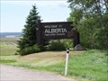
 view gallery view galleryNE75.2 km | Saskatchewan / Alberta Provincial Border crossing #1 in Border Crossings One of the view borders anywhere that actually cuts a town in half - that of the town of Lloydminster. posted by: StagsRoar location: Saskatchewan, Canada date approved: 05/27/2006 last visited: 08/29/2018 |
|