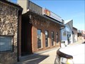
 view gallery view gallery SW0.3 km SW0.3 km
|   Peking Garden Family Restaurant - Macklin, Saskatchewan Peking Garden Family Restaurant - Macklin, Saskatchewan
in Chinese Restaurants This Chinese (and Western) cuisine is one of the few restaurants in the town of Macklin, Saskatchewan. posted by:  wildwoodke wildwoodke location: Saskatchewan, Canada date approved: 03/01/2012 last visited: never |
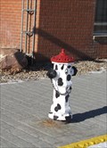 view gallery view gallerySW0.5 km |  Dalmation hydrant - Macklin, Saskatchewan Dalmation hydrant - Macklin, Saskatchewan
in Painted Hydrants This dalmation fire hydrant is located on Main Street in Macklin Saskatchewan. posted by: wildwoodke location: Saskatchewan, Canada date approved: 03/15/2012 last visited: never |
 view gallery view gallery N1.4 km N1.4 km
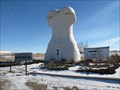
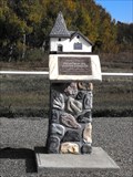
|  Giant Bunnock - Macklin, Saskatchewan Giant Bunnock - Macklin, Saskatchewan
in Roadside Attractions This is a giant bunnock, a scaled up version of a bone that is used in a game that was first introduced to Canada by Russian Germans. The world championship is hosted and played in Macklin, Saskatchewan. posted by: wildwoodke location: Saskatchewan, Canada date approved: 02/22/2012 last visited: never |
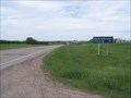
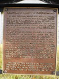
 view gallery view galleryN1.4 km |  Home of the World Bunnock Championship - Macklin, Saskatchewan Home of the World Bunnock Championship - Macklin, Saskatchewan
in Welcome Signs The welcome sign speaks to the sport, that one might relate to horseshoes, that is played in the Town of Macklin, Saskatchewan. posted by: wildwoodke location: Saskatchewan, Canada date approved: 03/01/2012 last visited: never |
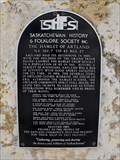
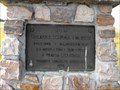
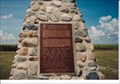
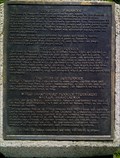 view gallery view galleryN1.6 km |  The History of Bunnock The History of Bunnock
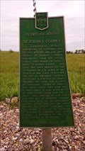
in Saskatchewan Historical Markers Located at junction of Hwy 31 and 14. posted by: Altima Voyageur location: Saskatchewan, Canada date approved: 06/19/2013 last visited: never |
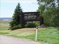 view gallery view gallery NW5.6 km NW5.6 km
|  Saskatchewan / Alberta Provincial Border crossing #2 Saskatchewan / Alberta Provincial Border crossing #2
in Border Crossings This provincial crossing is between Macklin, Saskatchewan and Provost, Alberta. posted by: StagsRoar location: Saskatchewan, Canada date approved: 06/04/2006 last visited: 06/10/2007 |
 view gallery view galleryN40.2 km | Hamlet of Artland in Saskatchewan Historical Markers Located approximately 18 Km South of Highway 40. posted by: Altima Voyageur location: Saskatchewan, Canada date approved: 04/16/2014 last visited: never |
 view gallery view galleryN52.8 km | Manitou Lake Picnic Grounds in Saskatchewan Historical Markers This is located about 6 km Southeast of Marsden Sask in the Regional Park. posted by: Altima Voyageur location: Saskatchewan, Canada date approved: 06/26/2013 last visited: never |
 view gallery view galleryN56.6 km | Saskatchewan / Alberta Provincial Border crossing #3 in Border Crossings Another border crossing between Wainwright, Alberta and Marsden, Saskatchewan. posted by: StagsRoar location: Saskatchewan, Canada date approved: 06/04/2006 last visited: never |
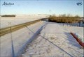 view gallery view galleryN56.8 km |  Wainwright East Highway Web Camera - Wainwright, Alberta Wainwright East Highway Web Camera - Wainwright, Alberta
in Web Cameras This Alberta Highways Webcam is mounted on a steel tower on the south side of Highway 14 near the Alberta-Saskatchewan border. posted by:  T0SHEA T0SHEA location: Alberta, Canada date approved: 03/03/2014 last visited: 07/30/2014 |
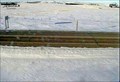 view gallery view galleryN56.8 km | Wainwright Road Highway Web Camera - Wainwright, Alberta in Web Cameras This Alberta Highways Webcam is mounted on a steel tower on the south side of Highway 14 near the Alberta-Saskatchewan border. posted by: T0SHEA location: Alberta, Canada date approved: 03/03/2014 last visited: 07/30/2014 |
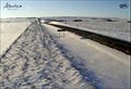 view gallery view galleryN56.8 km | Wainwright West Highway Web Camera - Wainwright, Alberta in Web Cameras This Alberta Highways Webcam is mounted on a steel tower on the south side of Highway 14 near the Alberta-Saskatchewan border. posted by: T0SHEA location: Alberta, Canada date approved: 03/03/2014 last visited: 07/30/2014 |
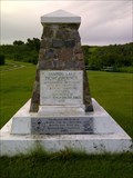
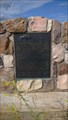 view gallery view gallery W64.1 km W64.1 km
|  The Neutral Hills The Neutral Hills
in Alberta Heritage Markers This cairn is 34 kilometers south of Czar on north side of Buffalo Trail (Hwy 41). Look for Historic signs. posted by: Altima Voyageur location: Alberta, Canada date approved: 09/09/2017 last visited: never |
 view gallery view gallery NE68.4 km NE68.4 km
| Wilburt School in Saskatchewan Historical Markers Located on Hwy 21. posted by: Altima Voyageur location: Saskatchewan, Canada date approved: 10/14/2013 last visited: never |
 view gallery view galleryNE70.7 km | Swarthmore Colony of Friends (Quakers) in Saskatchewan Historical Markers Located South of grid road Hwy 787. posted by: Altima Voyageur location: Saskatchewan, Canada date approved: 10/14/2013 last visited: never |
 view gallery view galleryNE70.7 km | Swarthmore United Church in Saskatchewan Historical Markers Located South of grid road Hwy 787. posted by: Altima Voyageur location: Saskatchewan, Canada date approved: 10/14/2013 last visited: never |
 view gallery view galleryNE77.6 km | Poundmaker Cairn (Town of Cutknife) in Saskatchewan Historical Markers This Cairn is located just of the highway on the main street into Cutknife in the centre of the boulevard. posted by: Altima Voyageur location: Saskatchewan, Canada date approved: 10/08/2012 last visited: never |
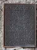 view gallery view galleryNE80.1 km | The Big Rock Landmark in Saskatchewan Historical Markers This is a nice picnicking area. Just Southeast of Cut Knife. posted by: Altima Voyageur location: Saskatchewan, Canada date approved: 10/15/2013 last visited: never |
 view gallery view galleryNE81.9 km | Lilydale Bridge in Saskatchewan Historical Markers Located South of the Bridge, East side of hwy. posted by: Altima Voyageur location: Saskatchewan, Canada date approved: 12/08/2011 last visited: never |
 view gallery view gallery E85.3 km E85.3 km
| The Trampling Lake Portion of the Medicine Hat Trail in Saskatchewan Historical Markers Located on the Northeast side of Wilkie. posted by: Altima Voyageur location: Saskatchewan, Canada date approved: 08/31/2014 last visited: never |
 view gallery view galleryE85.6 km | St. Joseph's Colony in Saskatchewan Historical Markers Located about 10 Kilometers South from Highway 14. Meters East of Grid Hwy 657. posted by: Altima Voyageur location: Saskatchewan, Canada date approved: 08/31/2014 last visited: never |
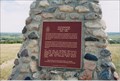
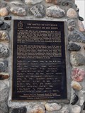 view gallery view galleryNE86.7 km | The Battle of Cut Knife/La Bataille de Cut Knife/Poundmaker in Saskatchewan Historical Markers Located on the Poundmaker First Nation, this is a Historic site that is open during the summer months. posted by: Altima Voyageur location: Saskatchewan, Canada date approved: 10/15/2013 last visited: never |
 view gallery view galleryNE86.7 km |  CNHS he Battle of Cut Knife - La Bataille de Cut Knife CNHS he Battle of Cut Knife - La Bataille de Cut Knife
in Canadian National Historic Sites Located together with Chief Poundmaker. This cairn is located on the Poundmaker First Nation, this is a Historic site that is open during the summer months. posted by: Altima Voyageur location: Saskatchewan, Canada date approved: 11/16/2017 last visited: never |
 view gallery view galleryNE86.7 km | CNHP Poundmaker 1842-1886 in Canadian National Historic Sites Located on the Poundmaker First Nation, this is a Historic site that is open during the summer months. posted by: Altima Voyageur location: Saskatchewan, Canada date approved: 11/16/2017 last visited: never |
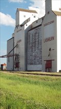 view gallery view galleryN90.6 km |  Saskatchewan Wheat Pool Elevator, Lashburn, Saskatchewan Saskatchewan Wheat Pool Elevator, Lashburn, Saskatchewan
in Grain Elevators Lashburn is about 34 km.south east of Lloydminster, AB/SK, on the Yellowhead Highway - aka Highway 16. posted by: T0SHEA location: Saskatchewan, Canada date approved: 02/01/2013 last visited: 06/29/2015 |
|