 view gallery view gallery NE28.3 km NE28.3 km
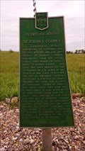
|   St. Joseph's Colony St. Joseph's Colony
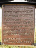
in Saskatchewan Historical Markers Located about 10 Kilometers South from Highway 14. Meters East of Grid Hwy 657. posted by:  Altima Voyageur Altima Voyageur location: Saskatchewan, Canada date approved: 08/31/2014 last visited: never |
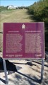
 view gallery view galleryNE45.9 km | The Trampling Lake Portion of the Medicine Hat Trail in Saskatchewan Historical Markers Located on the Northeast side of Wilkie. posted by: Altima Voyageur location: Saskatchewan, Canada date approved: 08/31/2014 last visited: never |
 view gallery view gallery S47.5 km S47.5 km
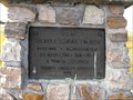
| Addison Sod House (National Site) in Saskatchewan Historical Markers Both a Provincial and National Site Addison Sod House historic site is a house that was built over a hundred years ago and is still a habitable home. Located north of Kindersley on Hwy 21, then East on Gleneath Road, 10.6 kilometers. posted by: Altima Voyageur location: Saskatchewan, Canada date approved: 09/16/2017 last visited: never |
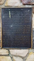
 view gallery view galleryS47.5 km |  CNHS Addison House CNHS Addison House
in Canadian National Historic Sites National Historic Site Addison Sod House, is a house that was built over a hundred years ago and is still a habitable home. Located north of Kindersley on Hwy 21, then East on Gleneath Road, 10.6 kilometers. posted by: Altima Voyageur location: Saskatchewan, Canada date approved: 09/20/2017 last visited: never |
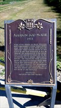 view gallery view galleryS47.5 km | Addison Sod House (Provincial Site) in Saskatchewan Historical Markers Both and provincial and national site the Addison Sod House has lasted over a hundred years. Located north of Kindersley on Hwy 21, then East on Gleneath Road, 10.6 kilometers. posted by: Altima Voyageur location: Saskatchewan, Canada date approved: 09/16/2017 last visited: never |
 view gallery view gallery N59.2 km N59.2 km
| Swarthmore Colony of Friends (Quakers) in Saskatchewan Historical Markers Located South of grid road Hwy 787. posted by: Altima Voyageur location: Saskatchewan, Canada date approved: 10/14/2013 last visited: never |
 view gallery view galleryN59.2 km | Swarthmore United Church in Saskatchewan Historical Markers Located South of grid road Hwy 787. posted by: Altima Voyageur location: Saskatchewan, Canada date approved: 10/14/2013 last visited: never |
 view gallery view gallery SE62.4 km SE62.4 km
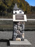
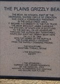
| The Plains Grizzly Bear in Saskatchewan Historical Markers Located in the small community of Herschel. posted by: Altima Voyageur location: Saskatchewan, Canada date approved: 04/12/2015 last visited: never |
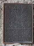 view gallery view galleryN63.4 km | The Big Rock Landmark in Saskatchewan Historical Markers This is a nice picnicking area. Just Southeast of Cut Knife. posted by: Altima Voyageur location: Saskatchewan, Canada date approved: 10/15/2013 last visited: never |
 view gallery view gallery NW72.9 km NW72.9 km
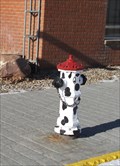
|  Dalmation hydrant - Macklin, Saskatchewan Dalmation hydrant - Macklin, Saskatchewan
in Painted Hydrants This dalmation fire hydrant is located on Main Street in Macklin Saskatchewan. posted by: wildwoodke location: Saskatchewan, Canada date approved: 03/15/2012 last visited: never |
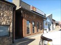 view gallery view galleryNW72.9 km |  Peking Garden Family Restaurant - Macklin, Saskatchewan Peking Garden Family Restaurant - Macklin, Saskatchewan
in Chinese Restaurants This Chinese (and Western) cuisine is one of the few restaurants in the town of Macklin, Saskatchewan. posted by: wildwoodke location: Saskatchewan, Canada date approved: 03/01/2012 last visited: never |
 view gallery view galleryNW73.2 km |  Home of the World Bunnock Championship - Macklin, Saskatchewan Home of the World Bunnock Championship - Macklin, Saskatchewan
in Welcome Signs The welcome sign speaks to the sport, that one might relate to horseshoes, that is played in the Town of Macklin, Saskatchewan. posted by: wildwoodke location: Saskatchewan, Canada date approved: 03/01/2012 last visited: never |
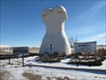 view gallery view galleryNW73.2 km |  Giant Bunnock - Macklin, Saskatchewan Giant Bunnock - Macklin, Saskatchewan
in Roadside Attractions This is a giant bunnock, a scaled up version of a bone that is used in a game that was first introduced to Canada by Russian Germans. The world championship is hosted and played in Macklin, Saskatchewan. posted by: wildwoodke location: Saskatchewan, Canada date approved: 02/22/2012 last visited: never |
 view gallery view galleryNW73.2 km | The History of Bunnock in Saskatchewan Historical Markers Located at junction of Hwy 31 and 14. posted by: Altima Voyageur location: Saskatchewan, Canada date approved: 06/19/2013 last visited: never |
 view gallery view galleryN75.5 km | Wilburt School in Saskatchewan Historical Markers Located on Hwy 21. posted by: Altima Voyageur location: Saskatchewan, Canada date approved: 10/14/2013 last visited: never |
 view gallery view gallery SW77.6 km SW77.6 km
| Buffalo Rubbing Stone (Near Flaxcombe) in Saskatchewan Historical Markers Located near the town Flaxcombe on Hwy 7. posted by: Altima Voyageur location: Saskatchewan, Canada date approved: 05/27/2017 last visited: never |
 view gallery view galleryN78.2 km | Poundmaker Cairn (Town of Cutknife) in Saskatchewan Historical Markers This Cairn is located just of the highway on the main street into Cutknife in the centre of the boulevard. posted by: Altima Voyageur location: Saskatchewan, Canada date approved: 10/08/2012 last visited: never |
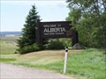 view gallery view galleryNW78.4 km |  Saskatchewan / Alberta Provincial Border crossing #2 Saskatchewan / Alberta Provincial Border crossing #2
in Border Crossings This provincial crossing is between Macklin, Saskatchewan and Provost, Alberta. posted by: StagsRoar location: Saskatchewan, Canada date approved: 06/04/2006 last visited: 06/10/2007 |
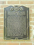 view gallery view galleryNE86.9 km | Battleford Land Registry Office in Saskatchewan Historical Markers This historical marker for the Battleford Land Registry Office is located on the building at Government Ridge in Battleford. posted by:  Marine Biologist Marine Biologist location: Saskatchewan, Canada date approved: 07/31/2013 last visited: never |
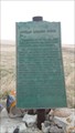
 view gallery view galleryNE86.9 km |  FIRST - Land Registry Office in Canada's North-West Territories FIRST - Land Registry Office in Canada's North-West Territories
in First of its Kind Not only is the Battleford Land Registry Office the first land registry office in the North-West Territories, but it is also the oldest known brick building in Saskatchewan. posted by: Marine Biologist location: Saskatchewan, Canada date approved: 07/30/2013 last visited: never |
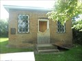
 view gallery view galleryNE86.9 km |  Battleford Land Registry Office - Battleford, SK Battleford Land Registry Office - Battleford, SK
in Western Canadian Heritage The Battleford Land Registry Office is located at Government Ridge in Battleford. posted by: Marine Biologist location: Saskatchewan, Canada date approved: 07/31/2013 last visited: never |
 view gallery view galleryNE86.9 km | 1877-1883 Government House Battleford in Saskatchewan Historical Markers Just as short drive up a hill then a quick switch back left turn to this location. posted by: Altima Voyageur location: Saskatchewan, Canada date approved: 06/18/2013 last visited: never |
 view gallery view galleryNE86.9 km | North-West Council Government House in Saskatchewan Historical Markers A short drive up the hill this Cairn is located just off Hwy 4 and 658 junction. posted by: Altima Voyageur location: Saskatchewan, Canada date approved: 09/27/2009 last visited: never |
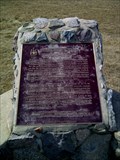 view gallery view galleryNE86.9 km | Seat of the Territorial Government National Historic Monument~Seige du Gouvernement Territorial , 1878-1883 in Saskatchewan Historical Markers Walking distance to other North West Territory Government House waymark. This plaque is in rough shape. posted by: Altima Voyageur location: Alberta, Canada date approved: 06/19/2013 last visited: never |
 view gallery view galleryNE86.9 km | CNHS Seat of the Territorial Government National Historic Monument~Seige du Gouvernement Territorial, 1878-1883 in Canadian National Historic Sites This is located a few kilometers southwest of the Town of Battleford. posted by: Altima Voyageur location: Saskatchewan, Canada date approved: 11/12/2017 last visited: never |
|