 view gallery view gallery SE0.5 km SE0.5 km
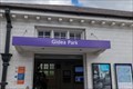
|   Gidea Park Railway Station - Station Road, London, UK Gidea Park Railway Station - Station Road, London, UK
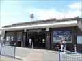
in Train Stations/Depots Gidea Park railway station handles services operated by Transport for London's Elizabeth Line. The tracks run in an east/west direction with entrances to the north and south connected by a covered foot bridge that gives access to the platforms. posted by:  Master Mariner Master Mariner location: London, United Kingdom date approved: 08/22/2022 last visited: never |
 view gallery view gallerySE0.5 km |  Gidea Park Railway Station - Station Road, London, UK Gidea Park Railway Station - Station Road, London, UK
in Wikipedia Entries Gidea Park railway station handles services operated by Transport for London's Elizabeth Line. The tracks run in an east/west direction with entrances to the north and south connected by a covered foot bridge that gives access to the platforms. posted by: Master Mariner location: London, United Kingdom date approved: 08/22/2022 last visited: never |
 view gallery view gallery W1.1 km W1.1 km
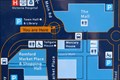
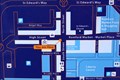
|  You Are Here - Town Hall Underpass, Romford, UK You Are Here - Town Hall Underpass, Romford, UK
in 'You Are Here' Maps This "you are here" is located at the centre of the junction of three pedestrian underpasses to the south of Havering Town Hall. posted by: Master Mariner location: London, United Kingdom date approved: 10/09/2017 last visited: never |
 view gallery view gallery SW1.4 km SW1.4 km
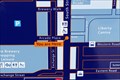
| You Are Here - South Street, Romford, UK in 'You Are Here' Maps This "you are here" map is in the centre of Romford's pedestrianised section of South Street at the junction with Arcade Place. posted by: Master Mariner location: London, United Kingdom date approved: 10/09/2017 last visited: never |
 view gallery view gallerySW1.4 km | You Are Here - South Street, Romford, UK in 'You Are Here' Maps This "you are here" map is in the centre of Romford's pedestrianised section of South Street at the junction with Brewery Walk. posted by: Master Mariner location: London, United Kingdom date approved: 10/09/2017 last visited: never |
 view gallery view galleryW1.4 km | You Are Here - South Street, Romford, UK in 'You Are Here' Maps This "you are here" map is on the south west side of South Street at the junction with Romford High Street and immediately opposite the Golden Lion public house. posted by: Master Mariner location: London, United Kingdom date approved: 10/09/2017 last visited: never |
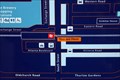 view gallery view gallerySW1.4 km | You Are Here - South Street, Romford, UK in 'You Are Here' Maps This "you are here" map is located on the south west side of South Street, outside Romford railway station, in Romford. posted by: Master Mariner location: London, United Kingdom date approved: 10/09/2017 last visited: never |
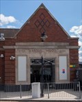
 view gallery view gallerySW1.4 km | Romford Railway Station - South Street, Romford, UK in Train Stations/Depots Romford railway station handles services operated by London Overground and Greater Anglia. The station entrance is located beneath a rail bridge and is on the south west side of South Street in Romford. posted by: Master Mariner location: London, United Kingdom date approved: 10/09/2017 last visited: 04/06/2021 |
 view gallery view gallerySW1.4 km | Romford Railway Station - South Street, Romford, UK in Wikipedia Entries Romford railway station handles services operated by London Overground and Greater Anglia. The station entrance is located beneath a rail bridge and is on the south west side of South Street in Romford. posted by: Master Mariner location: London, United Kingdom date approved: 10/09/2017 last visited: never |
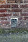
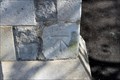
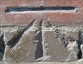
 view gallery view galleryW1.6 km |  Cut Bench Mark - North Street, Romford, London, UK Cut Bench Mark - North Street, Romford, London, UK
in U.K. and Ireland Trigpoints This mark is cut into the heavily painted brickwork of a building on the north east side of North Street. The mark is on the south west face of the building close to its west angle. posted by: Master Mariner location: London, United Kingdom date approved: 05/02/2017 last visited: never |
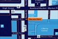
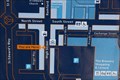 view gallery view gallerySW1.6 km | You Are Here - Romford High Street, Romford, UK in 'You Are Here' Maps This "you are here" map is located on the north west side of Romford High Street opposite the former Romford Brewery. posted by: Master Mariner location: London, United Kingdom date approved: 10/09/2017 last visited: never |
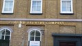 view gallery view gallerySW1.6 km |  Romford Brewery Company (closed) - East London Romford Brewery Company (closed) - East London
in Breweries Ind Coope & Co's old brewery building. posted by: Master Mariner location: London, United Kingdom date approved: 04/29/2011 last visited: 04/17/2021 |
 view gallery view gallerySW1.6 km | Flush Bracket - High Street, Romford, London, UK in U.K. and Ireland Trigpoints The flush bracket is attached a building on the south east side of the High Street in Romford. The bracket is on the north west side of the building close to the entrance to a former brewery. posted by: Master Mariner location: London, United Kingdom date approved: 04/30/2017 last visited: 04/17/2021 |
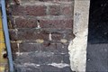 view gallery view gallerySW1.6 km | Cut Bench Mark - High Street, Romford, London, UK in U.K. and Ireland Trigpoints This mark is cut into the brickwork of a building located on the south east side of the High Street in Romford. The mark is on the north west face of the building at the building's west corner. posted by: Master Mariner location: London, United Kingdom date approved: 05/02/2017 last visited: never |
 view gallery view gallerySW1.8 km | You Are Here - Romford High Street, Romford, UK in 'You Are Here' Maps This "you are here" map is located on the north west side of Romford High Street at the junction with St Edward's Way. posted by: Master Mariner location: London, United Kingdom date approved: 10/09/2017 last visited: never |
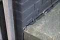 view gallery view gallerySW1.8 km | Cut Bench Mark - Waterloo Road, Romford, London, UK in U.K. and Ireland Trigpoints The mark is cut into brickwork of a wing of a railway bridge on the north east side of Waterloo Road. The mark is on the north west side of the bridge. posted by: Master Mariner location: London, United Kingdom date approved: 05/02/2017 last visited: never |
 view gallery view gallerySW1.9 km | Cut Bench Mark - St Andrew's Road, Romford, London, UK in U.K. and Ireland Trigpoints This mark is cut into a stone gatepost of St Andrew's church located on the south west side of St Andrew's Road at the junction with Queen Street. The mark is on the south east gatepost on its north west face. posted by: Master Mariner location: London, United Kingdom date approved: 05/02/2017 last visited: never |
 view gallery view gallerySW1.9 km | Cut Bench Mark - Cotleigh Road, Romford, London, UK in U.K. and Ireland Trigpoints This mark is cut into a stone wall on the east side of Cotleigh Road. The mark is cut into the northern gatepost of the entrance to St Andrew's Church. posted by: Master Mariner location: London, United Kingdom date approved: 05/02/2017 last visited: never |
 view gallery view gallery NE2.6 km NE2.6 km
| Harold Wood Railway Station - Gubbins Lane, London, UK in Train Stations/Depots The tracks that pass through Harold Wood station are for the Elizabeth Line and non-stopping trains operated by Greater Anglia. A flyover crosses the tracks to the west of the station and the main entrance and ticket office are at its north end. posted by: Master Mariner location: London, United Kingdom date approved: 08/22/2022 last visited: never |
 view gallery view galleryNE2.6 km | Harold Wood Railway Station - Gubbins Lane, London, UK in Wikipedia Entries The tracks that pass through Harold Wood station are for the Elizabeth Line and non-stopping trains operated by Greater Anglia. A flyover crosses the tracks to the west of the station and the main entrance and ticket office are at its north end. posted by: Master Mariner location: London, United Kingdom date approved: 08/22/2022 last visited: never |
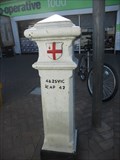 view gallery view gallerySW2.6 km |  Coal Tax Post 1 - Dagenham Road, Romford Coal Tax Post 1 - Dagenham Road, Romford
in London Coal Tax Posts This post is located on the west side of Dagenham Road, 80 meters south of Rush Green Road in the Romford area of London. posted by:  Marine Biologist Marine Biologist location: London, United Kingdom date approved: 05/28/2012 last visited: 03/19/2024 |
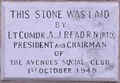 view gallery view gallerySW2.9 km |  1949 - The Avenues Social Club - Dagenham Road, Romford, London, UK 1949 - The Avenues Social Club - Dagenham Road, Romford, London, UK
in Dated Buildings and Cornerstones This 1949 building is on the east side of Dagenham Road in Romford. posted by: Master Mariner location: London, United Kingdom date approved: 09/08/2013 last visited: never |
 view gallery view gallery S3.5 km S3.5 km
| Hornchurch Underground Station - Station Lane, Hornchurch, London, UK in Wikipedia Entries Hornchurch tube station serves the District Line. It is located on the south west side of Station Lane in east London. The entrance and ticket hall straddle the tracks with stairs leading down to the platforms. posted by: Master Mariner location: London, United Kingdom date approved: 07/20/2014 last visited: never |
 view gallery view galleryS3.5 km |  Hornchurch Underground Station - Station Lane, Hornchurch, London, UK Hornchurch Underground Station - Station Lane, Hornchurch, London, UK
in The Underground Hornchurch tube station serves the District Line. It is located on the south west side of Station Lane in east London. The entrance and ticket hall straddle the tracks with stairs leading down to the platforms. posted by: Master Mariner location: London, United Kingdom date approved: 07/24/2014 last visited: never |
 view gallery view galleryS3.5 km |  Cut Bench Mark - Station Lane, Hornchurch, London, UK Cut Bench Mark - Station Lane, Hornchurch, London, UK
in European Historic Survey Stones, Monuments and Benchmarks The mark is cut into the brickwork on the front of Hornchurch railway station situated on the north west side of Station Lane. posted by: Master Mariner location: London, United Kingdom date approved: 09/01/2014 last visited: never |
|