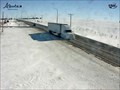
 view gallery view gallery W21.1 km W21.1 km
|   Youngstown Highway Web Camera - Youngstown, Alberta Youngstown Highway Web Camera - Youngstown, Alberta
in Web Cameras This Alberta Highways Webcam is mounted on a steel tower along Highway 9 just west of Youngstown. posted by:  T0SHEA T0SHEA location: Alberta, Canada date approved: 03/03/2014 last visited: 07/28/2014 |
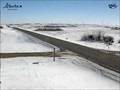 view gallery view gallery SE26.4 km SE26.4 km
| Oyen Highway Web Camera - Oyen, Alberta in Web Cameras This Alberta Highways Webcam is mounted on a steel tower along Highway 9 about midway between Cereal and Oyen. posted by: T0SHEA location: Alberta, Canada date approved: 03/03/2014 last visited: 07/28/2014 |
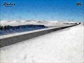 view gallery view gallerySE47.6 km | Sibbald Highway Web Camera - Sibbald, Alberta in Web Cameras This Alberta Highways Webcam is mounted on a steel tower along Highway 9 about midway between Oyen and Sibbald. posted by: T0SHEA location: Alberta, Canada date approved: 03/03/2014 last visited: 08/04/2014 |
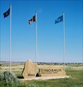
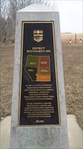 view gallery view gallery NW56.2 km NW56.2 km
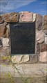
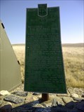
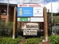
|  District of Boundaries District of Boundaries
in Alberta Heritage Markers Located 15 kilometers south of Coronation Alberta. posted by:  Altima Voyageur Altima Voyageur location: Alberta, Canada date approved: 05/04/2017 last visited: never |
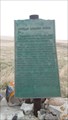
 view gallery view gallery N65.8 km N65.8 km
| The Neutral Hills in Alberta Heritage Markers This cairn is 34 kilometers south of Czar on north side of Buffalo Trail (Hwy 41). Look for Historic signs. posted by: Altima Voyageur location: Alberta, Canada date approved: 09/09/2017 last visited: never |
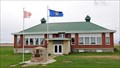
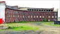 view gallery view galleryW70.5 km |  Canadian Northern Railway Roundhouse - Hanna, AB Canadian Northern Railway Roundhouse - Hanna, AB
in Western Canadian Heritage Canadian Northern Railway, later to become part of the Canadian National Railway, built this roundhouse in Hanna, Alberta in 1913 when Hanna was made a divisional point for the railroad. posted by: T0SHEA location: Alberta, Canada date approved: 03/28/2023 last visited: never |
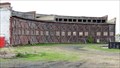 view gallery view galleryW70.5 km |  CNR Roundhouse - Hanna, AB CNR Roundhouse - Hanna, AB
in Railway Roundhouses Canadian Northern Railway, later to become part of the Canadian National Railway, built this roundhouse in Hanna, Alberta in 1913 as Hanna was made a divisional point for the railroad. posted by: T0SHEA location: Alberta, Canada date approved: 07/24/2014 last visited: never |
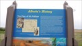 view gallery view galleryW87.7 km | The Plan of Mr. Palliser - Hanna, AB in Alberta Heritage Markers On Highway 9, 17 km. west of Hanna is a pullout for one of the dozens of Alberta Heritage Markers strewn along the highways and byways of the province. posted by: T0SHEA location: Alberta, Canada date approved: 07/06/2014 last visited: never |
 view gallery view gallerySE88.4 km |  Battleford/Red Deer Forks Trail Battleford/Red Deer Forks Trail
in Saskatchewan Historical Markers One of many trails that cross the prairies. The Battleford-Red Deer Forks Trail lies near. posted by: Altima Voyageur location: Saskatchewan, Canada date approved: 05/08/2012 last visited: never |
 view gallery view gallery E90.4 km E90.4 km
| Buffalo Rubbing Stone (Near Flaxcombe) in Saskatchewan Historical Markers Located near the town Flaxcombe on Hwy 7. posted by: Altima Voyageur location: Saskatchewan, Canada date approved: 05/27/2017 last visited: never |
 view gallery view galleryW92.4 km |  Craigmyle Village World War I Memorial - Craigmyle, AB Craigmyle Village World War I Memorial - Craigmyle, AB
in World War I Memorials and Monuments In front of the old Craigmyle School is a stone cairn which was erected in 1927, bearing two plaques - a World War I Memorial Plaque and a World War II Memorial Plaque. posted by: T0SHEA location: Alberta, Canada date approved: 07/30/2014 last visited: never |
 view gallery view galleryW92.4 km |  Craigmyle Village World War II Memorial - Craigmyle, AB Craigmyle Village World War II Memorial - Craigmyle, AB
in World War II Memorials / Monuments In front of the old Craigmyle School is a stone cairn which was erected in 1927, bearing two plaques - a World War I Memorial Plaque and a World War II Memorial Plaque. posted by: T0SHEA location: Alberta, Canada date approved: 07/28/2014 last visited: never |
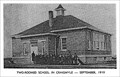 view gallery view galleryW92.4 km |  Craigmyle School - Craigmyle, AB Craigmyle School - Craigmyle, AB
in Former Schools Built in 1919, the Craigmyle School has been repurposed as a civic centre. In front of the old Craigmyle School is a stone cairn which was erected in 1927 as a World War I Memorial. posted by: T0SHEA location: British Columbia, Canada date approved: 02/26/2015 last visited: never |
 view gallery view galleryW93.8 km | Craigmyle Highway Web Camera - Craigmyle, Alberta in Web Cameras This Alberta Highways Webcam is mounted on a steel tower along Highway 9 at Range Road 170. posted by: T0SHEA location: Alberta, Canada date approved: 03/03/2014 last visited: 07/27/2014 |
 view gallery view gallery SW100.7 km SW100.7 km
|  Dinosaur Provincial Park - Alberta, Canada Dinosaur Provincial Park - Alberta, Canada
in State/Provincial Parks Southeastern Alberta, about 200 kilometres more or less straight east of Calgary is where one will find this Provincial Park and World Heritage Site, in the badlands of the Red Deer River. posted by: T0SHEA location: Alberta, Canada date approved: 01/02/2014 last visited: 07/15/2019 |
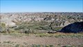 view gallery view gallerySW100.7 km |  Dinosaur Provincial Park - Alberta, Canada Dinosaur Provincial Park - Alberta, Canada
in Paleontology and Fossils Southeastern Alberta, about 200 kilometres more or less straight east of Calgary is where one will find this World Heritage Site, in the badlands of the Red Deer River. posted by: T0SHEA location: Alberta, Canada date approved: 01/04/2014 last visited: 07/13/2019 |
 view gallery view gallerySW100.7 km |  Dinosaur Provincial Park - Alberta, Canada Dinosaur Provincial Park - Alberta, Canada
in Places of Geologic Significance Southeastern Alberta, about 200 kilometres more or less straight east of Calgary is where one will find this World Heritage Site, in the badlands of the Red Deer River. posted by: T0SHEA location: Alberta, Canada date approved: 01/04/2014 last visited: 07/13/2019 |
 view gallery view gallerySW100.7 km |  Dinosaur Provincial Park - Brooks, Alberta Dinosaur Provincial Park - Brooks, Alberta
in Official Local Tourism Attractions Southeastern Alberta, about 200 kilometres more or less straight east of Calgary is where one will find this Provincial Park and World Heritage Site, in the badlands of the Red Deer River. posted by: T0SHEA location: Alberta, Canada date approved: 01/04/2014 last visited: 07/15/2019 |
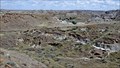 view gallery view gallerySW100.7 km |  Dinosaur Provincial Park - Alberta, Canada Dinosaur Provincial Park - Alberta, Canada
in World Heritage Sites Southeastern Alberta, about 200 kilometres more or less straight east of Calgary is where one will find this World Heritage Site, in the badlands of the Red Deer River. posted by: T0SHEA location: Alberta, Canada date approved: 01/01/2014 last visited: 07/13/2019 |
 view gallery view gallerySW100.7 km |  Dinosaur Provincial Park - Alberta, Canada Dinosaur Provincial Park - Alberta, Canada
in Wikipedia Entries Southeastern Alberta, about 200 kilometres more or less straight east of Calgary is where one will find this World Heritage Site, in the badlands of the Red Deer River. posted by: T0SHEA location: Alberta, Canada date approved: 01/02/2014 last visited: 07/13/2019 |
 view gallery view galleryNW101.2 km |  Tourism Discovery Centre - Williams Lake, British Columbia Tourism Discovery Centre - Williams Lake, British Columbia
in Tourist Information Centers - Visitor Centers Tourism Discovery Centre includes the visitor centre and is located at 1660 Broadway Avenue S. posted by: T0SHEA location: British Columbia, Canada date approved: 08/27/2019 last visited: never |
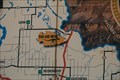 view gallery view gallerySW102.8 km |  You Are Here - Newell County, Alberta You Are Here - Newell County, Alberta
in 'You Are Here' Maps This sign confirms you aren't the only one to tour this long stretch of very quiet highway in rural eastern Alberta. posted by: Trail Blaisers location: Alberta, Canada date approved: 04/23/2019 last visited: never |
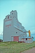 view gallery view galleryE105.6 km |  Saskatchewan Wheat Pool B - Laporte, Saskatchewan Saskatchewan Wheat Pool B - Laporte, Saskatchewan
in Grain Elevators Along Highway 44, the tiny hamlet of Laporte is 39 short km. east of the Alberta border. posted by: T0SHEA location: Saskatchewan, Canada date approved: 02/07/2013 last visited: 02/22/2014 |
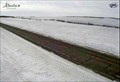 view gallery view galleryNW105.9 km | Highway 36 & TWP Road 392 South Highway Webcam - Alliance, AB in Web Cameras This Alberta Highways Webcam is mounted on a steel tower on the east side of Highway 16 south of the town of Alliance. posted by: T0SHEA location: Alberta, Canada date approved: 03/05/2014 last visited: 08/03/2014 |
 view gallery view galleryNW105.9 km | Highway 36 & TWP Road 392 Road Highway Webcam - Alliance, AB in Web Cameras This Alberta Highways Webcam is mounted on a steel tower on the east side of Highway 16 south of the town of Alliance. posted by: T0SHEA location: Alberta, Canada date approved: 03/05/2014 last visited: 08/03/2014 |
|