 view gallery view gallery W0.5 km W0.5 km
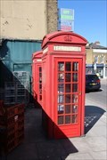
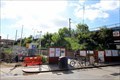
|   Red Telephone Boxes - Homerton High Street, London, UK Red Telephone Boxes - Homerton High Street, London, UK
in Red Telephone Boxes This pair of K2 telephone boxes are located on the south side of Homerton High Street in east London. posted by:  Master Mariner Master Mariner location: London, United Kingdom date approved: 08/16/2018 last visited: never |
 view gallery view gallery S0.6 km S0.6 km
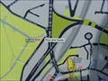
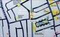
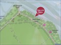
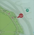
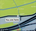
|  You Are Here - Wick Road, London, UK You Are Here - Wick Road, London, UK
in 'You Are Here' Maps This "you are here" map is on the south side of Wick Road at the junction with Cadogan Terrace. It is outside the Molesworth Gate entrance to Victoria Park. posted by: Master Mariner location: London, United Kingdom date approved: 08/18/2015 last visited: never |
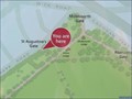
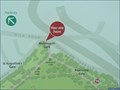 view gallery view galleryS0.6 km | You Are Here - Victoria Park, London, UK in 'You Are Here' Maps The park entrance where this map is located is called "Molesworth Gate". It is located at the north corner of the east part of Victoria Park and gives access to the park from Wick Road. posted by: Master Mariner location: London, United Kingdom date approved: 08/17/2015 last visited: never |
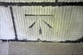
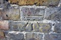
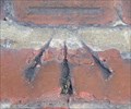 view gallery view galleryS0.6 km |  Cut Bench Mark - Victoria Park, London, UK Cut Bench Mark - Victoria Park, London, UK
in U.K. and Ireland Trigpoints This mark is cut into the brickwork of a building in Victoria Park. The building is close to the Molesworth Gate entrance to the park and is behind wire fencing but can be seen from the road/path in the park. posted by: Master Mariner location: London, United Kingdom date approved: 08/15/2015 last visited: never |
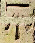
 view gallery view galleryW0.6 km | Cut Bench Mark - St Barnabas Church, Homerton, London, UK in U.K. and Ireland Trigpoints The mark is cut into the stonework of the tower of St Barnabas Church on the north side of Homerton High Street. The mark is cut into the south face of the tower at its mid-length. posted by: Master Mariner location: London, United Kingdom date approved: 05/23/2018 last visited: never |
 view gallery view galleryS0.6 km | Cut Bench Mark - Victoria Park, London, UK in U.K. and Ireland Trigpoints The mark is cut into the brickwork of a building in Victoria Park. The building that is/was known as Molesworth Lodge is close to the Molesworth Gate entrance to Victoria Park. posted by: Master Mariner location: London, United Kingdom date approved: 08/15/2015 last visited: never |
 view gallery view gallery SW0.6 km SW0.6 km
| You Are Here - Barnabas Road, London, UK in 'You Are Here' Maps This "you are here" map is located close to Homerton Overground station. The map is at the junction of Barnabas Road and Berger Road almost beneath the railway bridge to the east of the station. posted by: Master Mariner location: London, United Kingdom date approved: 08/16/2018 last visited: never |
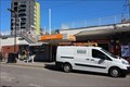 view gallery view gallerySW0.6 km |  Homerton Railway Station - Berger Road, London, UK Homerton Railway Station - Berger Road, London, UK
in Wikipedia Entries Homerton railway station serves the London Overground system The station entrance, in Berger Road, is at street level with the platforms and tracks being above the entrance. The tracks travel in an east/west direction at the station. posted by: Master Mariner location: London, United Kingdom date approved: 08/15/2018 last visited: never |
 view gallery view gallerySW0.6 km |  Homerton Railway Station - Berger Road, London, UK Homerton Railway Station - Berger Road, London, UK
in Train Stations/Depots Homerton railway station serves the London Overground system The station entrance, in Berger Road, is at street level with the platforms and tracks being above the entrance. The tracks travel in an east/west direction at the station. posted by: Master Mariner location: London, United Kingdom date approved: 08/15/2018 last visited: 03/18/2023 |
 view gallery view galleryS0.6 km | You Are Here - Victoria Park, London, UK in 'You Are Here' Maps The park entrance where this map is located is called "Riseholme Gate". It is located on the north east side of the east part of Victoria Park and gives access to the park from Cadogan Terrace. posted by: Master Mariner location: London, United Kingdom date approved: 08/17/2015 last visited: never |
 view gallery view galleryS0.6 km | You Are Here - Victoria Park, London, UK in 'You Are Here' Maps The park entrance where this map is located is called "St Augustine's Gate". It is located on the north west side of the east part of Victoria Park and gives access to the park from Victoria Park Road. posted by: Master Mariner location: London, United Kingdom date approved: 08/17/2015 last visited: never |
 view gallery view galleryW0.8 km | Cut Bench Mark - Digby Road, Homerton, London, UK in U.K. and Ireland Trigpoints This mark is cut into the brickwork parapet of s railway bridge that straddles Digby Road in Homerton. The mark is on the west side of Digby Road at the north side of the bridge. posted by: Master Mariner location: London, United Kingdom date approved: 05/23/2018 last visited: never |
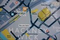 view gallery view gallery SE0.8 km SE0.8 km
| You Are Here - Wallis Road, London, UK in 'You Are Here' Maps This "you are here" map is located on the east side of Wallis Road at the junction with Berkshire Road in Hackney Wick, London. posted by: Master Mariner location: London, United Kingdom date approved: 08/18/2018 last visited: never |
 view gallery view galleryS0.8 km | Cut Bench Mark - Victoria Park, London, UK in U.K. and Ireland Trigpoints Within the Cadogan Gate entrance to Victoria Park there are two alcove shelters taken from the old London Bridge. This mark is cut into the stonework of the northern one and is on the south west face. posted by: Master Mariner location: London, United Kingdom date approved: 08/16/2015 last visited: 02/03/2021 |
 view gallery view galleryS0.8 km |  Cut Bench Mark - Victoria Park, London, UK Cut Bench Mark - Victoria Park, London, UK
in European Historic Survey Stones, Monuments and Benchmarks Within the Cadogan Gate entrance to Victoria Park there are two alcove shelters taken from the old London Bridge. This mark is cut into the stonework of the northern one and is on the south west face. posted by: Master Mariner location: London, United Kingdom date approved: 08/17/2015 last visited: never |
 view gallery view galleryS1 km | You Are Here - Victoria Park, London, UK in 'You Are Here' Maps The park entrance where this map is located is called "Cadogan Gate". It is located on the north east side of the east part of Victoria Park and gives access to the park from Cadogan Terrace. posted by: Master Mariner location: London, United Kingdom date approved: 08/17/2015 last visited: never |
 view gallery view gallery E1 km E1 km
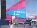
|  Riverbank Arena - Stratford, London, UK Riverbank Arena - Stratford, London, UK
in Satellite Imagery Oddities The Hockey events at the London 2012 Olympic Games were held at the Riverside Arena towards the northern end of the Olympic Park. After the games the arena was dismantled and moved to Eton Manor which is about 500 metres to the north east. posted by: Master Mariner location: London, United Kingdom date approved: 01/04/2016 last visited: never |
 view gallery view galleryE1 km | Riverbank Arena - Stratford, London, UK in Wikipedia Entries The Riverbank Arena is towards the northern end of the Stratford Olympic Park and is on the west side of the River Lea (Lee). This is the venue for hockey. posted by: Master Mariner location: London, United Kingdom date approved: 10/18/2012 last visited: 09/01/2012 |
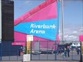 view gallery view galleryE1 km |  Riverbank Arena - London 2012 - Stratford, London, UK Riverbank Arena - London 2012 - Stratford, London, UK
in Modern Olympic Venues The Riverbank Arena is towards the northern end of the Stratford Olympic Park and is on the west side of the River Lea (Lee). This is the venue for hockey. posted by: Master Mariner location: London, United Kingdom date approved: 07/31/2012 last visited: 09/09/2012 |
 view gallery view galleryE1 km |  Hockey Centre - OLYMPIC GAMES EDITION - Stratford, London, UK Hockey Centre - OLYMPIC GAMES EDITION - Stratford, London, UK
in Monopoly in the Real World The Hockey events at the London 2012 Olympic Games were held at the Riverside Arena towards the northern end of the Olympic Park. After the games the arena was dismantled and moved to Eton Manor which is about 500 metres to the north east. posted by: Master Mariner location: London, United Kingdom date approved: 01/04/2016 last visited: never |
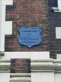 view gallery view galleryS1 km |  Poplar Borough Boundary Marker - Cadogan Terrace, London, UK Poplar Borough Boundary Marker - Cadogan Terrace, London, UK
in Public Land Survey Marks A London Borough boundary marker in the form of a metal plaque set into the wall of a former public house, marking the boundary between the Boroughs of Poplar and Hackney. posted by:  OrientGeo OrientGeo location: London, United Kingdom date approved: 02/06/2021 last visited: 02/13/2021 |
 view gallery view gallerySE1 km | Hackney Wick Railway Station - Wallis Road, London, UK in Wikipedia Entries Hackney Wick railway station services the London Overground rail service. The platforms and tracks are above ground and are accesible, both north and south of the tracks, by long sloping ramps. A prestrian footbridge connects the platforms. posted by: Master Mariner location: London, United Kingdom date approved: 08/18/2018 last visited: 05/17/2021 |
 view gallery view gallerySE1 km | Hackney Wick Railway Station - Wallis Road, London, UK in Train Stations/Depots Hackney Wick railway station services the London Overground rail service. The platforms and tracks are above ground and are accesible, both north and south of the tracks, by long sloping ramps. A pedestrian footbridge connects the platforms. posted by: Master Mariner location: London, United Kingdom date approved: 08/18/2018 last visited: 04/27/2021 |
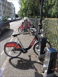 view gallery view galleryS1 km |  Victoria Park - Cadogan Close, London UK Victoria Park - Cadogan Close, London UK
in Bicycle Rentals A docking station for Santander Cycles (new sponsors from February 2015). This docking station is on the south side of south west side of Cadogan Terrace opposite Cadogan Close from where the docking station gets its name. posted by: Master Mariner location: London, United Kingdom date approved: 08/16/2015 last visited: never |
 view gallery view galleryS1 km | You Are Here - Cadogan Terrace, London, UK in 'You Are Here' Maps This "you are here" map is at a docking station for Santander Cycles (new sponsors from February 2015). This docking station is on the south west side of Cadogan Terrace opposite Cadogan Close from where the docking station gets its name. posted by: Master Mariner location: London, United Kingdom date approved: 08/16/2015 last visited: never |
|