 view gallery view gallery NE1.8 km NE1.8 km
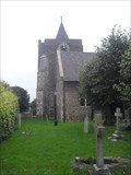
|   Church of St.Margaret of Antioch, The Green, Stanford-le-Hope, Essex, SS17 0BY Church of St.Margaret of Antioch, The Green, Stanford-le-Hope, Essex, SS17 0BY
in This Old Church Mainly of C12th build, there have been additions right up to the building of the tower in 1883. posted by:  greysman greysman location: Eastern England, United Kingdom date approved: 10/18/2017 last visited: never |
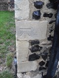
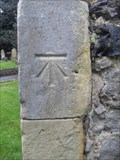 view gallery view galleryNE1.8 km |  Cut Bench Mark - Church of St.Margaret of Antioch, Stanford-le-Hope, The Green, Stanford-le-Hope, Essex, SS17 0BY Cut Bench Mark - Church of St.Margaret of Antioch, Stanford-le-Hope, The Green, Stanford-le-Hope, Essex, SS17 0BY
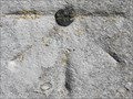
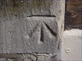
in U.K. and Ireland Trigpoints An almost pristine cut mark on the east face at the south-east angle of the old church. posted by: greysman location: Eastern England, United Kingdom date approved: 10/17/2017 last visited: never |
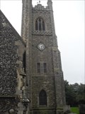 view gallery view galleryNE1.8 km |  Bell Tower - Church of St.Margaret of Antioch, The Green, Stanford-le-Hope, Essex, SS17 0BY Bell Tower - Church of St.Margaret of Antioch, The Green, Stanford-le-Hope, Essex, SS17 0BY
in Bell Towers An 1883 rebuild of a collapsed tower. posted by: greysman location: Eastern England, United Kingdom date approved: 10/17/2017 last visited: never |
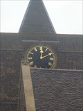
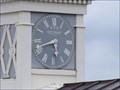
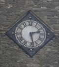 view gallery view galleryNE1.8 km |  Church Clock - Church of St.Margaret of Antioch, The Green, Stanford-le-Hope, Essex, SS17 0BY Church Clock - Church of St.Margaret of Antioch, The Green, Stanford-le-Hope, Essex, SS17 0BY
in Town Clocks There are three clock faces on the Victorian tower of this old church. posted by: greysman location: Eastern England, United Kingdom date approved: 10/18/2017 last visited: never |
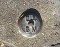
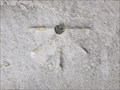
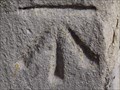
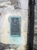 view gallery view galleryNE1.8 km | Flush Bracket - Church of St.Margaret of Antioch, Stanford-le-Hope, The Green, Stanford-le-Hope, Essex, SS17 0BY in U.K. and Ireland Trigpoints This slightly worn flush bracket is on the north face of the chancel of this old church. posted by: greysman location: Eastern England, United Kingdom date approved: 10/17/2017 last visited: never |
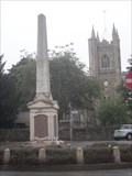
 view gallery view galleryNE1.8 km |  Combined War Memorial, The Green, Stanford-le-hope, Essex. SS17 0EX Combined War Memorial, The Green, Stanford-le-hope, Essex. SS17 0EX
in World War I Memorials and Monuments A combined war memorial on 'The Green' in Stanford-le-Hope. posted by: greysman location: Eastern England, United Kingdom date approved: 10/22/2017 last visited: never |
 view gallery view gallery NW3.7 km NW3.7 km
| St.Giles and All Saints' Church, High Road, Orsett, Essex. RM16 3ER in This Old Church A old church dating back to the C12th with later additions. posted by: greysman location: Eastern England, United Kingdom date approved: 10/14/2017 last visited: never |
 view gallery view galleryNW3.7 km | Church of St.Giles and All Saints, High Road, Orsett, Essex. RM16 3ER in U.K. and Ireland Trigpoints A neat cut mark on the south face of the south aisle, west end. posted by: greysman location: Eastern England, United Kingdom date approved: 10/17/2017 last visited: never |
 view gallery view galleryNW3.7 km | Church Clock - Church of St.Giles and All Saints, High Road, Orsett, Essex. RM16 3ER in Town Clocks Church clock on the south face of the church tower. posted by: greysman location: Eastern England, United Kingdom date approved: 10/16/2017 last visited: never |
 view gallery view galleryNW3.7 km | Bell Tower - St.Giles and All Saints' Church, High Road, Orsett, Essex. RM16 3ER in Bell Towers This old church dating back to the C12th now has a ring of six bells in the tower. posted by: greysman location: Eastern England, United Kingdom date approved: 10/17/2017 last visited: never |
 view gallery view gallery N6.1 km N6.1 km
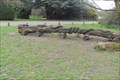
|  Dinner - Westley Heights, Langdon Hills Country Park, Basildon, Essex Dinner - Westley Heights, Langdon Hills Country Park, Basildon, Essex
in Outside Wooden Display Carvings Eyeing you -- eyeing me. posted by: greysman location: Eastern England, United Kingdom date approved: 04/14/2012 last visited: never |
 view gallery view gallery SW6.1 km SW6.1 km
| EABM - Tilbury Fort in U.K. and Ireland Trigpoints Environment Agency Benchmark at Tilbury Fort, Essex. posted by: vw_k location: South East England, United Kingdom date approved: 03/02/2010 last visited: never |
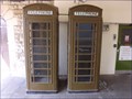 view gallery view gallerySW6.8 km |  Army Drab Telephone Boxes - Royal Terrace Pier, Royal Pier Road, Gravesend, Kent, UK Army Drab Telephone Boxes - Royal Terrace Pier, Royal Pier Road, Gravesend, Kent, UK
in Red Telephone Boxes This pair of "red" telephone boxes are at the landward end of the Royal Terrace Pier in Gravesend. posted by:  Master Mariner Master Mariner location: South East England, United Kingdom date approved: 05/05/2013 last visited: never |
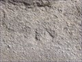 view gallery view gallerySW6.8 km | Cut Bench Mark - Royal Pier Road, Gravesend, Kent, UK in U.K. and Ireland Trigpoints This mark is cut into the wall at the southern end of the Royal Terrace Pier on the north side of Royal Pier Road in Gravesend. posted by: Master Mariner location: South East England, United Kingdom date approved: 05/05/2013 last visited: never |
 view gallery view gallerySW6.8 km |  Cut Bench Mark - Royal Pier Road, Gravesend, Kent, UK Cut Bench Mark - Royal Pier Road, Gravesend, Kent, UK
in European Historic Survey Stones, Monuments and Benchmarks This mark is cut into the wall at the southern end of the Royal Terrace Pier on the north side of Royal Pier Road in Gravesend. posted by: Master Mariner location: South East England, United Kingdom date approved: 05/05/2013 last visited: never |
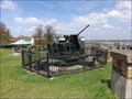 view gallery view gallerySW6.9 km |  Bofors L.70 - New Tavern Fort, Gravesend, Kent, UK Bofors L.70 - New Tavern Fort, Gravesend, Kent, UK
in Static Artillery Displays This artillery piece is in New Tavern Fort Gardens on top of some of the bunkers. The area around this gun is free to access as are all areas outside the bunkers. posted by: Master Mariner location: United Kingdom date approved: 05/19/2013 last visited: never |
 view gallery view gallerySW6.9 km | Cut Bench Mark & Bolt - The Terrace, Gravesend, Kent, UK in U.K. and Ireland Trigpoints This mark is cut into the south east corner of the Custom House building on the north side of The Terrace in Gravesend. posted by: Master Mariner location: South East England, United Kingdom date approved: 05/06/2013 last visited: never |
 view gallery view gallerySW6.9 km | Cut Bench Mark & Bolt - The Terrace, Gravesend, Kent, UK in European Historic Survey Stones, Monuments and Benchmarks This mark is cut into the south east corner of the Custom House building on the north side of The Terrace in Gravesend. posted by: Master Mariner location: South East England, United Kingdom date approved: 05/06/2013 last visited: never |
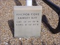 view gallery view gallerySW6.9 km |  51° 26' 30" N & 0° 22' 25" E - Anchor Cove, Bawley Bay, Gravesend, Kent, UK 51° 26' 30" N & 0° 22' 25" E - Anchor Cove, Bawley Bay, Gravesend, Kent, UK
in Permanent Geographic Coordinates This small marker, showing the co-ordinates, is located in a small memorial garden for river workers and merchant seamen. posted by: Master Mariner location: South East England, United Kingdom date approved: 05/13/2013 last visited: never |
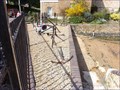 view gallery view gallerySW6.9 km |  Anchor Cove - Royal Pier Road, Gravesend, Kent, UK Anchor Cove - Royal Pier Road, Gravesend, Kent, UK
in Anchors A small collection of anchors collected from various river craft that have plied their trade on the River Thames. posted by: Master Mariner location: South East England, United Kingdom date approved: 05/12/2013 last visited: never |
 view gallery view gallerySW6.9 km | Cut Bench Mark - Royal Pier Road, Gravesend, Kent, UK in U.K. and Ireland Trigpoints This mark is cut into the south face of the St Andrew's Art Centre on the north side of Royal Pier Road in Gravesend. posted by: Master Mariner location: South East England, United Kingdom date approved: 05/05/2013 last visited: never |
 view gallery view gallerySW6.9 km | Cut Bench Mark - Royal Pier Road, Gravesend, Kent, UK in European Historic Survey Stones, Monuments and Benchmarks This mark is cut into the south face of the St Andrew's Art Centre on the north side of Royal Pier Road in Gravesend. posted by: Master Mariner location: South East England, United Kingdom date approved: 05/05/2013 last visited: never |
 view gallery view gallerySW6.9 km | Gravesend Town Pier Clock - West Street, Gravesend, Kent, UK in Town Clocks This lock sits atop the building at the end of the original part of the pier. The co-ordinates are given for the landward end of the pier. posted by: Master Mariner location: South East England, United Kingdom date approved: 05/07/2013 last visited: never |
 view gallery view gallerySW6.9 km |  The Three Daws - West Street, Gravesend, Kent, UK The Three Daws - West Street, Gravesend, Kent, UK
in Pictorial Pub Signs This old pub is on than banks of the River Thames at the foot of the Town Pier. posted by: Master Mariner location: South East England, United Kingdom date approved: 05/09/2013 last visited: 06/24/2021 |
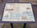 view gallery view gallerySW6.9 km |  Gravesend Ferries - West Street, Garvesend, Kent, UK Gravesend Ferries - West Street, Garvesend, Kent, UK
in UK Historical Markers This information table, close to the Town Pier, explains how the ferries helped the town to thrive. posted by: Master Mariner location: South East England, United Kingdom date approved: 05/07/2013 last visited: never |
|