 view gallery view gallery W1.8 km W1.8 km
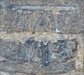
|   Cut Bench Mark - Clifford Road, South Norwood, London, UK Cut Bench Mark - Clifford Road, South Norwood, London, UK
in U.K. and Ireland Trigpoints This mark is cut into brickwork on the west side of Clifford Road. The building is a part of Norwood Junction railway station with the being just to the north of the entry of a subway that leads under the tracks to the other side of the station. posted by:  Master Mariner Master Mariner location: London, United Kingdom date approved: 07/25/2014 last visited: never |
 view gallery view galleryW1.8 km |  Cut Bench Mark - Clifford Road, South Norwood, London, UK Cut Bench Mark - Clifford Road, South Norwood, London, UK
in European Historic Survey Stones, Monuments and Benchmarks This mark is cut into brickwork on the west side of Clifford Road. The building is a part of Norwood Junction railway station with the being just to the north of the entry of a subway that leads under the tracks to the other side of the station. posted by: Master Mariner location: London, United Kingdom date approved: 07/25/2014 last visited: never |
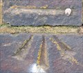 view gallery view gallery NW1.8 km NW1.8 km
| Cut Bench Mark - Anerley Road, London, UK in U.K. and Ireland Trigpoints This mark is cut into the brickwork of a bridge paprapet on the south west side of Anerley Road. The mark is towards the north west end of the bridge. posted by: Master Mariner location: London, United Kingdom date approved: 12/06/2015 last visited: 12/26/2020 |
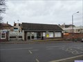 view gallery view galleryNW1.8 km |  Anerley Overground and Mainline Station - Anerley Station Road, London, UK Anerley Overground and Mainline Station - Anerley Station Road, London, UK
in Train Stations/Depots Anerley railway station is located on the north west side of Anerley Station Road. The station serves London Overground and Southern rail services. The station has two platforms connected by a pedestrian footbridge. posted by: Master Mariner location: London, United Kingdom date approved: 12/05/2015 last visited: 12/26/2020 |
 view gallery view galleryNW1.8 km |  Anerley Railway Station - Anerley Station Road, London, UK Anerley Railway Station - Anerley Station Road, London, UK
in Wikipedia Entries Anerley railway station is located on the north west side of Anerley Station Road. The station serves London Overground and Southern rail services. The station has two platforms connected by a pedestrian footbridge. posted by: Master Mariner location: London, United Kingdom date approved: 12/05/2015 last visited: never |
 view gallery view galleryW1.8 km |  Stanley Tech, South Norwood Hill Stanley Tech, South Norwood Hill
in Immortalized in Lyrics Captain Sensible sings that he attended Stanley Tech in his song "Croydon" posted by: Team Sieni location: London, United Kingdom date approved: 06/22/2021 last visited: 07/27/2021 |
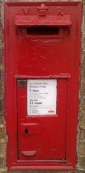 view gallery view galleryW1.8 km |  Norwood Junction Station Post Box, Norwood, London SE25. UK Norwood Junction Station Post Box, Norwood, London SE25. UK
in Victorian Post Boxes Norwood Junction Station set in station building wall. posted by:  AngelPick AngelPick location: London, United Kingdom date approved: 05/18/2011 last visited: 12/26/2020 |
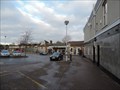
 view gallery view galleryW1.8 km | Norwood Junction Station - Station Road, South Norwood, London, UK in Train Stations/Depots Norwood Junction station serves both mainline services and London Overground. The station can be accessed from the north west side (Station Road) and south east side (Clifford Road) of the tracks. posted by: Master Mariner location: London, United Kingdom date approved: 07/28/2014 last visited: 12/26/2020 |
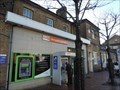 view gallery view galleryW1.8 km | Norwood Junction Station - Station Road, South Norwood, London, UK in Wikipedia Entries Norwood Junction station serves both mainline services and London Overground. The station can be accessed from the north west side (Station Road) and south east side (Clifford Road) of the tracks. posted by: Master Mariner location: London, United Kingdom date approved: 07/25/2014 last visited: never |
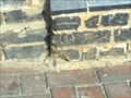 view gallery view galleryW1.8 km | Cut Bench Mark, Norwood Junction Station, London UK in U.K. and Ireland Trigpoints A Cut Bench Mark on the railway station building. posted by: AngelPick location: London, United Kingdom date approved: 08/27/2011 last visited: 12/26/2020 |
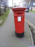 view gallery view galleryNW1.8 km | Victorian Post Box - Oakfield Road, London, UK in Victorian Post Boxes This Victorian post box is located on the south east side of Oakfield Road at the junction with Woodbine Grove in Penge in south London. posted by: Master Mariner location: London, United Kingdom date approved: 12/06/2015 last visited: never |
 view gallery view gallery NE1.9 km NE1.9 km
| Cut Bench Mark - Copers Cope Road, New Beckenham, London, UK in U.K. and Ireland Trigpoints This mark is cut into a brick built post at the corner of two fences on the south east corner of the junction between Copers Cope Road and Lawn Road. posted by: Master Mariner location: London, United Kingdom date approved: 07/25/2014 last visited: never |
 view gallery view galleryNE1.9 km | Cut Bench Mark - Copers Cope Road, New Beckenham, London, UK in European Historic Survey Stones, Monuments and Benchmarks This mark is cut into a brick built post at the corner of two fences on the south east corner of the junction between Copers Cope Road and Lawn Road. posted by: Master Mariner location: London, United Kingdom date approved: 07/25/2014 last visited: never |
 view gallery view galleryNE1.9 km |  Beckenham High St. Milestone, Beckenham, London Beckenham High St. Milestone, Beckenham, London
in Milestones A milestone in Beckenham, placed in 1713, with directions to London Bridge, Bromley and Croydon markets, Shortlands and the Swan in Wickham. posted by: Team Sieni location: United Kingdom date approved: 01/20/2008 last visited: 08/03/2021 |
 view gallery view galleryNE1.9 km | Flush Bracket - Bromley Road, Beckenham, London, UK in U.K. and Ireland Trigpoints This flush bracket (S0532) is attached to the northern most corner of Beckenham Public Hall that is located on the south west side of Bromley Road opposite St George's church. posted by: Master Mariner location: London, United Kingdom date approved: 07/24/2014 last visited: 08/03/2021 |
 view gallery view galleryNE1.9 km | Flush Bracket - Bromley Road, Beckenham, London, UK in European Historic Survey Stones, Monuments and Benchmarks This flush bracket (S0532) is attached to the northern most corner of Beckenham Public Hall that is located on the south west side of Bromley Road opposite St George's church. posted by: Master Mariner location: London, United Kingdom date approved: 07/25/2014 last visited: never |
 view gallery view galleryNE1.9 km | Cut Bench Mark - High Street, Beckenham, London, UK in U.K. and Ireland Trigpoints This mark is cut into a buttress on St George's church that is located on the east side of the High Street in Beckenham. posted by: Master Mariner location: London, United Kingdom date approved: 07/24/2014 last visited: 08/03/2021 |
 view gallery view galleryNE1.9 km | Cut Bench Mark - High Street, Beckenham, London, UK in European Historic Survey Stones, Monuments and Benchmarks This mark is cut into a buttress on St George's church that is located on the east side of the High Street in Beckenham. posted by: Master Mariner location: London, United Kingdom date approved: 07/25/2014 last visited: never |
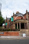
 view gallery view galleryNE2.1 km | Beckenham Junction Station - Station Approach, Beckenham, London, UK in Train Stations/Depots The station is on the north side of Station Approach. A few steps to the south west of the entrance is a tram terminus, limited car parking and bus standing. posted by: Master Mariner location: London, United Kingdom date approved: 07/28/2014 last visited: 08/03/2021 |
 view gallery view galleryNE2.1 km | Beckenham Junction Station - Station Approach, Beckenham, London, UK in Wikipedia Entries The station is on the north side of Station Approach. A few steps to the south west of the entrance is a tram terminus, limited car parking and bus standing. posted by: Master Mariner location: London, United Kingdom date approved: 07/25/2014 last visited: never |
 view gallery view galleryNE2.1 km | Pillar box, New Beckenham, London in Victorian Post Boxes A. Handyside manufactured pillar box near New Beckenham station. posted by: Team Sieni location: London, United Kingdom date approved: 01/20/2012 last visited: 02/01/2014 |
 view gallery view gallery N2.1 km N2.1 km
| Penge West Overground and Mainline Station - Anerley Park, London, UK in Train Stations/Depots Penge West station stands at the end of a short cul-de-sac on the south east side of Anerley Park. The station handles services operated by London Overground and Southern. The station has two platforms connected by a pedestrian footbridge. posted by: Master Mariner location: London, United Kingdom date approved: 12/05/2015 last visited: never |
 view gallery view galleryN2.1 km | Penge West Railway Station - Anerley Park, London, UK in Wikipedia Entries Penge West station stands at the end of a short cul-de-sac on the south east side of Anerley Park. The station handles services operated by London Overground and Southern. The station has two platforms connected by a pedestrian footbridge. posted by: Master Mariner location: London, United Kingdom date approved: 12/05/2015 last visited: never |
 view gallery view galleryNE2.1 km | Victorian Post Box - Park Road, London, UK in Victorian Post Boxes This Victorian wall box is located on the north side of Park Road in Beckenham, London. The box is set into the end of a wall that divides two gardens. posted by: Master Mariner location: London, United Kingdom date approved: 06/17/2022 last visited: never |
 view gallery view galleryNE2.3 km | Cut Bench Mark - Brackley Road, New Beckenham, London, UK in U.K. and Ireland Trigpoints This mark is cut into stone at the north corner of the church tower. The church is located on the south west side of Brackley Road in a well looked after churchyard. posted by: Master Mariner location: London, United Kingdom date approved: 07/25/2014 last visited: never |
|