 view gallery view gallery S5.1 km S5.1 km
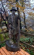
|   Schwarzer Mann, Schneifel, Sellerich, RLP, Germany Schwarzer Mann, Schneifel, Sellerich, RLP, Germany
in Outside Wooden Display Carvings Holzfigur auf einer der höchsten Erhebungen in der Eifel / Wooden figure on one of the highest elevations in the Eifel (698 m). posted by:  Tillba Tillba location: Rheinland-Pfalz, Germany date approved: 09/19/2022 last visited: never |
 view gallery view gallery SE5.3 km SE5.3 km
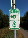
|  UTM 313244 / 5570835, Gondenbrett, Germany UTM 313244 / 5570835, Gondenbrett, Germany
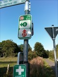
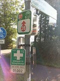
in Permanent Geographic Coordinates Wegweiser im Wandergebiet Schwarzer Mann
Signposts in the Schwarzer Mann hiking area posted by: Tillba location: Rheinland-Pfalz, Germany date approved: 10/19/2022 last visited: never |
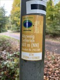 view gallery view gallerySE5.3 km |  Abzweig Sellerich, Gondenbrett, Germany - 601m (NN) Abzweig Sellerich, Gondenbrett, Germany - 601m (NN)
in Elevation Signs Höhenangabe Abzweig Sellerich
Height indication Abzweig Sellerich posted by: Tillba location: Rheinland-Pfalz, Germany date approved: 10/18/2022 last visited: never |
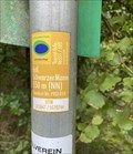
 view gallery view gallerySE5.8 km | Schwarzer Mann, Schneifel/ Wascheid, Germany - 550m (NN) in Elevation Signs Höhenangabe Schwarzer Mann
Height indication Schwarzer Mann posted by: Tillba location: Rheinland-Pfalz, Germany date approved: 10/14/2022 last visited: never |
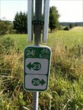
 view gallery view gallerySE5.8 km | UTM 313847/ 5570744, Wascheid, Germany in Permanent Geographic Coordinates Wegweiser im Wandergebiet Schwarzer Mann
Signposts in the Schwarzer Mann hiking area posted by: Tillba location: Rheinland-Pfalz, Germany date approved: 10/14/2022 last visited: never |
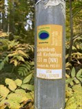 view gallery view gallerySE6.1 km | Gondenbrett: südl. Kirchenberg, Gondenbrett, Germany - 531m (NN) in Elevation Signs Höhenangabe Schwarzer Mann
Height indication Schwarzer Mann posted by: Tillba location: Rheinland-Pfalz, Germany date approved: 10/18/2022 last visited: never |
 view gallery view gallerySE6.1 km | UTM 313656 / 5570228, Gondenbrett, Germany in Permanent Geographic Coordinates Wegweiser im Wandergebiet Schwarzer Mann
Signposts in the Schwarzer Mann hiking area posted by: Tillba location: Rheinland-Pfalz, Germany date approved: 10/19/2022 last visited: never |
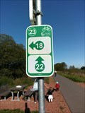
 view gallery view gallery NE6.8 km NE6.8 km
|  28 - Losheim - DE 28 - Losheim - DE
in Cycling Routes Kyllradweg, Knotenpunkt 28, Am Goldenbach, Losheim posted by:  TeamYakara TeamYakara location: Nordrhein-Westfalen, Germany date approved: 10/12/2019 last visited: never |
 view gallery view galleryNE6.9 km |  Siegfried Line- Dragon Teeth, Losheim, Germany Siegfried Line- Dragon Teeth, Losheim, Germany
in World War II Sites The "Siegfried Line", known in German as the Westwall, and to the Allies as the Dragons Teeth, was a German defensive line built during the 1930s opposite the French Maginot Line. posted by: TeamYakara location: Nordrhein-Westfalen, Germany date approved: 10/03/2019 last visited: never |
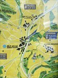
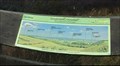
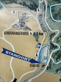 view gallery view gallerySE7.4 km |  Wandern und erholen (Wanderkarte), Wascheid, RLP, Germany Wandern und erholen (Wanderkarte), Wascheid, RLP, Germany
in 'You Are Here' Maps Wanderkarte am Wascheider Stausee
Hiking map at the Wascheider Reservoir posted by: Tillba location: Rheinland-Pfalz, Germany date approved: 10/01/2022 last visited: never |
 view gallery view gallery E7.4 km E7.4 km
|  Bragphenn, Ormont, RLP, Germany Bragphenn, Ormont, RLP, Germany
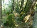
in Hiking and walking trailheads Das Bragphenn ist ein Sattelregen-Hochmoor in der Nähe von Ormont
The Bragphenn is a saddle rain raised bog near Ormont posted by: Tillba location: Rheinland-Pfalz, Germany date approved: 10/04/2022 last visited: never |
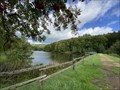 view gallery view gallerySE7.4 km |  Stausee Wascheid, Gondenbrett-Wascheid, RLP, Germany Stausee Wascheid, Gondenbrett-Wascheid, RLP, Germany
in Water Dams Kleiner Stausee am Fuß der Schneifel
Small reservoir at the foot of the Schneifel posted by: Tillba location: Rheinland-Pfalz, Germany date approved: 10/05/2022 last visited: never |
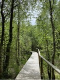 view gallery view galleryE7.4 km |  Bragphenn, Ormond, RLP, Germany Bragphenn, Ormond, RLP, Germany
in Non-Coastal Boardwalks Das Bragphenn ist ein Sattelregen-Hochmoor in der Nähe von Ormont
The Bragphenn is a saddle rain raised bog near Ormont posted by: Tillba location: Rheinland-Pfalz, Germany date approved: 10/16/2022 last visited: never |
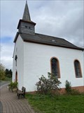
 view gallery view gallerySE7.6 km |  St. Jesu Namen, Wascheid, RLP, Germany St. Jesu Namen, Wascheid, RLP, Germany
in Roman Catholic Churches Kapelle in Wascheid
Chapel in Wascheid posted by: Tillba location: Rheinland-Pfalz, Germany date approved: 10/21/2022 last visited: never |
 view gallery view gallerySE7.6 km |  St. Jesu Namen, Gondenbrett-Wascheid, RLP, Germany St. Jesu Namen, Gondenbrett-Wascheid, RLP, Germany
in Deutsche Denkmallisten - German Monument Registers Kapelle in Wascheid Chapel in Wascheid posted by: Tillba location: Rheinland-Pfalz, Germany date approved: 10/17/2022 last visited: never |
 view gallery view galleryNE7.9 km | 27 - Losheim - DE in Cycling Routes Kyllradweg, Knotenpunkt 27, Kyllradweg L45a, Losheim posted by: TeamYakara location: Nordrhein-Westfalen, Germany date approved: 10/12/2019 last visited: never |
 view gallery view gallery N8.4 km N8.4 km
| 26 - Buchholz - BE in Cycling Routes Ravel 45a, Buchholz, Liège, Belgium posted by: TeamYakara location: Liège, Belgium date approved: 10/12/2019 last visited: 02/27/2023 |
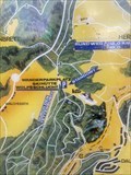
 view gallery view galleryE9 km | Wanderparkplatz Nr. 16, 'Standort', Olzheim, RLP, Germany in 'You Are Here' Maps Wanderkarte am Wanderparkplatz in Olzheim
Hiking map at the hiking car park in Olzheim posted by: Tillba location: Rheinland-Pfalz, Germany date approved: 11/02/2022 last visited: never |
 view gallery view gallerySE9.2 km | St. Dionysius, Gondenbrett, RLP, Germany in Roman Catholic Churches Kirche in Gondenbrett
Church in Gondenbrett posted by: Tillba location: Rheinland-Pfalz, Germany date approved: 10/24/2022 last visited: never |
 view gallery view galleryN9.5 km | 24 - Honsfeld - BE in Cycling Routes Ravel 45a, Honsfeld, L!ège, Belgium posted by: TeamYakara location: Liège, Belgium date approved: 10/12/2019 last visited: never |
 view gallery view galleryNE10 km | Kyllradweg, Hallschlag, Germany in 'You Are Here' Maps Cycle through areas of outstanding beauty on a tour through the Eifel, such as the maars of the Volcanic Eifel, the Eifel National Park, the Ferschweiler high plateau or the Volcano Park in the volcanic East Eifel.
Travelling along disused railway lines and rivers, you can choose from a large number of family-friendly, easy cycle tours, while passionate sports enthusiasts will enjoy cycling uphill to the summits to be rewarded with fantastic views. posted by: TeamYakara location: Rheinland-Pfalz, Germany date approved: 10/04/2019 last visited: never |
 view gallery view gallery NW10 km NW10 km
| 23 - Honsfeld - BE in Cycling Routes Ravel 45a, Honsfeld, Liège, Belgium posted by: TeamYakara location: Liège, Belgium date approved: 10/12/2019 last visited: never |
 view gallery view gallerySE10.1 km |  Eifel-Blick Gondenbrett Katzenkopf, Gondenbrett, RLP, Germany Eifel-Blick Gondenbrett Katzenkopf, Gondenbrett, RLP, Germany
in Orientation Tables Aussichtsplattform mit schönen Rund- und Weitblick
Viewing platform with beautiful panoramic and far-reaching views posted by: Tillba location: Rheinland-Pfalz, Germany date approved: 10/15/2022 last visited: never |
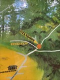
 view gallery view gallerySE10.3 km | Wanderparkplatz Nr. 15, Wolfsschlucht, Prüm, RLP, Germany in 'You Are Here' Maps Wanderkarte am Wanderparkplatz an der Wolfsschlucht
Hiking map at the hiking car park Wolfsschlucht posted by: Tillba location: Rheinland-Pfalz, Germany date approved: 11/03/2023 last visited: never |
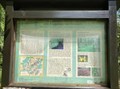
 view gallery view gallerySE11.4 km | Waldpfad Tettenbusch, Prüm, RLP, Germany in 'You Are Here' Maps Infotafel am Beginn des Waldpfads
Information board at the beginning of the forest trail posted by: Tillba location: Rheinland-Pfalz, Germany date approved: 09/26/2022 last visited: never |
|