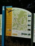
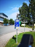
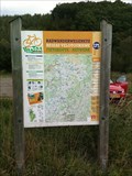
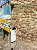
 view gallery view gallery SW6.3 km SW6.3 km
|   155 - Lommersweiler - BE 155 - Lommersweiler - BE
in Cycling Routes Vennbahn Route, Lommersweiler, Liège, Belgium posted by:  TeamYakara TeamYakara location: Liège, Belgium date approved: 10/12/2019 last visited: never |
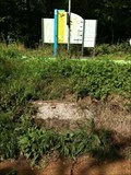 view gallery view gallerySW6.3 km |  ING Point De Mesure Ae31, Vennbahn, Lommersweiler ING Point De Mesure Ae31, Vennbahn, Lommersweiler
in Belgium Benchmarks Vennbahn, Lommersweiler, Liège posted by: TeamYakara location: Liège, Belgium date approved: 10/09/2019 last visited: never |
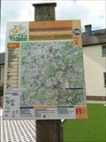
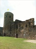
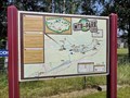 view gallery view gallery W6.4 km W6.4 km
|  MTB-Park St. Vith - St. Vith - Belgium MTB-Park St. Vith - St. Vith - Belgium
in Mountain Bike Trailheads A trail near the cycling-path in East-Belgium posted by: ColleIsarco location: Liège, Belgium date approved: 07/17/2020 last visited: never |
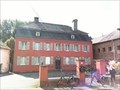
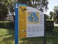 view gallery view galleryW6.4 km |  Vennbahn - St. Vith Belgium Vennbahn - St. Vith Belgium
in Rails to Trails A bike-trail connecting 3 countries posted by: ColleIsarco location: Liège, Belgium date approved: 09/30/2020 last visited: 03/04/2023 |
 view gallery view galleryW6.4 km | 48 - St. Vith - BE in Cycling Routes A cycling-route waymark is placed at 'Am Stellwerk' near the (former) railway-station of St. Vith. posted by: ColleIsarco location: Liège, Belgium date approved: 10/30/2020 last visited: never |
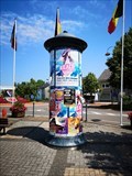 view gallery view galleryW6.6 km |  AC - St. Vith - Liège, Belgium AC - St. Vith - Liège, Belgium
in Advertising Columns An adverstising column in Belgian style in St. Vith posted by: ColleIsarco location: Liège, Belgium date approved: 08/18/2020 last visited: 03/04/2023 |
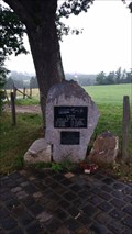 view gallery view galleryW8.7 km |  Halifax Memorial WW II, Saint Vith, Belgium Halifax Memorial WW II, Saint Vith, Belgium
in World War II Memorials / Monuments A small memorial for a downed Halifax crew. posted by:  MaaBo MaaBo location: Liège, Belgium date approved: 07/31/2016 last visited: 06/30/2019 |
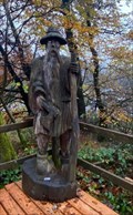 view gallery view gallery E10.3 km E10.3 km
|  Schwarzer Mann, Schneifel, Sellerich, RLP, Germany Schwarzer Mann, Schneifel, Sellerich, RLP, Germany
in Outside Wooden Display Carvings Holzfigur auf einer der höchsten Erhebungen in der Eifel / Wooden figure on one of the highest elevations in the Eifel (698 m). posted by: Tillba location: Rheinland-Pfalz, Germany date approved: 09/19/2022 last visited: never |
 view gallery view gallerySW10.8 km | 175 - Burg Reuland - BE in Cycling Routes Vennbahn route, Burg Reuland, Belgium posted by: TeamYakara location: Liège, Belgium date approved: 10/12/2019 last visited: never |
 view gallery view gallerySW11.3 km | 174 - Burg Reuland - BE in Cycling Routes Burg Reuland, Knooppunt 174 - Voie Verte posted by: TeamYakara location: Liège, Belgium date approved: 10/12/2019 last visited: never |
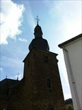
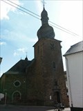 view gallery view gallerySW11.4 km |  Eglise Saint Stephanus, Burg Reuland Eglise Saint Stephanus, Burg Reuland
in Belgium Monument Registers Eglise Saint Stephanus, Burg Reuland posted by: TeamYakara location: Liège, Belgium date approved: 09/27/2019 last visited: never |
 view gallery view gallerySW11.4 km | ING Point De Mesure 56G55C1, Eglise Burg Reuland in Belgium Benchmarks Eglise Sint Stephanus, Burg Reuland posted by: TeamYakara location: Liège, Belgium date approved: 10/09/2019 last visited: never |
 view gallery view gallerySW11.4 km | ING Point De Mesure Ae18, Eglise Burg Reuland in Belgium Benchmarks Eglise Sint Stephanus, Burg Reuland posted by: TeamYakara location: Liège, Belgium date approved: 10/09/2019 last visited: never |
 view gallery view gallerySW11.4 km | Burg, Burg Reuland in Belgium Monument Registers Burg, Burg Reuland posted by: TeamYakara location: Liège, Belgium date approved: 09/28/2019 last visited: never |
 view gallery view gallerySW11.4 km | Haus Von-Orley, Burg Reuland in Belgium Monument Registers Haus Von Orley, Burg Reuland posted by: TeamYakara location: Liège, Belgium date approved: 09/28/2019 last visited: never |
 view gallery view gallerySW11.4 km | ING Point De Mesure 56G54C1,Burcht van Burg Reuland in Belgium Benchmarks Burcht Burg Reuland, Burg Reuland, Liège posted by: TeamYakara location: Liège, Belgium date approved: 10/09/2019 last visited: never |
 view gallery view galleryE11.6 km |  UTM 313244 / 5570835, Gondenbrett, Germany UTM 313244 / 5570835, Gondenbrett, Germany
in Permanent Geographic Coordinates Wegweiser im Wandergebiet Schwarzer Mann
Signposts in the Schwarzer Mann hiking area posted by: Tillba location: Rheinland-Pfalz, Germany date approved: 10/19/2022 last visited: never |
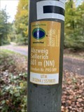 view gallery view galleryE11.6 km |  Abzweig Sellerich, Gondenbrett, Germany - 601m (NN) Abzweig Sellerich, Gondenbrett, Germany - 601m (NN)
in Elevation Signs Höhenangabe Abzweig Sellerich
Height indication Abzweig Sellerich posted by: Tillba location: Rheinland-Pfalz, Germany date approved: 10/18/2022 last visited: never |
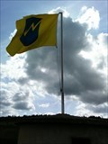
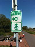
 view gallery view gallery NE12.1 km NE12.1 km
| 24 - Honsfeld - BE in Cycling Routes Ravel 45a, Honsfeld, L!ège, Belgium posted by: TeamYakara location: Liège, Belgium date approved: 10/12/2019 last visited: never |
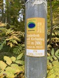 view gallery view galleryE12.1 km | Gondenbrett: südl. Kirchenberg, Gondenbrett, Germany - 531m (NN) in Elevation Signs Höhenangabe Schwarzer Mann
Height indication Schwarzer Mann posted by: Tillba location: Rheinland-Pfalz, Germany date approved: 10/18/2022 last visited: never |
 view gallery view galleryE12.1 km | UTM 313656 / 5570228, Gondenbrett, Germany in Permanent Geographic Coordinates Wegweiser im Wandergebiet Schwarzer Mann
Signposts in the Schwarzer Mann hiking area posted by: Tillba location: Rheinland-Pfalz, Germany date approved: 10/19/2022 last visited: never |
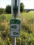
 view gallery view gallery N12.2 km N12.2 km
| 23 - Honsfeld - BE in Cycling Routes Ravel 45a, Honsfeld, Liège, Belgium posted by: TeamYakara location: Liège, Belgium date approved: 10/12/2019 last visited: never |
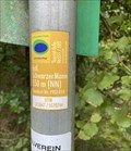
 view gallery view galleryE12.2 km | Schwarzer Mann, Schneifel/ Wascheid, Germany - 550m (NN) in Elevation Signs Höhenangabe Schwarzer Mann
Height indication Schwarzer Mann posted by: Tillba location: Rheinland-Pfalz, Germany date approved: 10/14/2022 last visited: never |
 view gallery view galleryE12.2 km | UTM 313847/ 5570744, Wascheid, Germany in Permanent Geographic Coordinates Wegweiser im Wandergebiet Schwarzer Mann
Signposts in the Schwarzer Mann hiking area posted by: Tillba location: Rheinland-Pfalz, Germany date approved: 10/14/2022 last visited: never |
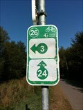 view gallery view galleryNE12.4 km | 26 - Buchholz - BE in Cycling Routes Ravel 45a, Buchholz, Liège, Belgium posted by: TeamYakara location: Liège, Belgium date approved: 10/12/2019 last visited: 02/27/2023 |
|