 view gallery view gallery W12.9 km W12.9 km
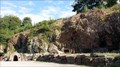
|   Grube Wilhelmine - Kupferbergwerk Sommerkahl, Bayern, Germany Grube Wilhelmine - Kupferbergwerk Sommerkahl, Bayern, Germany
in Mines Old Copper Mine for Visitors posted by:  datenhamster datenhamster location: Bayern, Germany date approved: 08/15/2016 last visited: never |
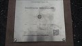 view gallery view galleryW13.4 km |  Geodätischer Referenzpunkt Westerngrund, Bayern, Germany - N 50° 06.800 E 09° 15.150 Geodätischer Referenzpunkt Westerngrund, Bayern, Germany - N 50° 06.800 E 09° 15.150
in Permanent Geographic Coordinates Geodätischer Referenzpunkt Westerngrund
Die Koordinaten sind identisch mit den Koordinaten des EU-Mittelpunktes (Stand Mai 2014). posted by: datenhamster location: Bayern, Germany date approved: 08/24/2016 last visited: never |
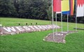 view gallery view galleryW13.4 km |  Mittelpunkt der EU - Westerngrund, Bayern, Germany Mittelpunkt der EU - Westerngrund, Bayern, Germany
in Geographical Centers Geographic centre of the European Union posted by: datenhamster location: Bayern, Germany date approved: 08/14/2016 last visited: never |
 view gallery view gallery SE16.1 km SE16.1 km
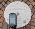
| N 49° 59.7497' E 9° 34.4099' - Geodätischer Referenzpunkt — Lohr am Main, Germany in Permanent Geographic Coordinates Geodetic reference point determined by the Bayerische Vermessungsverwaltung (Bavarian Surveying Administration) posted by:  prussel prussel location: Bayern, Germany date approved: 06/29/2017 last visited: never |
 view gallery view gallerySE16.1 km |  163,1 m ü.NN - Geodätischer Referenzpunkt — Lohr am Main, Germany 163,1 m ü.NN - Geodätischer Referenzpunkt — Lohr am Main, Germany
in Elevation Signs Geodetic reference point determined by the Bayerische Vermessungsverwaltung (Bavarian Surveying Administration) showing the coordinates and a height of 163,1 m ü.NN posted by: prussel location: Bayern, Germany date approved: 06/27/2017 last visited: never |
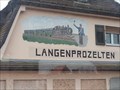 view gallery view gallery E16.7 km E16.7 km
|  Train and Conductor - Langenprozelten/Gemünden / Bayern/ Deutschland Train and Conductor - Langenprozelten/Gemünden / Bayern/ Deutschland
in Murals A nice train on a house wall. posted by: Bianka11 location: Bayern, Germany date approved: 03/24/2014 last visited: never |
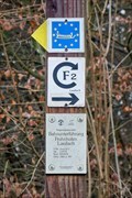
 view gallery view galleryW16.9 km | 291 m ü. NN - Hangelstein Geiselbach — Geiselbach, Germany in Elevation Signs Altitude and UTM Coordinates at the signpost "Hangelstein Geiselbach" posted by: prussel location: Bayern, Germany date approved: 01/25/2023 last visited: never |
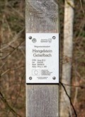 view gallery view galleryW16.9 km | 32U 514722 5553513 - Hangelstein Geiselbach — Geiselbach, Germany in Permanent Geographic Coordinates Altitude and UTM Coordinates at the signpost "Hangelstein Geiselbach" posted by: prussel location: Bayern, Germany date approved: 01/25/2023 last visited: never |
 view gallery view galleryW16.9 km | 32U 514682 5553739 - Wetterschutzhütte Geiselbach — Geiselbach, Germany in Permanent Geographic Coordinates Altitude and UTM Coordinates at the signpost "Wetterschutzhütte Geiselbach" posted by: prussel location: Bayern, Germany date approved: 01/25/2023 last visited: never |
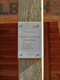 view gallery view galleryW16.9 km | 260 m ü. NN - Wetterschutzhütte Geiselbach — Geiselbach, Germany in Elevation Signs Altitude and UTM Coordinates at the signpost "Wetterschutzhütte Geiselbach" posted by: prussel location: Bayern, Germany date approved: 01/25/2023 last visited: never |
 view gallery view gallery S17.1 km S17.1 km
|  Wetterhexe - Hotel Spechtshaardt - Rothenbuch, Bavaria, Germany Wetterhexe - Hotel Spechtshaardt - Rothenbuch, Bavaria, Germany
in Unique Weathervanes Nice weather witch on the roof of the hotel "Spechtshaardt" in Rothenbuch. posted by: lumbricus location: Bayern, Germany date approved: 02/08/2017 last visited: never |
 view gallery view gallery SW17.4 km SW17.4 km
|  Zugunglück bei Frohnhofen — Laufach, Germany Zugunglück bei Frohnhofen — Laufach, Germany
in Railway Disaster Sites Here a memorial plaque commemorates the train accident near Frohnhofen on May 25, 1946 posted by: prussel location: Bayern, Germany date approved: 01/17/2023 last visited: never |
 view gallery view gallerySW17.5 km | 168 m ü. NN - Bahnunterführung Frohnhofen Laufach — Laufach, Germany in Elevation Signs Altitude and UTM Coordinates at the signpost "Bahnunterführung Frohnhofen Laufach" posted by: prussel location: Bayern, Germany date approved: 01/17/2023 last visited: never |
 view gallery view gallerySW17.5 km | 32U 518775 5539078 - Bahnunterführung Frohnhofen Laufach — Laufach, Germany in Permanent Geographic Coordinates Altitude and UTM Coordinates at the signpost "Bahnunterführung Frohnhofen Laufach" posted by: prussel location: Bayern, Germany date approved: 01/04/2023 last visited: never |
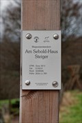 view gallery view gallerySW17.5 km | 32U 519210 5538585 - Am Sebold-Haus Steiger — Bessenbach, Germany in Permanent Geographic Coordinates Altitude and UTM Coordinates at the signpost "Am Sebold-Haus Steiger" posted by: prussel location: Bayern, Germany date approved: 01/04/2023 last visited: never |
 view gallery view gallerySW17.5 km | 263 m ü. NN - Am Sebold-Haus Steiger — Bessenbach, Germany in Elevation Signs Altitude and UTM Coordinates at the signpost "Am Sebold-Haus Steiger" posted by: prussel location: Bayern, Germany date approved: 01/17/2023 last visited: never |
 view gallery view gallerySW17.9 km | 258 m ü. NN - Kapelle Steiger — Bessenbach, Germany in Elevation Signs Altitude and UTM Coordinates at the signpost "Kapelle Steiger" posted by: prussel location: Bayern, Germany date approved: 01/17/2023 last visited: never |
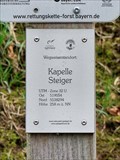 view gallery view gallerySW17.9 km | 32U 519054 5538294 - Kapelle Steiger — Bessenbach, Germany in Permanent Geographic Coordinates Altitude and UTM Coordinates at the signpost "Kapelle Steiger" posted by: prussel location: Bayern, Germany date approved: 01/04/2023 last visited: never |
 view gallery view gallerySW17.9 km |  Marienkapelle Steiger — Bessenbach, Germany Marienkapelle Steiger — Bessenbach, Germany
in Waychapels The Chapel from the 18th century stands on the old trade route from Aschaffenburg to Lohr posted by: prussel location: Bayern, Germany date approved: 01/05/2023 last visited: never |
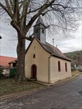 view gallery view gallerySW17.9 km |  Marienkapelle Steiger — Bessenbach, Germany Marienkapelle Steiger — Bessenbach, Germany
in Deutsche Denkmallisten - German Monument Registers The Chapel from the 18th century stands on the old trade route from Aschaffenburg to Lohr posted by: prussel location: Bayern, Germany date approved: 01/04/2023 last visited: never |
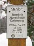 view gallery view gallerySW17.9 km | 32U 5194 55378 — Abzweig Steiger Kurfürstenweg - Bessenbach, Germany in Permanent Geographic Coordinates Altitude and UTM Coordinates at the signpost "Abzweig Steiger Kurfürstenweg" near Bessenbach posted by: prussel location: Bayern, Germany date approved: 02/13/2019 last visited: never |
 view gallery view gallerySW17.9 km | 251m. ü. NN - Abzweig Steiger Kurfürstenweg — Bessenbach, Germany in Elevation Signs Altitude and UTM Coordinates at the signpost "Abzweig Steiger Kurfürstenweg" near Bessenbach posted by: prussel location: Bayern, Germany date approved: 03/11/2019 last visited: never |
 view gallery view galleryW18.3 km | 228 m ü. NN - Näßlichgrund Geiselbach — Geiselbach, Germany in Elevation Signs Altitude and UTM Coordinates at the signpost "Näßlichgrund Geiselbach" posted by: prussel location: Bayern, Germany date approved: 01/25/2023 last visited: never |
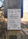 view gallery view galleryW18.3 km | 32U 513333 5553941 - Näßlichgrund Geiselbach — Geiselbach, Germany in Permanent Geographic Coordinates Altitude and UTM Coordinates at the signpost "Näßlichgrund Geiselbach" posted by: prussel location: Bayern, Germany date approved: 01/25/2023 last visited: never |
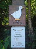 view gallery view gallerySW19.2 km | 32U 521576 5534716 — Gänswewg - Waldaschaff, Germany in Permanent Geographic Coordinates Altitude and UTM Coordinates at the signpost "Gänsweg Waldaschaff" posted by: prussel location: Bayern, Germany date approved: 02/13/2019 last visited: never |
|