 view gallery view gallery E3.7 km E3.7 km
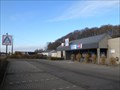
|   Aldi Store Saint-Hubert Belgium Aldi Store Saint-Hubert Belgium
in ALDI Stores Aldi Store Saint-Hubert Belgium posted by:  Alfredo4 Alfredo4 location: Luxembourg, Belgium date approved: 11/20/2011 last visited: never |
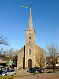
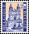 view gallery view galleryE4 km |  Basilique Saint-Hubert - Saint-Hubert - Belgique Basilique Saint-Hubert - Saint-Hubert - Belgique
in Philatelic Photographs [FR] Timbre représentant la basilique Saint-Hubert, Église abbatiale de l'abbaye de Saint-Pierre en Ardenne (687-1797). [EN] Stamp picturing Saint-Hubert basilica, abbey church of Saint-Pierre abbey in Ardenne (687-1797). posted by: PaulLassiter location: Luxembourg, Belgium date approved: 12/31/2020 last visited: never |
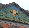 view gallery view galleryE4 km |  1729 - Abbaye de Saint-Hubert - Saint-Hubert, Belgique 1729 - Abbaye de Saint-Hubert - Saint-Hubert, Belgique
in Chronograms [FR] Chronogramme décoratif et coloré en haut du portail occidental du palais abbatial. [EN] Decorative and colourful chronogram at the top of the western portal of the abbot's palace. posted by: PaulLassiter location: Luxembourg, Belgium date approved: 01/05/2021 last visited: never |
 view gallery view galleryE4 km |  Abbaye de Saint-Hubert - Saint-Hubert - Belgique Abbaye de Saint-Hubert - Saint-Hubert - Belgique
in Wikipedia Entries [FR] Ancienne abbaye fondée vers 687 et devenue bénédictine en 817. [EN] Former abbey founded around 687 and became Benedictine in 817. posted by: PaulLassiter location: Luxembourg, Belgium date approved: 01/01/2021 last visited: never |
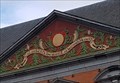 view gallery view galleryE4.2 km | 1729 - Abbaye de Saint-Hubert - Saint-Hubert, Belgique in Chronograms [FR] Chronogramme décoratif et coloré en haut du portail oriental du palais abbatial. [EN] Decorative and colourful chronogram at the top of the eastern portal of the abbot's palace. posted by: PaulLassiter location: Luxembourg, Belgium date approved: 01/05/2021 last visited: never |
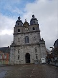 view gallery view galleryE4.2 km | Basilique Saint-Hubert - Saint-Hubert - Belgique in Wikipedia Entries [FR] Ancienne église de l'abbaye bénédictine fondée au VIIe siècle, reconstruite en 1526.[EN] Former church of the Benedictine abbey founded in the 7th century, rebuilt in 1526. posted by: PaulLassiter location: Luxembourg, Belgium date approved: 12/30/2020 last visited: never |
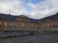 view gallery view galleryE4.2 km |  Abbaye de Saint-Hubert - Saint-Hubert - Belgique Abbaye de Saint-Hubert - Saint-Hubert - Belgique
in Abbeys, Convents and Monasteries [FR] Ancienne abbaye fondée vers 687 et devenue bénédictine en 817. [EN] Former abbey founded around 687 and became Benedictine in 817. posted by: PaulLassiter location: Luxembourg, Belgium date approved: 01/03/2021 last visited: never |
 view gallery view gallery NE5.8 km NE5.8 km
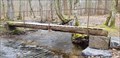
|  Pont Mauricy - Saint-Hubert, Luxembourg, Belgique Pont Mauricy - Saint-Hubert, Luxembourg, Belgique
in Hiking Path Footbridges [FR] Passerelle permettant d'enjamber le ruisseau de la Masblette [EN] Footbridge to cross the Masblette stream. posted by: Waldog location: Luxembourg, Belgium date approved: 04/05/2019 last visited: 11/29/2021 |
 view gallery view gallery N6 km N6 km
| Fourneau Saint-Michel - Saint-Hubert - Belgique in Wikipedia Entries [FR] Ancien fourneau de l’abbaye de Saint-Hubert. [EN] Former furnace of the abbey of Saint-Hubert. posted by: PaulLassiter location: Luxembourg, Belgium date approved: 11/29/2021 last visited: never |
 view gallery view galleryN6 km |  Ancien fourneau Saint-Michel et ses bâtiments - Saint-Hubert - Belgique Ancien fourneau Saint-Michel et ses bâtiments - Saint-Hubert - Belgique
in Belgium Monument Registers [FR] Ancien fourneau de l’abbaye de Saint-Hubert. [EN] Former furnace of the abbey of Saint-Hubert. posted by: PaulLassiter location: Luxembourg, Belgium date approved: 11/29/2021 last visited: never |
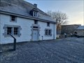
 view gallery view gallery NW12.1 km NW12.1 km
|  Chateau de Resteigne - Tellin - Belgique. 180m Chateau de Resteigne - Tellin - Belgique. 180m
in Elevation Signs Signe d'altitude du lieu Château de Resteigne posted by: franketmuriel location: Luxembourg, Belgium date approved: 10/22/2017 last visited: 03/17/2019 |
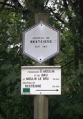
 view gallery view gallery W13 km W13 km
| Passerelle de Chafté-Louis - Libin - Belgique, 260 m. in Elevation Signs [FR] Signal d'altitude près de la passerelle sur une des promenades entre les rivières Lesse et Lomme. [EN] Altitude signal near the bridge on one of the parkways between the Lesse and Lomme rivers. posted by: PaulLassiter location: Luxembourg, Belgium date approved: 07/16/2019 last visited: never |
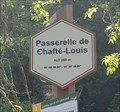 view gallery view galleryW13 km |  49° 59' 30,96" 05° 08' 39,89" - Passerelle de Chafté-Louis - Libin - Belgique 49° 59' 30,96" 05° 08' 39,89" - Passerelle de Chafté-Louis - Libin - Belgique
in Permanent Geographic Coordinates [FR] Coordonnées géographiques DMS se trouvant sur le panneau de randonnée. [EN] Geographical coordinates DMS located on the hiking sign. posted by: PaulLassiter location: Luxembourg, Belgium date approved: 07/16/2019 last visited: never |
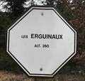 view gallery view galleryW13.4 km | Les Erguinaux. Wellin, Belgique. 260 m. in Elevation Signs Signe d'altitude Les Erguinaux posted by: franketmuriel location: Luxembourg, Belgium date approved: 04/01/2020 last visited: never |
 view gallery view galleryW13.7 km | Point de vue du Belvédère. Wellin, Belgique. 335 m. in Elevation Signs Signe d'altitude Point de vue du Belvédère. posted by: franketmuriel location: Luxembourg, Belgium date approved: 04/01/2020 last visited: never |
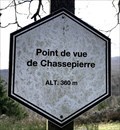 view gallery view galleryW14.8 km | Point de vue de Chassepierre. Wellin, Belgique. 360 m. in Elevation Signs Signe d'altitude du Point de vue de Chassepierre. posted by: franketmuriel location: Luxembourg, Belgium date approved: 04/01/2020 last visited: never |
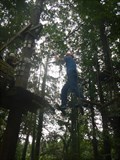 view gallery view galleryNW15.9 km |  Climbing parcours camping Roptai - Ave-et-Auffe, Belgium Climbing parcours camping Roptai - Ave-et-Auffe, Belgium
in Ropes Course The camping Roptai has a fun climbing parcours posted by: Becktracker location: Namur, Belgium date approved: 03/03/2021 last visited: 08/19/2016 |
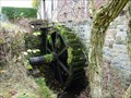
 view gallery view galleryNW16.4 km | Domaine du Vieux Moulin - Eprave - Belgique in Wikipedia Entries [FR]Moulin à eau du XVe siècle restauré en 1993. [EN] 15th century watermill restored in 1993. posted by: PaulLassiter location: Luxembourg, Belgium date approved: 12/20/2020 last visited: never |
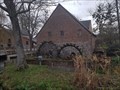 view gallery view galleryNW16.4 km |  Domaine du Vieux Moulin - Eprave - Belgique Domaine du Vieux Moulin - Eprave - Belgique
in Water Mills FR] Moulin à eau du XVe siècle restauré en 1993. [EN] 15th century watermill restored in 1993. posted by: PaulLassiter location: Luxembourg, Belgium date approved: 12/21/2020 last visited: never |
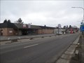 view gallery view galleryNW16.6 km | Aldi Store Rochefort Belgium in ALDI Stores Aldi Store Rochefort posted by: Alfredo4 location: Namur, Belgium date approved: 12/04/2011 last visited: 04/19/2014 |
 view gallery view galleryN16.6 km |  Vous êtes ici - Prés de la Wamme réserve naturelle RNOB - Hargimont (Marche-en-Famenne) Vous êtes ici - Prés de la Wamme réserve naturelle RNOB - Hargimont (Marche-en-Famenne)
in 'You Are Here' Maps L'indication "vous êtes ici" se trouve sur un panneau d'information de la réserve naturelle privée RNOB posted by: franketmuriel location: Luxembourg, Belgium date approved: 01/15/2018 last visited: never |
 view gallery view galleryN16.6 km | Prés de la Wamme - Hargimont (Marche-en-Famenne) - Belgique 260m in Elevation Signs Signe d'altitude du lieu Prés de la Wamme posted by: franketmuriel location: Luxembourg, Belgium date approved: 01/15/2018 last visited: never |
 view gallery view galleryW16.7 km | Moulin de Lomprez - Lomprez, Belgium in Water Mills A Water Mill located at Vieille-Route 15 in Lomprez (Wellin), Belgium. The mill was initially built in the 12th century and was used for milling grain. It was also part of a defence line. It is restored in 1996. It is driven by a water wheel of 4m. posted by: Hibje location: Luxembourg, Belgium date approved: 11/24/2009 last visited: 08/14/2018 |
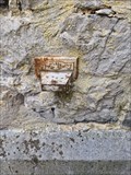 view gallery view galleryW16.7 km |  NGI Meetpunt: Thi12 - Lomprez NGI Meetpunt: Thi12 - Lomprez
in Belgium Benchmarks A Belgium benchmark at the church in Lomprez posted by: kallehaugerne location: Luxembourg, Belgium date approved: 10/08/2023 last visited: never |
 view gallery view galleryN17.1 km | IGN Pt de mesure: 59C59C1 HARGIMONT (Marche-en-Famenne) in Belgium Benchmarks IGN Pt de mesure: 59C59C1 - église "Saint-Gobert" HARGIMONT (Marche-en-Famenne) posted by: franketmuriel location: Luxembourg, Belgium date approved: 01/17/2018 last visited: 08/14/2018 |
|