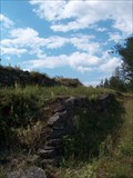
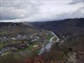
 view gallery view gallery SW11.3 km SW11.3 km
|   Château-Le-duc Château-Le-duc
in Castles Ruine du Château-le-Duc posted by:  habot habot location: Belgium date approved: 08/16/2005 last visited: 07/25/2007 |
 view gallery view gallery NW13.4 km NW13.4 km
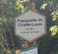
|  49° 59' 30,96" 05° 08' 39,89" - Passerelle de Chafté-Louis - Libin - Belgique 49° 59' 30,96" 05° 08' 39,89" - Passerelle de Chafté-Louis - Libin - Belgique
in Permanent Geographic Coordinates [FR] Coordonnées géographiques DMS se trouvant sur le panneau de randonnée. [EN] Geographical coordinates DMS located on the hiking sign. posted by: PaulLassiter location: Luxembourg, Belgium date approved: 07/16/2019 last visited: never |
 view gallery view galleryNW13.4 km |  Passerelle de Chafté-Louis - Libin - Belgique, 260 m. Passerelle de Chafté-Louis - Libin - Belgique, 260 m.
in Elevation Signs [FR] Signal d'altitude près de la passerelle sur une des promenades entre les rivières Lesse et Lomme. [EN] Altitude signal near the bridge on one of the parkways between the Lesse and Lomme rivers. posted by: PaulLassiter location: Luxembourg, Belgium date approved: 07/16/2019 last visited: never |
 view gallery view gallerySW14.6 km | Bouillon in Castles Château de Godefroid de Bouillon. posted by: habot location: Belgium date approved: 08/16/2005 last visited: 03/13/2023 |
 view gallery view gallery W17.1 km W17.1 km
| La 49° 49' 28" Long 04° 59' 41" - Crêtes de Frahan - Bouillon, Belgique in Permanent Geographic Coordinates [FR] Coordonnées géographiques DMS se trouvant sur le panneau de randonnée. [EN] Geographical coordinates DMS located on the hiking sign. posted by: PaulLassiter location: Luxembourg, Belgium date approved: 12/18/2020 last visited: never |
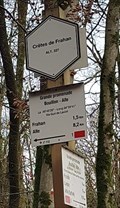 view gallery view galleryW17.1 km | Crêtes de Frahan - Bouillon - Belgique, 227 m in Elevation Signs [FR] Signal d'altitude au pied des crêtes de Frahan. [EN] Altitude signal at the foot of the crests of Frahan. posted by: PaulLassiter location: Luxembourg, Belgium date approved: 12/05/2020 last visited: never |
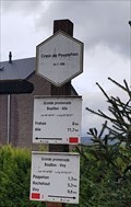 view gallery view gallerySW17.4 km | Croix de Poupehan - Corbion - Belgique, 356 m in Elevation Signs [FR] Signal d'altitude situé près d'un croix chrétienne au début de la rue éponyme. [EN] 78 / 5000
Résultats de traduction
Altitude signal located near a Christian cross at the beginning of the eponymous street. posted by: PaulLassiter location: Luxembourg, Belgium date approved: 12/05/2020 last visited: never |
 view gallery view gallerySW17.4 km | Lat 49° 48' 04" - Long 05° 00' 27" - Croix de Poupehan - Corbion, Belgique in Permanent Geographic Coordinates FR] Coordonnées géographiques DMS se trouvant sur le panneau de randonnée. [EN] Geographical coordinates DMS located on the hiking sign. posted by: PaulLassiter location: Luxembourg, Belgium date approved: 12/18/2020 last visited: never |
 view gallery view gallerySW17.5 km |  La Chaire à Prêcher - Bouillon - Belgique La Chaire à Prêcher - Bouillon - Belgique
in Urban Legends and Superstitions [FR] Piton rocheux dominant largement la vallée de la Semois et surplombant d'une hauteur de 100 m le village de Poupehan.[EN] A rocky peak largely dominating the valley of Semois River and overhanging the village of Poupehan from a height of 100m. posted by: PaulLassiter location: Luxembourg, Belgium date approved: 12/18/2020 last visited: never |
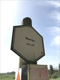 view gallery view gallery E17.7 km E17.7 km
| 470 m - Marnau - Neufchâteau - Belgique in Elevation Signs Signe d'altitude Marnau posted by: franketmuriel location: Luxembourg, Belgium date approved: 04/23/2019 last visited: 03/13/2023 |
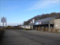 view gallery view gallery NE19.6 km NE19.6 km
|  Aldi Store Saint-Hubert Belgium Aldi Store Saint-Hubert Belgium
in ALDI Stores Aldi Store Saint-Hubert Belgium posted by: Alfredo4 location: Luxembourg, Belgium date approved: 11/20/2011 last visited: never |
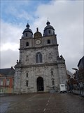
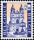 view gallery view galleryNE19.6 km |  Basilique Saint-Hubert - Saint-Hubert - Belgique Basilique Saint-Hubert - Saint-Hubert - Belgique
in Philatelic Photographs [FR] Timbre représentant la basilique Saint-Hubert, Église abbatiale de l'abbaye de Saint-Pierre en Ardenne (687-1797). [EN] Stamp picturing Saint-Hubert basilica, abbey church of Saint-Pierre abbey in Ardenne (687-1797). posted by: PaulLassiter location: Luxembourg, Belgium date approved: 12/31/2020 last visited: never |
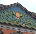 view gallery view galleryNE19.8 km |  1729 - Abbaye de Saint-Hubert - Saint-Hubert, Belgique 1729 - Abbaye de Saint-Hubert - Saint-Hubert, Belgique
in Chronograms [FR] Chronogramme décoratif et coloré en haut du portail occidental du palais abbatial. [EN] Decorative and colourful chronogram at the top of the western portal of the abbot's palace. posted by: PaulLassiter location: Luxembourg, Belgium date approved: 01/05/2021 last visited: never |
 view gallery view galleryNE19.8 km |  Basilique Saint-Hubert - Saint-Hubert - Belgique Basilique Saint-Hubert - Saint-Hubert - Belgique
in Wikipedia Entries [FR] Ancienne église de l'abbaye bénédictine fondée au VIIe siècle, reconstruite en 1526.[EN] Former church of the Benedictine abbey founded in the 7th century, rebuilt in 1526. posted by: PaulLassiter location: Luxembourg, Belgium date approved: 12/30/2020 last visited: never |
 view gallery view galleryNE19.8 km | Abbaye de Saint-Hubert - Saint-Hubert - Belgique in Wikipedia Entries [FR] Ancienne abbaye fondée vers 687 et devenue bénédictine en 817. [EN] Former abbey founded around 687 and became Benedictine in 817. posted by: PaulLassiter location: Luxembourg, Belgium date approved: 01/01/2021 last visited: never |
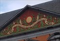 view gallery view galleryNE19.8 km | 1729 - Abbaye de Saint-Hubert - Saint-Hubert, Belgique in Chronograms [FR] Chronogramme décoratif et coloré en haut du portail oriental du palais abbatial. [EN] Decorative and colourful chronogram at the top of the eastern portal of the abbot's palace. posted by: PaulLassiter location: Luxembourg, Belgium date approved: 01/05/2021 last visited: never |
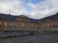 view gallery view galleryNE19.8 km |  Abbaye de Saint-Hubert - Saint-Hubert - Belgique Abbaye de Saint-Hubert - Saint-Hubert - Belgique
in Abbeys, Convents and Monasteries [FR] Ancienne abbaye fondée vers 687 et devenue bénédictine en 817. [EN] Former abbey founded around 687 and became Benedictine in 817. posted by: PaulLassiter location: Luxembourg, Belgium date approved: 01/03/2021 last visited: never |
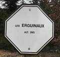 view gallery view gallery N20.3 km N20.3 km
| Les Erguinaux. Wellin, Belgique. 260 m. in Elevation Signs Signe d'altitude Les Erguinaux posted by: franketmuriel location: Luxembourg, Belgium date approved: 04/01/2020 last visited: never |
 view gallery view galleryNW20.4 km |  N50 E005 - Haut-Fays, Belgium N50 E005 - Haut-Fays, Belgium
in Confluence Spots An easy accessible Confluence Point in a forest near Haut-Fays, Belgium. posted by: Hibje location: Namur, Belgium date approved: 11/23/2009 last visited: 04/07/2022 |
 view gallery view galleryN20.8 km | Point de vue du Belvédère. Wellin, Belgique. 335 m. in Elevation Signs Signe d'altitude Point de vue du Belvédère. posted by: franketmuriel location: Luxembourg, Belgium date approved: 04/01/2020 last visited: never |
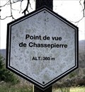 view gallery view galleryN20.8 km | Point de vue de Chassepierre. Wellin, Belgique. 360 m. in Elevation Signs Signe d'altitude du Point de vue de Chassepierre. posted by: franketmuriel location: Luxembourg, Belgium date approved: 04/01/2020 last visited: never |
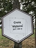 view gallery view galleryNW22.5 km | Signe d'altitude du lieu Croix Victoire - Wellin - Belgique - 350 m in Elevation Signs Signe d'altitude du lieu Croix Victoire posted by: franketmuriel location: Luxembourg, Belgium date approved: 08/15/2018 last visited: never |
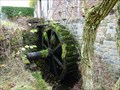 view gallery view galleryN23.5 km |  Moulin de Lomprez - Lomprez, Belgium Moulin de Lomprez - Lomprez, Belgium
in Water Mills A Water Mill located at Vieille-Route 15 in Lomprez (Wellin), Belgium. The mill was initially built in the 12th century and was used for milling grain. It was also part of a defence line. It is restored in 1996. It is driven by a water wheel of 4m. posted by: Hibje location: Luxembourg, Belgium date approved: 11/24/2009 last visited: 08/14/2018 |
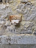 view gallery view galleryN23.5 km |  NGI Meetpunt: Thi12 - Lomprez NGI Meetpunt: Thi12 - Lomprez
in Belgium Benchmarks A Belgium benchmark at the church in Lomprez posted by: kallehaugerne location: Luxembourg, Belgium date approved: 10/08/2023 last visited: never |
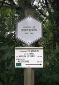 view gallery view galleryN23.5 km | Chateau de Resteigne - Tellin - Belgique. 180m in Elevation Signs Signe d'altitude du lieu Château de Resteigne posted by: franketmuriel location: Luxembourg, Belgium date approved: 10/22/2017 last visited: 03/17/2019 |
|