 view gallery view gallery N17.4 km N17.4 km
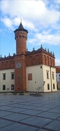
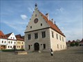
|   Town Hall of Tarnów, Poland Town Hall of Tarnów, Poland
in Renaissance Architecture Renaissance Town Hall in Tarnów, Poland is a visiting-worthy building and one of the symbols of the city. posted by:  xMt xMt location: Małopolskie, Poland date approved: 03/17/2024 last visited: never |
 view gallery view gallery E33.5 km E33.5 km
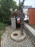
|  Studnia publiczna nr 7 - Jaslo, malopolskie Studnia publiczna nr 7 - Jaslo, malopolskie
in Hand Operated Water Pumps historic hand-operated pump in Jaslo posted by: okrutnyb location: Małopolskie, Poland date approved: 08/03/2023 last visited: never |
 view gallery view gallery W45.4 km W45.4 km
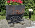
|  Salt Mine Cart - Bochnia, Poland Salt Mine Cart - Bochnia, Poland
in Static Train Cars Salt Mine Cart on display on the side of the street of Bochnia posted by: sernikk location: Małopolskie, Poland date approved: 11/01/2021 last visited: never |
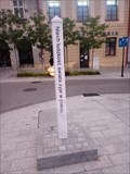 view gallery view galleryW45.5 km |  Rynek Glówny, Peace Pole - Wieliczka, PL Rynek Glówny, Peace Pole - Wieliczka, PL
in Peace Poles Peace Pole on the main square in Bochnia posted by: okrutnyb location: Małopolskie, Poland date approved: 09/29/2023 last visited: never |
 view gallery view galleryW45.5 km | Salt Mine Cart - Szyb Regis - Bochnia, Poland in Static Train Cars Salt Mine Cart on display on the side of the street of Bochnia posted by: sernikk location: Małopolskie, Poland date approved: 11/01/2021 last visited: 09/14/2023 |
 view gallery view gallery SW52.3 km SW52.3 km
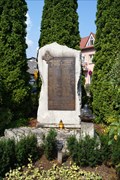
|  Monument for the Residents of Piwniczna killed in WW II - Piwniczna-Zdrój, Poland Monument for the Residents of Piwniczna killed in WW II - Piwniczna-Zdrój, Poland
in World War II Memorials / Monuments A monument to remember the residents of Piwniczna killed in World War II posted by: PISA-caching location: Małopolskie, Poland date approved: 08/17/2015 last visited: never |
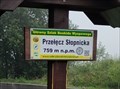 view gallery view gallerySW56.2 km |  759m - Przelecz Slopnicka - Beskid Wyspowy - Malopolskie, Poland 759m - Przelecz Slopnicka - Beskid Wyspowy - Malopolskie, Poland
in Elevation Signs Przelecz Slopnicka elevation sign. posted by: sernikk location: Małopolskie, Poland date approved: 10/28/2021 last visited: 03/15/2024 |
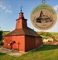
 view gallery view gallery SE56.6 km SE56.6 km
|  No.357, Jedlinka, SK No.357, Jedlinka, SK
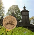
in Tourist Stamps Photos Slovak wooden stamp No.357 from series of DREVENE KOSTOLIKY (Wooden Churches) depicts Greek Catholic church of Protection of the Mother of God, built in 1763, in village Jedlinka, near Bardejov, North-East Slovakia. posted by: Rikitan location: Prešovský kraj, Slovakia date approved: 06/13/2014 last visited: never |
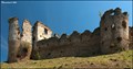
 view gallery view gallery S59.4 km S59.4 km
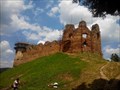
|  Zborovský hrad - Slovensko Zborovský hrad - Slovensko
in Satellite Imagery Oddities Ruins of Zborov Castle (Zborovský hrad, also called Makovica) are situated near the village of Zborov in East Slovakia. posted by:  Noe1 Noe1 location: Prešovský kraj, Slovakia date approved: 01/19/2017 last visited: never |
 view gallery view galleryS59.4 km |  Zborov Castle / Hrad Zborov (East Slovakia) Zborov Castle / Hrad Zborov (East Slovakia)
in Castles Ruins of Zborov Castle are situated near the village of Zborov in East Slovakia. The oldest written mention of the castle comes from the 13th century but older fortification had existed before. posted by: Dorcadion Team location: Prešovský kraj, Slovakia date approved: 06/21/2009 last visited: 05/16/2013 |
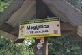 view gallery view galleryW59.5 km | 1170m - Mogielica - Beskid Wyspowy - Malopolskie, Poland in Elevation Signs Mogielica, the highest peak of Beskid Wyspowy posted by: sernikk location: Małopolskie, Poland date approved: 10/28/2021 last visited: 03/15/2024 |
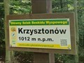 view gallery view gallerySW62.6 km | 1012m - Krzysztonów - Beskid Wyspowy - Malopolskie, Poland in Elevation Signs Krzysztonów elevation sign posted by: sernikk location: Małopolskie, Poland date approved: 10/28/2021 last visited: 09/15/2023 |
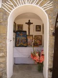 view gallery view gallerySW62.8 km |  Kaplnka sv. Kriza / Chaple of st. Cross Kaplnka sv. Kriza / Chaple of st. Cross
in Outdoor Altars Greckokatolicka kaplnka sv. Kriza na kopci Vabec. Kompletne zrenovovana v roku 2008 a znovu posvatena 10. augusta 2008.
Byzantine-Catholic chapel of st. Cross. Completely renewed in 2008 and consecrated on August 10th 2008. posted by: coldeaux location: Prešovský kraj, Slovakia date approved: 10/13/2008 last visited: never |
 view gallery view galleryS63.7 km | No.358, Krivé, SK in Tourist Stamps Photos Slovak wooden stamp No.358 from series of DREVENE KOSTOLIKY (Wooden Churches) depicts Greek Catholic church of the Holy Evangelist Luke, built in 1826, in village Krivé, near Bardejov, North-East Slovakia. posted by: Rikitan location: Prešovský kraj, Slovakia date approved: 05/30/2014 last visited: never |
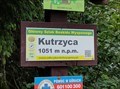 view gallery view gallerySW63.7 km | 1051m - Kutrzyca - Beskid Wyspowy - Malopolskie, Poland in Elevation Signs Kutrzyca elevation sign posted by: sernikk location: Małopolskie, Poland date approved: 10/28/2021 last visited: never |
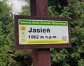 view gallery view gallerySW64.1 km | 1062m - Jasien - Beskid Wyspowy - Malopolskie, Poland in Elevation Signs Jasien elevation sign posted by: sernikk location: Małopolskie, Poland date approved: 10/28/2021 last visited: never |
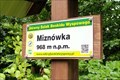 view gallery view gallerySW64.4 km | 968m - Miznówka - Beskid Wyspowy - Malopolskie, Poland in Elevation Signs Miznówka elevation sign posted by: sernikk location: Małopolskie, Poland date approved: 10/28/2021 last visited: never |
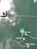 view gallery view gallerySW64.7 km |  "You are here" Szczawnica, Poland "You are here" Szczawnica, Poland
in 'You Are Here' Maps A ¨You Are Here¨ cycling route map. posted by: davidb11 location: Małopolskie, Poland date approved: 02/20/2020 last visited: never |
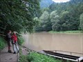 view gallery view gallerySW65 km |  Dunajec river near Szczawnica, Poland Dunajec river near Szczawnica, Poland
in Ferries and Ferry Landings A small ferry across the Dunajec river serves tourists and hikers. posted by: Anneke location: Małopolskie, Poland date approved: 12/13/2009 last visited: 06/22/2019 |
 view gallery view galleryS65.2 km |  Promenade fountain - Bardejov, Slovakia Promenade fountain - Bardejov, Slovakia
in Fountains Beautiful pool shaped fountain, playing tones of music and shining colourfully right next to Bardejov historical city centre. posted by: Rikitan location: Bratislavský kraj, Slovakia date approved: 09/13/2012 last visited: 08/13/2011 |
 view gallery view galleryS65.2 km |  Bardejov Town Conservation Reserve, Slovakia Bardejov Town Conservation Reserve, Slovakia
in World Heritage Sites The fortified town of Bardejov provides exceptionally well-preserved evidence of the economic and social structure of trading towns in medieval Central Europe. posted by: Noe1 location: Prešovský kraj, Slovakia date approved: 06/06/2012 last visited: 05/18/2014 |
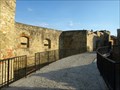 view gallery view galleryS65.3 km |  hradby / city walls - Bardejov, Slovakia hradby / city walls - Bardejov, Slovakia
in Preserved Architectural Remnants and Ruins Unusually well-preserved defensive system from the second half of the 14th century. posted by: Noe1 location: Prešovský kraj, Slovakia date approved: 10/14/2014 last visited: never |
 view gallery view galleryS65.3 km |  Mesto Bardejov - Bardejov, SK Mesto Bardejov - Bardejov, SK
in Coats of Arms CoA of the town on the basilica of St. Egidius. posted by: Noe1 location: Prešovský kraj, Slovakia date approved: 10/21/2014 last visited: never |
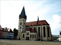
 view gallery view galleryS65.3 km |  Bazilika svatého Jiljí (Bardejov) - Bardejov, SK Bazilika svatého Jiljí (Bardejov) - Bardejov, SK
in Wikipedia Entries Gothic basilica of St. Giles, founded by the Cistercians around the year 1206. posted by: Noe1 location: Prešovský kraj, Slovakia date approved: 10/22/2014 last visited: 09/30/2021 |
 view gallery view galleryS65.3 km |  Bazilika svätého Egídia - Bardejov, SK Bazilika svätého Egídia - Bardejov, SK
in Medieval Churches Gothic basilica of St. Giles, founded by the Cistercians around the year 1206. posted by: Noe1 location: Prešovský kraj, Slovakia date approved: 10/21/2014 last visited: 09/30/2021 |
|