 view gallery view gallery NE4.7 km NE4.7 km
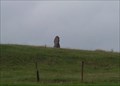
|   Megalith - Luxemburg / Reckange(Mersch) Megalith - Luxemburg / Reckange(Mersch)
in Megalithic Monuments Megalith - Luxemburg / Reckange(Mersch) posted by:  snoopy-doopy snoopy-doopy location: Luxembourg date approved: 08/24/2008 last visited: 08/28/2016 |
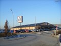 view gallery view galleryNE6.1 km |  Aldi - Mersch, Luxembourg Aldi - Mersch, Luxembourg
in ALDI Stores Aldi store - Z.I. Mierscherbierg Mersch posted by: speedwalkers location: Luxembourg date approved: 01/10/2009 last visited: 02/09/2011 |
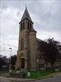
 view gallery view gallery SW10.5 km SW10.5 km
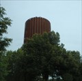
|  Watertower - Kinneksbierg Steinfort, Luxembourg Watertower - Kinneksbierg Steinfort, Luxembourg
in Water Towers Nice watertower on "Kinneksbierg" posted by: speedwalkers location: Luxembourg date approved: 01/27/2009 last visited: 12/08/2013 |
 view gallery view gallery S10.5 km S10.5 km
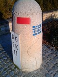
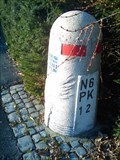
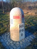
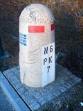
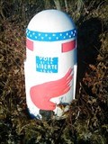
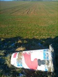
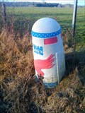
|  Voie de la Liberté - N6 Capellen #2 Voie de la Liberté - N6 Capellen #2
in World War II Memorials / Monuments Liberty Road (French La voie de la Liberté) is the commemorative way marking the route of the Allied forces from D-Day in June 1944. posted by: naj16 location: Luxembourg, Belgium date approved: 03/31/2020 last visited: never |
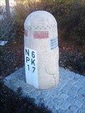
 view gallery view galleryS10.5 km | Voie de la Liberté - N6 Capellen #3 in World War II Memorials / Monuments Liberty Road (French La voie de la Liberté) is the commemorative way marking the route of the Allied forces from D-Day in June 1944. posted by: naj16 location: Luxembourg, Belgium date approved: 03/31/2020 last visited: never |
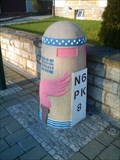
 view gallery view galleryS10.6 km | Voie de la Liberté - N6 Capellen #1 in World War II Memorials / Monuments Liberty Road (French La voie de la Liberté) is the commemorative way marking the route of the Allied forces from D-Day in June 1944. posted by: naj16 location: Luxembourg, Belgium date approved: 03/31/2020 last visited: never |
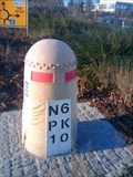
 view gallery view gallerySW10.8 km | Voie de la Liberté - N6 Windhof #1 in World War II Memorials / Monuments Liberty Road (French La voie de la Liberté) is the commemorative way marking the route of the Allied forces from D-Day in June 1944. posted by: naj16 location: Luxembourg, Belgium date approved: 03/31/2020 last visited: never |
 view gallery view gallerySW10.8 km | Voie de la Liberté - N6 Windhof #3 in World War II Memorials / Monuments Liberty Road (French La voie de la Liberté) is the commemorative way marking the route of the Allied forces from D-Day in June 1944. posted by: naj16 location: Luxembourg, Belgium date approved: 03/30/2020 last visited: never |
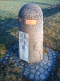 view gallery view gallerySW10.9 km | Voie de la Liberté - N6 Steinfort #1 in World War II Memorials / Monuments Liberty Road (French La voie de la Liberté) is the commemorative way marking the route of the Allied forces from D-Day in June 1944. posted by: naj16 location: Luxembourg, Belgium date approved: 03/30/2020 last visited: never |
 view gallery view gallerySW11.1 km | Voie de la Liberté - N6 Windhof #2 in World War II Memorials / Monuments Liberty Road (French La voie de la Liberté) is the commemorative way marking the route of the Allied forces from D-Day in June 1944. posted by: naj16 location: Luxembourg, Belgium date approved: 03/30/2020 last visited: never |
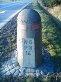
 view gallery view galleryS11.3 km | Voie de la Liberté - N6 Mamer #3 in World War II Memorials / Monuments Liberty Road (French La voie de la Liberté) is the commemorative way marking the route of the Allied forces from D-Day in June 1944. posted by: naj16 location: Luxembourg, Belgium date approved: 04/08/2020 last visited: never |
 view gallery view gallerySW11.6 km | Voie de la Liberté - N6 Steinfort #2 in World War II Memorials / Monuments Liberty Road (French La voie de la Liberté) is the commemorative way marking the route of the Allied forces from D-Day in June 1944. posted by: naj16 location: Luxembourg, Belgium date approved: 03/30/2020 last visited: never |
 view gallery view galleryS11.9 km | Voie de la Liberté - N6 Mamer #2 in World War II Memorials / Monuments Liberty Road (French La voie de la Liberté) is the commemorative way marking the route of the Allied forces from D-Day in June 1944. posted by: naj16 location: Luxembourg, Belgium date approved: 04/08/2020 last visited: never |
 view gallery view gallery SE12.2 km SE12.2 km
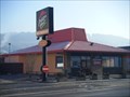
|  Mc Donald's - Bereldange, Luxembourg Mc Donald's - Bereldange, Luxembourg
in McDonald's Restaurants great restaurant posted by: speedwalkers location: Luxembourg date approved: 01/15/2009 last visited: 10/31/2011 |
 view gallery view galleryS12.4 km | Voie de la Liberté - N6 Mamer #1 in World War II Memorials / Monuments Liberty Road (French La voie de la Liberté) is the commemorative way marking the route of the Allied forces from D-Day in June 1944. posted by: naj16 location: Luxembourg, Belgium date approved: 04/08/2020 last visited: never |
 view gallery view gallerySW12.6 km | Voie de la Liberté - N4 Arlon #2 in World War II Memorials / Monuments Liberty Road (French La voie de la Liberté) is the commemorative way marking the route of the Allied forces from D-Day in June 1944. posted by: naj16 location: Luxembourg, Belgium date approved: 03/30/2020 last visited: never |
 view gallery view gallerySE12.7 km |  Pizza Hut - Beggen, Luxembourg Pizza Hut - Beggen, Luxembourg
in Pizza Hut Restaurants Pizza Hut in Beggen Luxembourg posted by: speedwalkers location: Luxembourg date approved: 01/11/2009 last visited: 06/21/2014 |
 view gallery view gallerySW13.2 km | Voie de la Liberté - N4 Arlon #3 in World War II Memorials / Monuments Liberty Road (French La voie de la Liberté) is the commemorative way marking the route of the Allied forces from D-Day in June 1944. posted by: naj16 location: Luxembourg, Belgium date approved: 01/02/2020 last visited: 01/02/2020 |
 view gallery view gallerySW13.7 km |  IGN Pt de mesure: 69E53C1 - Église Sainte-Aldegonde, Sterpenich IGN Pt de mesure: 69E53C1 - Église Sainte-Aldegonde, Sterpenich
in Belgium Benchmarks Elevated IGN mesurement point: 69E53C1 - On top of Sainte-Aldegonde church in Sterpenich, Commune Arlon posted by: kukus location: Luxembourg, Belgium date approved: 08/26/2017 last visited: 10/24/2023 |
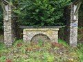 view gallery view gallerySW13.7 km |  Autel pélerinages - Clairefontaine, Arlon, Belgium Autel pélerinages - Clairefontaine, Arlon, Belgium
in Outdoor Altars An Outdoor Altar in the park of ancient Clairefontaine Abbey near Arlon. posted by: kukus location: Luxembourg, Belgium date approved: 08/15/2017 last visited: 03/18/2019 |
 view gallery view gallerySW14.2 km | Voie de la Liberté - N4 Arlon #4 in World War II Memorials / Monuments Liberty Road (French La voie de la Liberté) is the commemorative way marking the route of the Allied forces from D-Day in June 1944. posted by: naj16 location: Luxembourg, Belgium date approved: 01/02/2020 last visited: never |
 NE14.5 km |  Auf Kengert Auf Kengert
in Web Cameras Dieser Webcam Cache befindet sich auf dem Camping „Auf Kengert“ in der Gegend von Medernach.
Ihr könnt an diesen Koordinaten parken: N 49° 11.890 E 006° 48.000
Die Webcam befindet sich an den oben angegebenen Koordinaten. posted by:  .:[B@n]:. .:[B@n]:. location: Luxembourg date approved: 06/26/2007 last visited: 03/23/2012 |
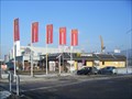
 view gallery view gallerySW14.6 km |  IKEA Arlon - Belgium IKEA Arlon - Belgium
in IKEA This Ikea store is located near the Belgium - Luxembourg border. posted by: rjm1 location: Luxembourg, Belgium date approved: 08/10/2010 last visited: 08/25/2018 |
 view gallery view gallery E15 km E15 km
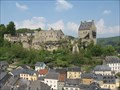
|  Larochette Larochette
in Castles The ruins of Larochette castle are witness of the existence of a huge 11th century fortress. posted by: haxepaxe location: Luxembourg date approved: 05/15/2009 last visited: 05/12/2022 |
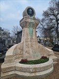 view gallery view gallerySE15.1 km |  Jan-Antoine Zinnen - Cimetière Notre-Dame de Limpertsberg - Luxembourg city, Luxembourg Jan-Antoine Zinnen - Cimetière Notre-Dame de Limpertsberg - Luxembourg city, Luxembourg
in Grave of a Famous Person [EN] Luxembourgian composer, best known for the Luxembourgish national anthem, Ons Hémécht. [FR] Compositeur luxembourgeois, surtout connu pour l'hymne national luxembourgeois, Ons Hémécht. posted by: PaulLassiter location: Luxembourg date approved: 01/29/2024 last visited: never |
|