 view gallery view gallery E3.1 km E3.1 km
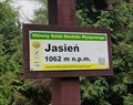
|   1062m - Jasien - Beskid Wyspowy - Malopolskie, Poland 1062m - Jasien - Beskid Wyspowy - Malopolskie, Poland
in Elevation Signs Jasien elevation sign posted by:  sernikk sernikk location: Małopolskie, Poland date approved: 10/28/2021 last visited: never |
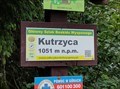 view gallery view galleryE3.2 km | 1051m - Kutrzyca - Beskid Wyspowy - Malopolskie, Poland in Elevation Signs Kutrzyca elevation sign posted by: sernikk location: Małopolskie, Poland date approved: 10/28/2021 last visited: never |
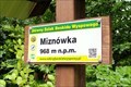 view gallery view galleryE3.2 km | 968m - Miznówka - Beskid Wyspowy - Malopolskie, Poland in Elevation Signs Miznówka elevation sign posted by: sernikk location: Małopolskie, Poland date approved: 10/28/2021 last visited: never |
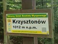 view gallery view galleryE4.2 km | 1012m - Krzysztonów - Beskid Wyspowy - Malopolskie, Poland in Elevation Signs Krzysztonów elevation sign posted by: sernikk location: Małopolskie, Poland date approved: 10/28/2021 last visited: 09/15/2023 |
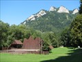
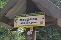 view gallery view galleryE7.1 km | 1170m - Mogielica - Beskid Wyspowy - Malopolskie, Poland in Elevation Signs Mogielica, the highest peak of Beskid Wyspowy posted by: sernikk location: Małopolskie, Poland date approved: 10/28/2021 last visited: 03/15/2024 |
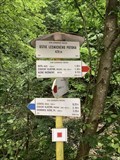
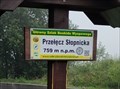 view gallery view galleryE11.6 km | 759m - Przelecz Slopnicka - Beskid Wyspowy - Malopolskie, Poland in Elevation Signs Przelecz Slopnicka elevation sign. posted by: sernikk location: Małopolskie, Poland date approved: 10/28/2021 last visited: 03/15/2024 |
 view gallery view gallery W14 km W14 km
|  Lubon Wielki - Rabka Zdrój, Poland Lubon Wielki - Rabka Zdrój, Poland
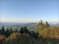
in Scenic Hikes Trail to the Lubon Wielki peak (1022 m) posted by: okrutnyb location: Mazowieckie, Poland date approved: 03/25/2024 last visited: never |
 view gallery view galleryW14 km |  Lubon Wielki Outhouse - Rabka Zdrój, PL Lubon Wielki Outhouse - Rabka Zdrój, PL
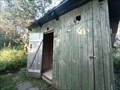
in Outhouses An outhouse at the shelter on Mount Lubon Wielki in the Beskid Wyspowy Mountains. posted by: okrutnyb location: Małopolskie, Poland date approved: 09/30/2023 last visited: never |
 view gallery view gallery SE29.6 km SE29.6 km
|  Trzy Korony, Poland Trzy Korony, Poland
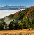
in Mountain Summits The summit of Trzy Korony (982 m above sea level). posted by:  Anneke Anneke location: Małopolskie, Poland date approved: 12/12/2009 last visited: 06/21/2019 |
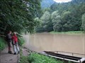 view gallery view gallerySE30.9 km |  Dunajec river near Szczawnica, Poland Dunajec river near Szczawnica, Poland
in Ferries and Ferry Landings A small ferry across the Dunajec river serves tourists and hikers. posted by: Anneke location: Małopolskie, Poland date approved: 12/13/2009 last visited: 06/22/2019 |
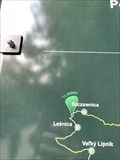 view gallery view gallerySE30.9 km |  "You are here" Szczawnica, Poland "You are here" Szczawnica, Poland
in 'You Are Here' Maps A ¨You Are Here¨ cycling route map. posted by: davidb11 location: Małopolskie, Poland date approved: 02/20/2020 last visited: never |
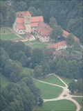 view gallery view gallerySE31.1 km |  Cerveny klastor, Slovakia Cerveny klastor, Slovakia
in Abbeys, Convents and Monasteries Cervený kláštor (The Red Monastery), located near the Polish border, served first as a Carthusian, then as Camaldolese monastery. It gained its name from the red roof cover after a reconstruction in the 18th century. posted by: Anneke location: Prešovský kraj, Slovakia date approved: 12/25/2009 last visited: 06/21/2019 |
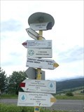
 view gallery view gallerySE31.1 km |  ÚSTIE LESNICKÉHO POTOKA, 429 m, Slovakia ÚSTIE LESNICKÉHO POTOKA, 429 m, Slovakia
in Direction and Distance Arrows Turistický rozcestník pri ústí Lesnického potoka do Dunajce.
Turist direction and distance arrows at the mouth of Lesnický brook to Dunajec. posted by: davidb11 location: Prešovský kraj, Slovakia date approved: 07/01/2019 last visited: never |
 view gallery view gallerySE31.1 km |  Naucná stezka Prielom Dunajca, Pieniny, Slovakia Naucná stezka Prielom Dunajca, Pieniny, Slovakia
in Self Guided Walks and Trails Naucná stezka Prielom Dunajca,Pieniny. Self Guides Prielom Dunajca,Pieniny. posted by: davidb11 location: Prešovský kraj, Slovakia date approved: 01/13/2020 last visited: never |
 view gallery view gallerySE31.1 km |  Cervený kláštor - Lesnica, Slovakia Cervený kláštor - Lesnica, Slovakia
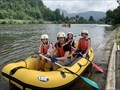
in Canoe/Kayak Trips Zacátek splutí Dunajce pres Pieniny.
Beginning of the Dunajec River via Pieniny. posted by: davidb11 location: Prešovský kraj, Slovakia date approved: 07/22/2019 last visited: never |
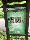
 view gallery view gallerySE34 km | Haligovské skaly - Pieniny, Slovakia in Scenic Hikes Explore mystic world of limestone towers and cavities in Haligovské skaly at far north of Slovakia. Not difficult, half-day long hike will lead you into the middle of their natural beauties. Best tip for photographers. posted by: Rikitan location: Prešovský kraj, Slovakia date approved: 10/26/2014 last visited: never |
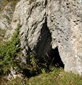 view gallery view gallerySE34.4 km | ") Zbojnícka jaskyna - Pieniny, Slovakia Zbojnícka jaskyna - Pieniny, Slovakia
in Cave Entrances (Natural) Zbojnícka jaskyna (Outlaw’s cave) is approx. 30 metres long cave in limestone rock, hidden on southern slopes of Haligovské skaly (Haligovce Rocks) under Hrubá skala (the Rough Rock). Locality belongs to Pieniny National Park. posted by: Rikitan location: Prešovský kraj, Slovakia date approved: 10/26/2014 last visited: never |
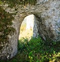 view gallery view gallerySE34.4 km | Zbojnícka Brána - Pieniny, Slovakia in Natural Arches Zbojnícka Brána (Outlaw’s Gate) is 5 metres high limestone rock window, hidden on southern slopes of Haligovce Rocks that belong to Pieniny National Park. Along with a cave in front of the Gate, it belongs to Park’s most interesting natural beauties. posted by: Rikitan location: Prešovský kraj, Slovakia date approved: 10/26/2014 last visited: never |
 view gallery view gallerySE35.7 km | LESNICKÉ SEDLO, 720 m, Slovakia in Direction and Distance Arrows Turistický rozcestník v Lesnickém sedle.
Tourist signpost in the Lesnica saddle. posted by: davidb11 location: Prešovský kraj, Slovakia date approved: 07/01/2019 last visited: never |
 view gallery view gallery N39.9 km N39.9 km
|  Pilgrims’ Route (Wieliczka Salt Mine) - Wieliczka, Polska Pilgrims’ Route (Wieliczka Salt Mine) - Wieliczka, Polska
in Grand Opening The Pilgrims’ Route in the “Wieliczka” Salt Mine posted by: puczmeloun location: Małopolskie, Poland date approved: 11/21/2013 last visited: 12/23/2019 |
 view gallery view galleryN39.9 km |  Nicolaus Copernicus (Wieliczka Salt Mine) - Wieliczka, Polska Nicolaus Copernicus (Wieliczka Salt Mine) - Wieliczka, Polska
in Statues of Historic Figures Statue of Nicolaus Copernicus in Wieliczka Salt Mine posted by: puczmeloun location: Małopolskie, Poland date approved: 11/21/2013 last visited: 12/26/2019 |
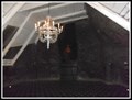
 view gallery view galleryN39.9 km |  Chapel of St. Kinga (Wieliczka Salt Mine) - Wieliczka, Polska Chapel of St. Kinga (Wieliczka Salt Mine) - Wieliczka, Polska
in Roman Catholic Churches The Chapel of St. Kinga in "Wieliczka" Salt Mine posted by: puczmeloun location: Małopolskie, Poland date approved: 11/21/2013 last visited: 12/23/2019 |
 view gallery view galleryN39.9 km |  Chapel of the Holy Cross (Wieliczka Salt Mine) - Wieliczka, Polska Chapel of the Holy Cross (Wieliczka Salt Mine) - Wieliczka, Polska
in Waychapels The Chapel of the Holy Cross posted by: puczmeloun location: Małopolskie, Poland date approved: 11/21/2013 last visited: 12/26/2019 |
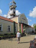 view gallery view galleryN39.9 km |  Wieliczka Salt Mine Wieliczka Salt Mine
in Salt Pans and Mines This UNESCO World Heritage site, the Wieliczka Salt Mine is located a short bus ride from Krakow,Poland in the town of Wieleczka. posted by: Skyecat location: Małopolskie, Poland date approved: 10/27/2021 last visited: 07/16/2021 |
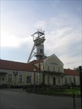 view gallery view galleryN39.9 km |  Wieliczka Salt Mines- Poland Wieliczka Salt Mines- Poland
in World Heritage Sites This is the most amazing place with caverns, a Church with some lovely carvings all in salt, a restaurant and even a lake with a boat on it. posted by: Norfolk12 location: Małopolskie, Poland date approved: 03/24/2008 last visited: 07/16/2021 |
|