 view gallery view gallery NE16.9 km NE16.9 km
|   Bell tower / Kath. Pfarrkirche Eslarn - BY - GER Bell tower / Kath. Pfarrkirche Eslarn - BY - GER
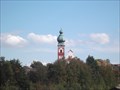
in Bell Towers Der fast 50 Meter hohe Glockenturm der katholischen Kirche in Eslarn/
The almost 50 meter high bell tower of the Catholic Church in Eslarn posted by:  *Team Krombaer* *Team Krombaer* location: Bayern, Germany date approved: 10/06/2012 last visited: never |
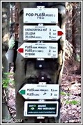 view gallery view galleryNE18.2 km |  710m - Pod Pleší(rozc.), Belá nad Radbuzou, CZ 710m - Pod Pleší(rozc.), Belá nad Radbuzou, CZ
in Elevation Signs Výška uvedená na rozcestníku "Pod Pleší(rozc.)"
EN/Elevation Sign on crossroads "Pod Pleší(rozc.)" posted by: Blogi location: Plzeňský kraj, Czechia date approved: 06/24/2019 last visited: never |
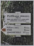 view gallery view galleryNE18.5 km | 700m - Pleš(nám.prírody), Belá nad Radbuzou, CZ in Elevation Signs Výška uvedená na rozcestníku "Pleš(nám.prírody)"
EN/Elevation Sign on crossroads "Pleš(nám.prírody)" posted by: Blogi location: Plzeňský kraj, Czechia date approved: 06/24/2019 last visited: never |
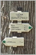 view gallery view galleryNE18.5 km | 650m - Lucina, Nemanice, CZ in Elevation Signs Výška uvedená na rozcestníku "Lucina"
EN/Elevation Sign on crossroads "Lucina" posted by: Blogi location: Plzeňský kraj, Czechia date approved: 06/24/2019 last visited: never |
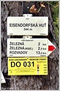 view gallery view galleryNE19.2 km | 544m - Eisendorfská Hut, Belá nad Radbuzou, CZ in Elevation Signs Výška uvedená na rozcestníku "Eisendorfská Hut"
EN/Elevation Sign on crossroads "Eisendorfská Hut" posted by: Blogi location: Plzeňský kraj, Czechia date approved: 06/24/2019 last visited: never |
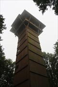 view gallery view gallery E19.3 km E19.3 km
|  Böhmerwaldturm Böhmerwaldturm
in Look-Out Towers Ein im Jahre 1983 gebauter Aussichtsturm mit Blick auf den Oberpfälzer- und Böhmerwald.
Look-Out Tower built in 1983 with a view of the Oberpfälzerwald and Böhmerwald. posted by: Kon1 location: Bayern, Germany date approved: 09/23/2021 last visited: never |
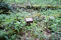 view gallery view galleryE19.8 km |  TB 1914-34 U Dianina Dvora, Rybník (DO) TB 1914-34 U Dianina Dvora, Rybník (DO)
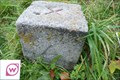
in Czech Geodetic Points TB 1914-34.0 je na nejvyšším bodu, je 800 m na severovýchod od Dianina Dvora. posted by:  torfik torfik location: Plzeňský kraj, Czechia date approved: 08/20/2013 last visited: 08/19/2018 |
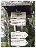
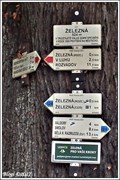 view gallery view galleryNE20.3 km |  Rozcestník turistických tras - Železná, Belá nad Radbuzou, CZ Rozcestník turistických tras - Železná, Belá nad Radbuzou, CZ
in Direction and Distance Arrows Rozcestník turistických tras "Železná"
EN/Distance Arrows of tourist trails "Železná" posted by: Blogi location: Plzeňský kraj, Czechia date approved: 07/22/2019 last visited: never |
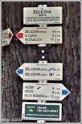 view gallery view galleryNE20.3 km | 524m - Železná, Belá nad Radbuzou, CZ in Elevation Signs Výška uvedená na rozcestníku "Železná"
EN/Elevation Sign on crossroads "Železná" posted by: Blogi location: Plzeňský kraj, Czechia date approved: 06/24/2019 last visited: never |
 view gallery view gallery N20.9 km N20.9 km
|  Clocks on church of Heiligkreuz - Pleystein, BY, Germany Clocks on church of Heiligkreuz - Pleystein, BY, Germany
in Town Clocks Clocks on the tower of the church of Heiligkreuz in Pleystein. posted by: Noe1 location: Bayern, Germany date approved: 05/02/2015 last visited: 05/17/2022 |
 view gallery view galleryE21.4 km | TB 1914-31 U bažin, Rybník (DO) in Czech Geodetic Points TB 1914-31.0 je v cípu vysokého lesa nad obcí Rybník. posted by: torfik location: Plzeňský kraj, Czechia date approved: 08/20/2013 last visited: never |
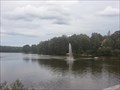 view gallery view gallery S21.4 km S21.4 km
|  Jet dèau in Bodenwöhr/ Bayern/ Deutschland Jet dèau in Bodenwöhr/ Bayern/ Deutschland
in Fountains This giant fountain gushing from the south end of lake Hammerweiher is the symbol of the town Bodenwöhr, Germany. posted by: *Team Krombaer* location: Bayern, Germany date approved: 09/12/2014 last visited: 03/14/2016 |
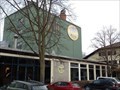 view gallery view galleryS21.7 km |  Brauerei Jacob - Bodenwöhr, Opf / Deutschland Brauerei Jacob - Bodenwöhr, Opf / Deutschland
in Breweries [D] Privatbrauerei Jacob am Hammersee in Bodenwöhr, Deutschland.
[EN] Private brewery in Upper Palatinate, Germany. posted by: *Team Krombaer* location: Bayern, Germany date approved: 01/08/2022 last visited: 06/10/2022 |
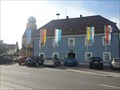 view gallery view galleryS21.7 km |  Halt' die Fahne in den Wind... - Rathaus Bodenwöhr/ Deutschland Halt' die Fahne in den Wind... - Rathaus Bodenwöhr/ Deutschland
in Municipal Flags In front of the townhall in Bodenwöhr, Germany, Bayern stand some flags - one of them is the municipal flag of Bodenwöhr. posted by: *Team Krombaer* location: Bayern, Germany date approved: 09/13/2014 last visited: 03/14/2016 |
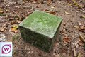
 view gallery view galleryE21.9 km | BTP 3078.01 Rybník in Czech Geodetic Points Bod základního tíhového bodového pole 3078.01 Rybník.
Bod je stabilizován betonovou deskou s hrebovou nivelacní znackou uprostred.
Bod leží na okraji živého plotu u cp. 8 v obci Rybník. Ochranná tyc je zarostlá a není skoro videt posted by: rsc_cz location: Plzeňský kraj, Czechia date approved: 02/12/2021 last visited: never |
 view gallery view galleryNE22.9 km | 498m - Rybnicná, Rozvadov, CZ in Elevation Signs Výška uvedená na rozcestníku "Rybnicná"
EN/Elevation Sign on crossroads "Rybnicná" posted by: Blogi location: Plzeňský kraj, Czechia date approved: 06/24/2019 last visited: never |
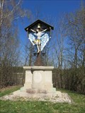 view gallery view gallery SW23.3 km SW23.3 km
|  Wackersdorfer Grubenkreuz - Wackendorf, BY, Germany Wackersdorfer Grubenkreuz - Wackendorf, BY, Germany
in Christian Crosses The cross is located on the little hillock near the entry to the brown coal mine in Wackendorf. posted by: virtual.franken location: Bayern, Germany date approved: 04/20/2015 last visited: 03/14/2016 |
 view gallery view gallerySW23.3 km |  Verwaltungsgebäude BBI near Wackersdorf Verwaltungsgebäude BBI near Wackersdorf
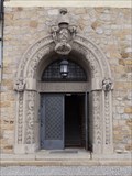
in Doorways of the World --- engl.--- This unique doorway can be found on the old "Verwaltungsgebäude" of the former BBI near Wackersdorf --- german --- Diese einzigartige Türe befindet sich am alten "Verwaltungsgebäude" der früheren BBI bei Wackersdorf posted by: Windego1 location: Bayern, Germany date approved: 09/04/2013 last visited: 03/14/2016 |
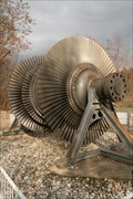 view gallery view gallerySW23.3 km |  Dampfturbinenläufer - Wackersdorf, Lk. Schwandorf, Bayern, D Dampfturbinenläufer - Wackersdorf, Lk. Schwandorf, Bayern, D
in Preserved Machines on Public Display Ein Niederdruck-Turbinenläufer in Wackersdorf. posted by: Tharandter location: Bayern, Germany date approved: 05/22/2013 last visited: 09/12/2024 |
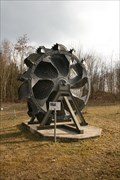 view gallery view gallerySW23.3 km | Schaufelrad - Wackersdorf, Lk. Schwandorf, Bayern, D in Preserved Machines on Public Display Schaufelrad eines Schaufelradbaggers. posted by: Tharandter location: Bayern, Germany date approved: 05/23/2013 last visited: 03/14/2016 |
 view gallery view galleryE23.5 km | TB 1914-36 Tamaryskuv haj in Czech Geodetic Points Trigonometrický bod v Ceském lese posted by: pavlikVB location: Plzeňský kraj, Czechia date approved: 10/02/2012 last visited: never |
 view gallery view galleryE23.8 km | TB 1915-11 Herstejn in Czech Geodetic Points Trigonometrický bod v Ceském lese posted by: pavlikVB location: Plzeňský kraj, Czechia date approved: 10/02/2012 last visited: never |
 view gallery view gallery W24.1 km W24.1 km
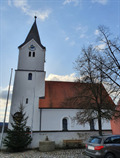
|  Sankt Nikolaus-Kirche - Trisching, BY, Germany Sankt Nikolaus-Kirche - Trisching, BY, Germany
in This Old Church Sankt Nikolaus-Kirche in Trisching - St. Nicholas Church in Trisching posted by: pruppi location: Bayern, Germany date approved: 01/20/2020 last visited: 02/08/2020 |
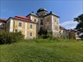 view gallery view galleryNE24.3 km |  Diana - West Bohemia, Czech Republic Diana - West Bohemia, Czech Republic
in Castles Diana - hunting-seat (castle) posted by: ToRo61 location: Plzeňský kraj, Czechia date approved: 10/29/2016 last visited: never |
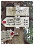 view gallery view galleryNE24.6 km | 525m - Smrcina, Rozvadov, CZ in Elevation Signs Výška uvedená na rozcestníku "Smrcina"
EN/Elevation Sign on crossroads "Smrcina" posted by: Blogi location: Plzeňský kraj, Czechia date approved: 06/15/2019 last visited: never |
|