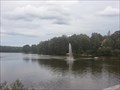
 view gallery view gallery SW13.2 km SW13.2 km
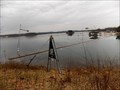
|   Jet dèau in Bodenwöhr/ Bayern/ Deutschland Jet dèau in Bodenwöhr/ Bayern/ Deutschland
in Fountains This giant fountain gushing from the south end of lake Hammerweiher is the symbol of the town Bodenwöhr, Germany. posted by:  *Team Krombaer* *Team Krombaer* location: Bayern, Germany date approved: 09/12/2014 last visited: 03/14/2016 |
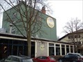 view gallery view gallerySW13.4 km |  Brauerei Jacob - Bodenwöhr, Opf / Deutschland Brauerei Jacob - Bodenwöhr, Opf / Deutschland
in Breweries [D] Privatbrauerei Jacob am Hammersee in Bodenwöhr, Deutschland.
[EN] Private brewery in Upper Palatinate, Germany. posted by: *Team Krombaer* location: Bayern, Germany date approved: 01/08/2022 last visited: 06/10/2022 |
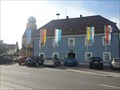 view gallery view gallerySW13.5 km |  Halt' die Fahne in den Wind... - Rathaus Bodenwöhr/ Deutschland Halt' die Fahne in den Wind... - Rathaus Bodenwöhr/ Deutschland
in Municipal Flags In front of the townhall in Bodenwöhr, Germany, Bayern stand some flags - one of them is the municipal flag of Bodenwöhr. posted by: *Team Krombaer* location: Bayern, Germany date approved: 09/13/2014 last visited: 03/14/2016 |
 view gallery view gallery SE16.4 km SE16.4 km
|  Kloster Strahlfeld - Roding, Bayern, Gemany Kloster Strahlfeld - Roding, Bayern, Gemany
in Wikipedia Entries Kloster St. Dominikus in Strahlfeld
***
Kloster St. Dominikus in Strahlfeld - Bavaria. posted by: Tintenklexx location: Bayern, Germany date approved: 03/25/2018 last visited: never |
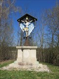 view gallery view gallerySW18.2 km |  Wackersdorfer Grubenkreuz - Wackendorf, BY, Germany Wackersdorfer Grubenkreuz - Wackendorf, BY, Germany
in Christian Crosses The cross is located on the little hillock near the entry to the brown coal mine in Wackendorf. posted by:  virtual.franken virtual.franken location: Bayern, Germany date approved: 04/20/2015 last visited: 03/14/2016 |
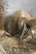 view gallery view gallerySW18.2 km |  Dampfturbinenläufer - Wackersdorf, Lk. Schwandorf, Bayern, D Dampfturbinenläufer - Wackersdorf, Lk. Schwandorf, Bayern, D
in Preserved Machines on Public Display Ein Niederdruck-Turbinenläufer in Wackersdorf. posted by: Tharandter location: Bayern, Germany date approved: 05/22/2013 last visited: 03/14/2016 |
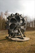 view gallery view gallerySW18.2 km | Schaufelrad - Wackersdorf, Lk. Schwandorf, Bayern, D in Preserved Machines on Public Display Schaufelrad eines Schaufelradbaggers. posted by: Tharandter location: Bayern, Germany date approved: 05/23/2013 last visited: 03/14/2016 |
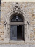 view gallery view gallerySW18.3 km |  Verwaltungsgebäude BBI near Wackersdorf Verwaltungsgebäude BBI near Wackersdorf
in Doorways of the World --- engl.--- This unique doorway can be found on the old "Verwaltungsgebäude" of the former BBI near Wackersdorf --- german --- Diese einzigartige Türe befindet sich am alten "Verwaltungsgebäude" der früheren BBI bei Wackersdorf posted by: Windego1 location: Bayern, Germany date approved: 09/04/2013 last visited: 03/14/2016 |
 view gallery view gallerySW19.5 km |  Rescue Station Stainberg - Steinberger See, Bayern, DE Rescue Station Stainberg - Steinberger See, Bayern, DE
in Lifeboats and Rescue Stations Rescue Station Stainberg (Wasserwacht Ortsgruppe Steinberg) on the Steinberger See. posted by: Noe1 location: Bayern, Germany date approved: 03/29/2015 last visited: 04/19/2015 |
 view gallery view gallerySW19.8 km |  Wild Wake & Ski - Steinberger See, Bayern, Germany Wild Wake & Ski - Steinberger See, Bayern, Germany
in Cable Skiing and Wakeboarding Two cableway tracks on Steinberger See, Germany. posted by: Noe1 location: Bayern, Germany date approved: 03/28/2015 last visited: 04/19/2015 |
 view gallery view gallerySW20.9 km | Died so young - Alexander Faderl - Steinberger See, BY, Germany in Christian Crosses This wooden cross is located directly on the coast of Steinberger See. It's commemorating the death of Alexander Faderl, the diver, who have died in the age of 40. posted by: Mike_bjm location: Bayern, Germany date approved: 08/09/2018 last visited: never |
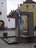 view gallery view gallerySW21.7 km | Torbrunnen in Nittenau/Oberpfalz in Fountains --- engl. --- nice and modern "Torbrunnen"-fountain in Nittenau at the market place --- german --- am Marktplatz in Nittenau findet sich der schöne und moderne "Torbrunnen" posted by: Windego1 location: Bayern, Germany date approved: 09/05/2013 last visited: never |
 view gallery view gallerySW21.7 km |  Marktplatz Nittenau N 49° 11' 55.87" u. E 012° 16' 23.74 Marktplatz Nittenau N 49° 11' 55.87" u. E 012° 16' 23.74
in Permanent Geographic Coordinates --- engl. --- Geocoordinates of Nittenau shown beside the "Torbrunnen" at Nittenau market place --- german --- Die Geokoordinaten von Nittenau werden neben dem "Torbrunnen" von Nittenau am Marktplatz gezeigt. posted by: Windego1 location: Bayern, Germany date approved: 09/05/2013 last visited: never |
 view gallery view gallery W22 km W22 km
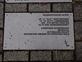
|  Karolina, Frieda, Louis and Selma Waldmann Karolina, Frieda, Louis and Selma Waldmann
in Stolpersteine This Stolperstein is commemorating Karolina, Frieda, Louis and Selma Waldmann. posted by: virtual.franken location: Bayern, Germany date approved: 04/19/2015 last visited: 01/07/2022 |
 view gallery view gallery NE22.9 km NE22.9 km
|  TB 1914-34 U Dianina Dvora, Rybník (DO) TB 1914-34 U Dianina Dvora, Rybník (DO)
in Czech Geodetic Points TB 1914-34.0 je na nejvyšším bodu, je 800 m na severovýchod od Dianina Dvora. posted by: torfik location: Plzeňský kraj, Czechia date approved: 08/20/2013 last visited: 08/19/2018 |
 view gallery view gallery S22.9 km S22.9 km
|  Trafotower at the outskirt of Roding - BY / Germany Trafotower at the outskirt of Roding - BY / Germany
in Historic Transformer Sub-Stations Buildings Simple, plastered trafotower off the villages posted by: Iris & Harry location: Bayern, Germany date approved: 11/09/2016 last visited: never |
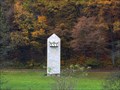
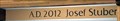 view gallery view galleryS23 km |  2012 - Chapel near Angstall, Zell - BY / Germany 2012 - Chapel near Angstall, Zell - BY / Germany
in Dated Buildings and Cornerstones Modern Chapel, AD 2012 Josef Stuber posted by: Iris & Harry location: Bayern, Germany date approved: 11/20/2016 last visited: never |
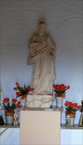
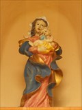 view gallery view galleryS23 km |  Virgin Mary with infant Jesus at Chapel near Angstall, Zell - BY / Germany Virgin Mary with infant Jesus at Chapel near Angstall, Zell - BY / Germany
in Statues of Religious Figures Statue in a niche at the chapel. posted by: Iris & Harry location: Bayern, Germany date approved: 11/12/2016 last visited: never |
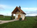 view gallery view galleryS23 km |  Chapel near Angstall, Zell - BY / Germany Chapel near Angstall, Zell - BY / Germany
in Waychapels Modern Chapel, AD 2012 Josef Stuber posted by: Iris & Harry location: Bayern, Germany date approved: 11/12/2016 last visited: never |
 view gallery view galleryS23 km | St. Joseph in the Chapel near Angstall, Zell - BY / Germany in Statues of Religious Figures Detailed St. Joseph Statue inside the Chapel posted by: Iris & Harry location: Bayern, Germany date approved: 11/12/2016 last visited: never |
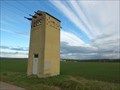 view gallery view galleryS23.3 km | Trafotower near Zell - BY / Germany in Historic Transformer Sub-Stations Buildings Plastered yellow colored Trafotower near the road. posted by: Iris & Harry location: Bayern, Germany date approved: 11/09/2016 last visited: never |
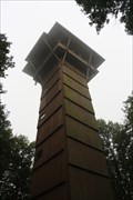 view gallery view galleryNE23.7 km |  Böhmerwaldturm Böhmerwaldturm
in Look-Out Towers Ein im Jahre 1983 gebauter Aussichtsturm mit Blick auf den Oberpfälzer- und Böhmerwald.
Look-Out Tower built in 1983 with a view of the Oberpfälzerwald and Böhmerwald. posted by: Kon1 location: Bayern, Germany date approved: 09/23/2021 last visited: never |
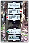 view gallery view galleryNE24 km |  710m - Pod Pleší(rozc.), Belá nad Radbuzou, CZ 710m - Pod Pleší(rozc.), Belá nad Radbuzou, CZ
in Elevation Signs Výška uvedená na rozcestníku "Pod Pleší(rozc.)"
EN/Elevation Sign on crossroads "Pod Pleší(rozc.)" posted by: Blogi location: Plzeňský kraj, Czechia date approved: 06/24/2019 last visited: never |
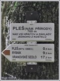 view gallery view galleryNE24.1 km | 700m - Pleš(nám.prírody), Belá nad Radbuzou, CZ in Elevation Signs Výška uvedená na rozcestníku "Pleš(nám.prírody)"
EN/Elevation Sign on crossroads "Pleš(nám.prírody)" posted by: Blogi location: Plzeňský kraj, Czechia date approved: 06/24/2019 last visited: never |
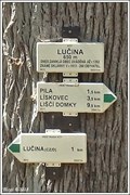 view gallery view galleryNE24.1 km | 650m - Lucina, Nemanice, CZ in Elevation Signs Výška uvedená na rozcestníku "Lucina"
EN/Elevation Sign on crossroads "Lucina" posted by: Blogi location: Plzeňský kraj, Czechia date approved: 06/24/2019 last visited: never |
|