 view gallery view gallery SW43.8 km SW43.8 km
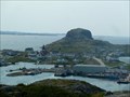
|   Dover Hilltop Dover Hilltop
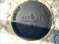
in Canadian Benchmarks Found near the Dover Fault Observation Deck. posted by:  GOTNL GOTNL location: Newfoundland and Labrador, Canada date approved: 10/18/2014 last visited: 09/23/2018 |
 view gallery view gallery S55.8 km S55.8 km
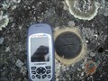
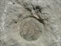
| BM 90F037 approximately 3 Km SW of Salvage Newfoundland and Labrador in Canadian Benchmarks Canada Geodetic Survey marker Southwest of Salvage NL posted by: YQX52 location: Newfoundland and Labrador, Canada date approved: 05/22/2012 last visited: never |
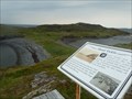
 view gallery view gallerySW56.2 km | Benchmark in Canadian Benchmarks On main HGYW between Gambo @ Hare Bay posted by: heyou location: Newfoundland and Labrador, Canada date approved: 07/16/2007 last visited: 06/25/2009 |
 view gallery view gallery SE62.1 km SE62.1 km
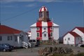
|  Cape Bonavista Lighthouse, Newfoundland, Canada Cape Bonavista Lighthouse, Newfoundland, Canada
in Coastal Lighthouses Sits on the northmost point of the Bonavista Peninsula in Newfoundland. posted by:  Team Polarbear Team Polarbear location: Newfoundland and Labrador, Canada date approved: 07/14/2007 last visited: 08/06/2017 |
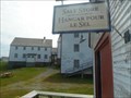
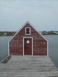
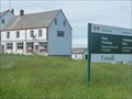 view gallery view gallerySE66 km |  CNHS - The East Coast Fishery and the Ryan Premises - Bonavista, Newfoundland and Labrador CNHS - The East Coast Fishery and the Ryan Premises - Bonavista, Newfoundland and Labrador
in Canadian National Historic Sites Ryan Premises National Historic Site was established in 1997, 500 years after the landing of John Cabot in Bonavista. It consists of a number of museum buildings which describe and animate the importance of the fishery and sealing industries. posted by: Trail Blaisers location: Newfoundland and Labrador, Canada date approved: 08/03/2015 last visited: 06/09/2018 |
 view gallery view gallerySE66 km |  Ryan Premises National Historic Site - Bonavista, Newfoundland and Labrador Ryan Premises National Historic Site - Bonavista, Newfoundland and Labrador
in Maritime Museums Ryan Premises National Historic Site was established in 1997, 500 years after the landing of John Cabot in Bonavista. It consists of a number of museum buildings which describe and animate the importance of the fishery and sealing industries. posted by: Trail Blaisers location: Newfoundland and Labrador, Canada date approved: 01/14/2019 last visited: never |
 view gallery view gallery NW70 km NW70 km
| CNHS - Tilting Cultural Landscape - Fogo Island, Newfoundland and Labrador in Canadian National Historic Sites Tilting is a living cultural landscape that encompasses natural and built places that together depict traditional outport life. posted by: Trail Blaisers location: Newfoundland and Labrador, Canada date approved: 08/03/2015 last visited: never |
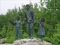
 view gallery view gallerySE70.3 km |  The Sealers Memorial - Elliston, Newfoundland and Labrador The Sealers Memorial - Elliston, Newfoundland and Labrador
in Occupational Monuments The Sealers Memorial is a tribute to the 251 men who lost their lives in two separate disasters during a 1914 storm. The bronze sculpture is sorrowful - of a father and son holding one another as they brave the elements with little hope of survival. posted by: Trail Blaisers location: Newfoundland and Labrador, Canada date approved: 08/18/2015 last visited: 06/09/2018 |
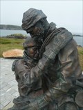 view gallery view gallerySE70.3 km |  Home from The Sea Sealers Memorial - Elliston, Newfoundland and Labrador Home from The Sea Sealers Memorial - Elliston, Newfoundland and Labrador
in Maritime Monuments and Memorials The Sealers Memorial is a tribute to the 251 men who lost their lives in two separate disasters during a 1914 storm. The bronze sculpture is sorrowful - of a father and son holding one another as they brave the elements with little hope of survival. posted by: Trail Blaisers location: Newfoundland and Labrador, Canada date approved: 08/18/2015 last visited: 06/09/2018 |
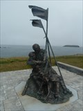 view gallery view gallerySE70.3 km |  Unveiling of The Sealers Memorial - Elliston, Newfoundland and Labrador Unveiling of The Sealers Memorial - Elliston, Newfoundland and Labrador
in News Article Locations On June 20, 2014, CBC carried a story about the unveiling of The Sealers Memorial in Elliston. It is a tribute to the 251 men who lost their lives in two separate disasters during a 1914 storm. posted by: Trail Blaisers location: Newfoundland and Labrador, Canada date approved: 08/19/2015 last visited: 06/09/2018 |
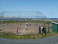 view gallery view galleryNW76.8 km |  Softball Diamond - Joe Batt's Arm South, Newfoundland and Labrador Softball Diamond - Joe Batt's Arm South, Newfoundland and Labrador
in Amateur Baseball Fields There are some picturesque settings for playing ball, but this has to be up there. Looking out over Joe Batt's Arm and the North Atlantic. On "Iceberg Alley", it's not uncommon this time of year to have an iceberg float by during the game. posted by: Trail Blaisers location: Newfoundland and Labrador, Canada date approved: 07/23/2015 last visited: never |
 view gallery view gallery W78.4 km W78.4 km
|  Gander International Airport - Gander, Newfoundland and Labrador, Canada Gander International Airport - Gander, Newfoundland and Labrador, Canada
in Airports Gander International's heyday was in the 1940s to 1950s when it was a frequent stopover for planes needing to refuel between Europe and North America. It was also a major training ground during WWII. posted by: Trail Blaisers location: Newfoundland and Labrador, Canada date approved: 07/19/2015 last visited: never |
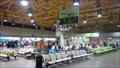 view gallery view galleryW78.5 km |  Inside Gander International Airport - Gander, Newfoundland and Labrador Inside Gander International Airport - Gander, Newfoundland and Labrador
in Inside Airports Gander was once one of the busiest layover locations in the world when flights between North America and Europe needed to refuel here. Today, connections will get you to locations around the province and Maritimes. posted by: Trail Blaisers location: Newfoundland and Labrador, Canada date approved: 07/19/2015 last visited: never |
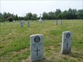 view gallery view galleryW78.9 km |  Commonwealth War Graves - Gander, Newfoundland and Labrador Commonwealth War Graves - Gander, Newfoundland and Labrador
in Veteran Cemeteries Gander was the most important launching point for Europe-bound Allied aircraft during WWII. Unfortunately, many airmen and soldiers lost their lives here during training or other accidents. 100 are buried here. posted by: Trail Blaisers location: Newfoundland and Labrador, Canada date approved: 08/17/2015 last visited: never |
 view gallery view galleryW78.9 km |  Canadian Forces Base (9 Wing) Gander - Gander, Newfoundland and Labrador Canadian Forces Base (9 Wing) Gander - Gander, Newfoundland and Labrador
in Military Installations 9 Wing Gander was established in 1935. Once Canada went to war in 1939 it grew in importance. At one point, Winston Churchill referred to it as "the largest aircraft carrier in the North Atlantic". posted by: Trail Blaisers location: Newfoundland and Labrador, Canada date approved: 07/21/2019 last visited: never |
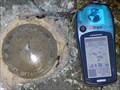 view gallery view galleryW78.9 km | Geodetic Survey Gander 90F149 in Canadian Benchmarks Brass survey disk located near CFB Gander. posted by: GOTNL location: Newfoundland and Labrador, Canada date approved: 10/02/2006 last visited: 07/01/2007 |
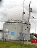 view gallery view galleryW79 km |  Weather Radar - Gander, Newfoundland and Labrador Weather Radar - Gander, Newfoundland and Labrador
in Weather Radars This weather radar has been operational at Canadian Forces Base Gander since the summer of 1940. Gander was the most important launching point for Allied airplanes heading to/from Europe during WWII. posted by: Trail Blaisers location: Newfoundland and Labrador, Canada date approved: 07/21/2019 last visited: never |
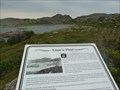 view gallery view galleryNW79.3 km |  Lion's Den (Ghost Town) - Fogo, Newfoundland and Labrador Lion's Den (Ghost Town) - Fogo, Newfoundland and Labrador
in Ghost Towns Lion's Den is one of four abandoned communities around the Town of Fogo on Fogo Island. Absolutely nothing remains - all buildings were moved by boat or floated to other communities. posted by: Trail Blaisers location: Newfoundland and Labrador, Canada date approved: 07/24/2015 last visited: never |
 view gallery view galleryNW79.5 km |  Fogo, Newfoundland and Labrador - Population 982 Fogo, Newfoundland and Labrador - Population 982
in Population Signs The town of Fogo is found on Fogo Island which sticks out from Newfoundland into the North Atlantic Ocean. posted by: Trail Blaisers location: Newfoundland and Labrador, Canada date approved: 08/24/2017 last visited: never |
 view gallery view galleryW79.7 km |  Arrow Air Flight MF1285R Arrow Air Flight MF1285R
in Plane Crash Sites The Arrow Air crash was the worst air disaster ever on Canadian soil. posted by: wilsonjw location: Newfoundland and Labrador, Canada date approved: 08/24/2005 last visited: 10/25/2022 |
 view gallery view galleryW80 km | Geodetic Survey Gander 76G0253 in Canadian Benchmarks Benchmark Disk set in stone near Gander, NL. posted by: GOTNL location: Newfoundland and Labrador, Canada date approved: 10/02/2006 last visited: 07/09/2011 |
 view gallery view galleryNW80.1 km |  View of Fogo from East of Town - Fogo, Newfoundland and Labrador View of Fogo from East of Town - Fogo, Newfoundland and Labrador
in Cityscapes A dramatic spot to take in the town and its surroundings. posted by: Trail Blaisers location: Newfoundland and Labrador, Canada date approved: 08/23/2017 last visited: never |
 view gallery view galleryNW80.3 km |  Shoal Tickle - Fogo, Newfoundland and Labrador Shoal Tickle - Fogo, Newfoundland and Labrador
in Photos Then and Now Shoal Tickle is an abandoned community on Fogo Island, Newfoundland. Resettlement took place in the 1930s. It's one of four places in the immediate area that met a similar fate. posted by: Trail Blaisers location: Newfoundland and Labrador, Canada date approved: 07/23/2015 last visited: never |
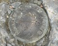
 view gallery view galleryW80.3 km | Geodetic Survey Gander 76G0263 in Canadian Benchmarks Benchmark Disk in wall of Old Post Office building in Gander, NL. posted by: GOTNL location: Newfoundland and Labrador, Canada date approved: 10/02/2006 last visited: 07/18/2015 |
 view gallery view gallerySW80.3 km | Newfoundland Crown Land surveys marker # 637 (016) in Canadian Benchmarks Newfoundland crown lands survey marker 637 (016) posted by: YQX52 location: Newfoundland and Labrador, Canada date approved: 05/22/2012 last visited: 05/22/2012 |
|