 view gallery view gallery NE0 km NE0 km
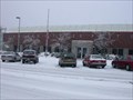
|   Blaine, WA 98230 Blaine, WA 98230
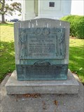
in U.S. Post Offices Located at 701 Harrison Avenue, Blaine, WA 98230. posted by:  Berkut Berkut location: Washington date approved: 01/16/2007 last visited: 10/25/2020 |
 view gallery view gallery W0.2 km W0.2 km
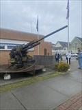
|  M1 90mm Anti-Aircraft Artillery at Blaine Washington M1 90mm Anti-Aircraft Artillery at Blaine Washington
in Static Artillery Displays 90mm Anti-Aircraft Artillery gun at 3rd and H Streets. Small veterans Memorial Park next to the Blaine Police Department. posted by:  mnerv mnerv location: Washington date approved: 09/25/2023 last visited: never |
 view gallery view gallery NW0.2 km NW0.2 km
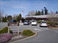
|  Whatcom County Library System - Blaine Public Library — Blaine, WA Whatcom County Library System - Blaine Public Library — Blaine, WA
in Libraries A really nice library serving the border community of Blaine. posted by: Dunbar Loop location: Washington date approved: 04/26/2012 last visited: 10/25/2020 |
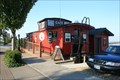 view gallery view galleryW0.3 km |  Little Red Caboose Café — Blaine, WA Little Red Caboose Café — Blaine, WA
in Train Cabooses An ex-Great Northern caboose that has gone through many uses after retirement. Now it is a café along Blaine's main street. posted by: Dunbar Loop location: Washington date approved: 10/25/2010 last visited: 10/25/2020 |
 view gallery view gallery S0.6 km S0.6 km
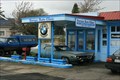
|  Foreign Auto Clinic — Blaine, WA Foreign Auto Clinic — Blaine, WA
in U.S. Route 99 - The Pacific Highway This vintage gas station is on Peace Portal Way, which was the main highway between Vancouver, BC and Seattle, WA until the late 1960s when Interstate 5 was built through Blaine. posted by: Dunbar Loop location: Washington date approved: 02/24/2022 last visited: never |
 view gallery view gallery SW0.6 km SW0.6 km
|  Foreign Auto Clinic — Blaine, WA Foreign Auto Clinic — Blaine, WA
in Vintage Gas Stations This vintage gas station is on Peace Portal Way, which was the main highway between Vancouver, BC and Seattle, WA until the late 1960s when Interstate 5 was built through Blaine. posted by: Dunbar Loop location: Washington date approved: 04/20/2013 last visited: 10/25/2020 |
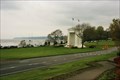 view gallery view galleryNW0.8 km |  Peace Arch State Park - Blaine, WA Peace Arch State Park - Blaine, WA
in State/Provincial Parks Peace Arch State Park, combined with Peach Arch Provincial Park, form an international park straddling the American and Canadian border. As long as you carry a valid passport or similar documentation you can wonder freely in either country. posted by: Dunbar Loop location: Washington date approved: 05/10/2013 last visited: 08/03/2022 |
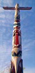 view gallery view galleryW1 km |  Phil Claymore Totem Pole — Blaine, WA Phil Claymore Totem Pole — Blaine, WA
in Outside Wooden Display Carvings Phil Claymore, a dedicate marine biologist, started this totem but died before it was finished. Some of his students finished the last third of the pole and the community raised it in Marine Park. posted by: Dunbar Loop location: Washington date approved: 04/26/2012 last visited: 01/30/2023 |
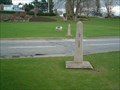
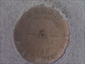 view gallery view galleryNE1 km |  WSDOT / Canadian Border Survey Mark WSDOT / Canadian Border Survey Mark
in U.S. Benchmarks Stumbled across this while on the way to an earthcache across the border. posted by: Devil Hunter location: Washington date approved: 09/01/2009 last visited: 08/28/2009 |
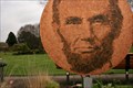 view gallery view galleryNW1.1 km |  RETIRED -- Two Sides of the Same Coin — Blaine, WA RETIRED -- Two Sides of the Same Coin — Blaine, WA
in Abraham Lincoln This artwork has been removed from Peace Arch State Park. posted by: Dunbar Loop location: Washington date approved: 04/19/2013 last visited: 08/16/2013 |
 view gallery view galleryNW1.1 km |  CNHS - Oregon Treaty of 1846 - Traité de l'Orégon de 1846 CNHS - Oregon Treaty of 1846 - Traité de l'Orégon de 1846
in Canadian National Historic Sites The plaque related to this National Historic Event is located within the Peace Arch Provincial Park in Surrey. La plaque reliée à cet événement historique national est située à l'intérieur du Parc Provincial Arche de la Paix à Surrey. posted by: Weathervane location: British Columbia, Canada date approved: 06/17/2012 last visited: 09/27/2018 |
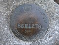 view gallery view galleryNW1.1 km |  86H1279 - Surrey, British Columbia, Canada 86H1279 - Surrey, British Columbia, Canada
in Canadian Benchmarks This BC Control Survey marker is located 12 feet north of the Canada/US border at the corner of 0 Avenue and Peace Park Drive in Surrey, British Columbia, Canada. posted by: The A-Team location: British Columbia, Canada date approved: 12/14/2015 last visited: 10/23/2016 |
 view gallery view galleryNW1.1 km | Boundary Monument 5X in Canadian Benchmarks Just up the hill and near pathway leading to 0 ave. posted by: South Surrey Scavengers location: British Columbia, Canada date approved: 11/20/2005 last visited: 10/11/2022 |
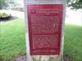
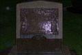
 view gallery view galleryNW1.1 km |  Oregon Treaty Centennial - Peace Arch State Park — Blaine, WA Oregon Treaty Centennial - Peace Arch State Park — Blaine, WA
in Washington Historical Markers The Oregon Treaty of 1846 established clarity on one of the most important issues in North America during the first half of the 19th century -- Would the United State or the United Kingdom control the Northwest Pacific coast. posted by: Dunbar Loop location: Washington date approved: 05/05/2013 last visited: 09/27/2018 |
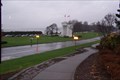
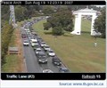 view gallery view galleryNW1.1 km |  Peace Arch Crossing - Southbound Peace Arch Crossing - Southbound
in Web Cameras This webcam provides a frequently updated view of the southbound traffic departing BC, Canada for Washington State. posted by: Berkut location: British Columbia, Canada date approved: 08/21/2007 last visited: 01/11/2023 |
 view gallery view galleryNW1.1 km | Boundary Monument 5 in Canadian Benchmarks It's very near the road. posted by: South Surrey Scavengers location: British Columbia, Canada date approved: 11/20/2005 last visited: 01/11/2023 |
 view gallery view galleryNW1.1 km | Boundary Monument 5C in Canadian Benchmarks First post to west of northbound lanes. posted by: South Surrey Scavengers location: British Columbia, Canada date approved: 11/20/2005 last visited: 01/11/2023 |
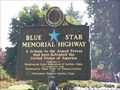 view gallery view galleryNW1.1 km |  Interstate 5 at the U.S. Canadian Border Blaine, WA Interstate 5 at the U.S. Canadian Border Blaine, WA
in Blue Star Memorial Highway Markers This Blue Star Memorial Highway Marker is located inside the Peace Arch State Park. posted by: budd-rdc location: Washington date approved: 09/27/2006 last visited: 01/11/2023 |
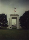 view gallery view galleryNW1.1 km |  International Peace Arch International Peace Arch
in Freestanding Arches Peace Arch State Park is a 20-acre day-use park commemorating treaties and agreements that arose from the war of 1812. posted by: Megadrile location: Washington date approved: 02/18/2008 last visited: 01/11/2023 |
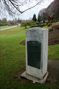
 view gallery view galleryNW1.1 km |  Peace Arch Boundary Monument - Canada/US Border Peace Arch Boundary Monument - Canada/US Border
in Kiwanis International Markers Kiwanis International erected a monument with two plaques directly on the border between Canada and the US in Peace Arch Park, near Surrey, British Columbia and Blaine, Washington. posted by: The A-Team location: British Columbia, Canada date approved: 07/06/2022 last visited: 01/11/2023 |
 view gallery view galleryNW1.1 km |  International Peace Arch International Peace Arch
in Border Crossings The International Peace Arch stands at the border of Washington State and British Columbia. posted by: b.b.wolf location: Washington date approved: 03/25/2009 last visited: 08/02/2022 |
 view gallery view galleryNW1.1 km | International Peace Arch in Freestanding Arches The International Peace Arch Sits in an International Park that exists in both the USA and Canada. posted by: b.b.wolf location: Washington date approved: 01/26/2009 last visited: 01/11/2023 |
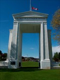 view gallery view galleryNW1.1 km |  Peace Arch - Blaine, WA, USA Peace Arch - Blaine, WA, USA
in Peace Memorials This Peace Arch is right on the USA/Canada border between Blaine, Washington and Surrey, British Columbia between Interstate 5 and Highway 99. posted by: PeterNoG location: Washington date approved: 10/14/2008 last visited: 01/11/2023 |
 view gallery view galleryNW1.1 km |  International Peace Arch International Peace Arch
in Signs of History A plaque describing the international peace arch posted by: b.b.wolf location: Washington date approved: 07/26/2009 last visited: 08/03/2022 |
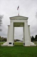 view gallery view galleryNW1.1 km |  Peace Arch — Surrey, BC Peace Arch — Surrey, BC
in War of 1812 Commemorating the signing of the Treaty of Ghent this 20.5 metres (67 ft) tall arch was built to honour the century of peace between the United States and Canada following the War of 1812.
-- posted by: Dunbar Loop location: British Columbia, Canada date approved: 04/24/2013 last visited: 01/11/2023 |
|