 view gallery view gallery NW4 km NW4 km
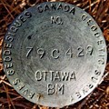
|   79C429 - Bridesville, BC 79C429 - Bridesville, BC
in Canadian Benchmarks What conscientious Benchmarker could drive along Highway 3 and not stop for a benchmark as easy to find as is 79C429? posted by:  T0SHEA T0SHEA location: British Columbia, Canada date approved: 08/27/2021 last visited: never |
 view gallery view galleryNW4.2 km |  Sidley-Lawless Cemetery - Bridesville, British Columbia Sidley-Lawless Cemetery - Bridesville, British Columbia
in Worldwide Cemeteries Sidley-Lawless Cemetery is named for two very small communities both of which no longer exist. The cemetery access is from a private drive off Sidley Mountain Road about 100 metres to cemetery. posted by: T0SHEA location: British Columbia, Canada date approved: 01/09/2016 last visited: never |
 view gallery view gallery NE5.8 km NE5.8 km
|  Sacred Heart Church - Rock Mountain, BC Sacred Heart Church - Rock Mountain, BC
in Roman Catholic Churches Though very near the road, this little country church is now sufficiently well hidden that we drove past it twice before finding it on the third try. posted by: T0SHEA location: British Columbia, Canada date approved: 09/08/2014 last visited: never |
 view gallery view galleryNE5.8 km | Sacred Heart Catholic Church - Rock Mountain, BC in Country Churches Though very near the road, this little country church is now sufficiently well hidden that we drove past it twice before finding it on the third try. posted by: T0SHEA location: British Columbia, Canada date approved: 09/08/2014 last visited: never |
 view gallery view galleryNE7.6 km |  Unknown 1 - Bridesville, British Columbia Unknown 1 - Bridesville, British Columbia
in Graves of the Unknown The Bridesville Cemetery is just off Hwy. 3. Take the Bridesville Townsite Road; continue south to cemetery about 1 km. There are numerous unknown gravesites with simple markers. posted by: T0SHEA location: British Columbia, Canada date approved: 01/04/2015 last visited: never |
 view gallery view galleryNE7.6 km | Bridesville Cemetery - Bridesville, British Columbia in Worldwide Cemeteries The Bridesville Cemetery is just off Hwy. 3. Take the Bridesville Townsite Road; continue south to cemetery about 1 km. This is a small cemetery; however there is a large sign at the entrance. posted by: T0SHEA location: British Columbia, Canada date approved: 09/15/2014 last visited: never |
 view gallery view gallery W8.5 km W8.5 km
|  Raven - Osoyoos, British Columbia Raven - Osoyoos, British Columbia
in Figurative Public Sculpture Raven is located on a Hwy. 3. There are 9 animal sculptures all within 3 km of each other. From Osoyoos the first is 16 km east from the bridge. From Bridesville 15 km west. All the sculptures are on public display and visited at any time. posted by: T0SHEA location: British Columbia, Canada date approved: 11/06/2014 last visited: never |
 view gallery view galleryW8.5 km |  Raven - Osoyoos, British Columbia Raven - Osoyoos, British Columbia
in Roadside Attractions Raven is located on a Hwy. 3. There are 9 animal sculptures all within 3 km of each other. From Osoyoos the first is 16 km east from the bridge. From Bridesville 15 km west. All the sculptures are on public display and visited at any time. posted by: T0SHEA location: British Columbia, Canada date approved: 11/04/2014 last visited: never |
 view gallery view galleryW8.9 km |  Anarchist Highway Webcam - Bridesville, BC Anarchist Highway Webcam - Bridesville, BC
in Web Cameras This BC Highways Webcam is 9 km. west of the Anarchist Summit, east of Osoyoos on Highway 3, the Crowsnest Highway. posted by: T0SHEA location: British Columbia, Canada date approved: 08/19/2013 last visited: 12/31/2013 |
 view gallery view galleryW8.9 km |  Anarchist Summit WX Station- Osoyoos, BC Anarchist Summit WX Station- Osoyoos, BC
in Weather Stations On the north side of the Crowsnest Highway at a gravel pit, this is a BC Highways weather station. posted by: T0SHEA location: British Columbia, Canada date approved: 01/07/2015 last visited: never |
 view gallery view galleryNE9.3 km |  Rock Creek Canyon Bridge South - 902 Metres - Rock Creek, BC Rock Creek Canyon Bridge South - 902 Metres - Rock Creek, BC
in Elevation Signs This large, multi-span, steel deck truss bridge carries the Crowsnest Highway, AKA Highway over the deep Rock Creek Canyon. At each end of the bridge is an elevation sign. posted by: T0SHEA location: British Columbia, Canada date approved: 08/29/2021 last visited: never |
 view gallery view galleryNE9.7 km | Rock Creek Canyon Bridge North - Rock Creek, BC - 902 Metres in Elevation Signs This large, multi-span, steel deck truss bridge carries the Crowsnest Highway, AKA Highway over the deep Rock Creek Canyon. At each end of the bridge is an elevation sign. posted by: T0SHEA location: British Columbia, Canada date approved: 08/29/2021 last visited: never |
 view gallery view galleryNE9.7 km |  Rock Creek Canyon Bridge - Rock Creek, BC Rock Creek Canyon Bridge - Rock Creek, BC
in Wikipedia Entries This large, multi-span, steel deck truss bridge carries the Crowsnest Highway, AKA Highway 3, over the deep Rock Creek Canyon. posted by: T0SHEA location: British Columbia, Canada date approved: 08/28/2021 last visited: never |
 view gallery view galleryNE9.7 km |  Rock Creek Canyon Bridge - Rock Creek, BC Rock Creek Canyon Bridge - Rock Creek, BC
in Truss Bridges This large, multi-span, steel deck truss bridge carries the Crowsnest Highway, AKA Highway 3, over the deep Rock Creek Canyon. posted by: T0SHEA location: British Columbia, Canada date approved: 08/28/2021 last visited: never |
 view gallery view galleryW9.8 km | Caribou - Osoyoos, British Columbia in Roadside Attractions Caribou is located on a Hwy. 3. There are 9 animal sculptures all within 3 km of each other. From Osoyoos the first is 16 km east from the bridge. From Bridesville 15 km west. All the sculptures are on public display and visited at any time. posted by: T0SHEA location: British Columbia, Canada date approved: 11/04/2014 last visited: never |
 view gallery view galleryW9.8 km | Caribou - Osoyoos, British Columbia in Figurative Public Sculpture Caribou is located on a Hwy. 3. There are 9 animal sculptures all within 3 km of each other. From Osoyoos the first is 16 km east from the bridge. From Bridesville 15 km west. All the sculptures are on public display and visited at any time. posted by: T0SHEA location: British Columbia, Canada date approved: 11/06/2014 last visited: never |
 view gallery view galleryW9.8 km | Wapiti - Osoyoos, British Columbia in Figurative Public Sculpture Wapiti is located on a Hwy. 3. There are 9 animal sculptures all within 3 km of each other. From Osoyoos the first is 16 km east from the bridge. From Bridesville 15 km west. All the sculptures are on public display and can be visited at any time. posted by: T0SHEA location: British Columbia, Canada date approved: 11/06/2014 last visited: never |
 view gallery view galleryW9.8 km | Wapiti - Osoyoos, British Columbia in Roadside Attractions Wapiti is located on a Hwy. 3. There are 9 animal sculptures all within 3 km of each other. From Osoyoos the first is 16 km east from the bridge. From Bridesville 15 km west. All the sculptures are on public display and can be visited at any time. posted by: T0SHEA location: British Columbia, Canada date approved: 11/05/2014 last visited: never |
 view gallery view galleryW10.5 km |  Sasquatch - Osoyoos, BC, Canada Sasquatch - Osoyoos, BC, Canada
in Epic Beings and Creatures This Bronze statue is located 18 kilometres east of the small city of Osoyoos along Highway #3. posted by: bcrockcrawler, xstitcher, & BMXer location: British Columbia, Canada date approved: 05/15/2010 last visited: 09/03/2015 |
 view gallery view galleryW10.5 km | Sasquatch - Osoyoos, British Columbia in Roadside Attractions Sasquatch is located on a Hwy. 3. There are 9 sculptures all within 3 km of each other. From Osoyoos the first is 16 km east from the bridge. From Bridesville 15 km west. All the sculptures are on public display and visited at any time. posted by: T0SHEA location: British Columbia, Canada date approved: 11/04/2014 last visited: 09/03/2015 |
 view gallery view galleryW10.6 km | MON 121 - Osoyoos, BC in Canadian Benchmarks The fourth border monument east of Osoyoos Lake, MON 121 is just where one would expect to find it - on the Canada-U.S. border. posted by: T0SHEA location: British Columbia, Canada date approved: 08/27/2021 last visited: never |
 view gallery view galleryW10.6 km |  MONUMENT 121 - Okanogan County, WA MONUMENT 121 - Okanogan County, WA
in U.S. Benchmarks The fourth border monument east of Osoyoos Lake, MON 121 is just where one would expect to find it - on the Canada-U.S. border. posted by: T0SHEA location: Washington date approved: 08/27/2021 last visited: never |
 view gallery view galleryW10.6 km |  MONUMENT 121 - Okanogan County, WA MONUMENT 121 - Okanogan County, WA
in U.S. Historic Survey Stones and Monuments The fourth border monument east of Osoyoos Lake, MON 121 is just where one would expect to find it - on the Canada-U.S. border. posted by: T0SHEA location: Washington date approved: 08/27/2021 last visited: never |
 view gallery view galleryW10.6 km |  MONUMENT 121 - Okanogan County, WA MONUMENT 121 - Okanogan County, WA
in Public Land Survey Marks The fourth border monument east of Osoyoos Lake, MON 121 is just where one would expect to find it - on the Canada-U.S. border. posted by: T0SHEA location: Washington date approved: 08/28/2021 last visited: never |
 view gallery view galleryW10.6 km | Screaming Eagle - Osoyoos, British Columbia in Figurative Public Sculpture Screaming Eagle is located on a Hwy. 3. There are 9 animal sculptures all within 3 km of each other. From Osoyoos the first is 16 km east from the bridge. From Bridesville 15 km west. All the sculptures are on public display and visited at any time. posted by: T0SHEA location: British Columbia, Canada date approved: 11/06/2014 last visited: never |
|