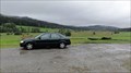
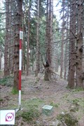
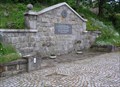
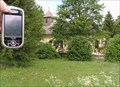
 view gallery view gallery S0.2 km S0.2 km
|   'You Are Here' Map at Brezova Lada, CZE 'You Are Here' Map at Brezova Lada, CZE
in 'You Are Here' Maps This map is one of many in Sumava National Park and Protected Landscape Area. posted by:  walden2 walden2 location: Jihočeský kraj, Czechia date approved: 09/27/2011 last visited: 04/19/2012 |
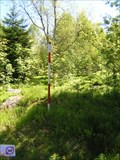
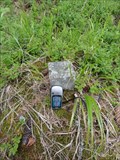 view gallery view gallery SE0.6 km SE0.6 km
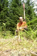
|  TB 3907-2 Jilm TB 3907-2 Jilm
in Czech Geodetic Points TrB na kopci Jilm - 931m Mezi Borovou Ladou a Horní Vltavicí posted by: Gotici location: Jihočeský kraj, Czechia date approved: 08/07/2011 last visited: 10/01/2011 |
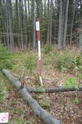
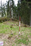 view gallery view gallery N2.3 km N2.3 km
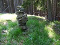
| TB 3906-21 Lisci hora in Czech Geodetic Points Trigonometrický bod jihozápadne od Vimperka posted by:  pavlikVB pavlikVB location: Jihočeský kraj, Czechia date approved: 05/02/2011 last visited: 08/14/2021 |
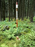
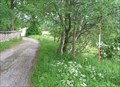
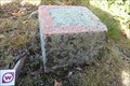 view gallery view gallerySE2.6 km | TB 3907-5 Orlov in Czech Geodetic Points Trigonometrický bod na Šumave posted by: pavlikVB location: Jihočeský kraj, Czechia date approved: 11/04/2012 last visited: never |
 view gallery view gallery E3.4 km E3.4 km
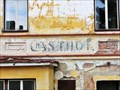
|  Nejstarsi hospoda na Sumave - Horni Vltavice, Czech Republic Nejstarsi hospoda na Sumave - Horni Vltavice, Czech Republic
in Ghost Signs Nejstarsi hospoda na Sumave // Das älteste Gasthaus im Böhmerwald // The oldest inn in the Bohemian Forest posted by: ToRo61 location: Jihočeský kraj, Czechia date approved: 11/13/2013 last visited: 07/11/2022 |
 view gallery view gallery NE4.3 km NE4.3 km
| TB 3901-16 Obrovec in Czech Geodetic Points Na vrcholu tisícovky Obrovec / On the top of Obrovec hill posted by: Mamuti location: Jihočeský kraj, Czechia date approved: 08/29/2010 last visited: 08/14/2021 |
 view gallery view gallery NW4.5 km NW4.5 km
| TB 3906-18 Homolice in Czech Geodetic Points Trigonometrický bod nad Borovou Ladou posted by: pavlikVB location: Jihočeský kraj, Czechia date approved: 06/16/2010 last visited: never |
 view gallery view galleryNW4.7 km | TB 3906-14 Nad Cernými Lady in Czech Geodetic Points Trigonometrický bod severovýchodne od Borových Lad /// Geodetic point nord-east from Borová Lada posted by: Ursus PiPa location: Jihočeský kraj, Czechia date approved: 08/05/2011 last visited: never |
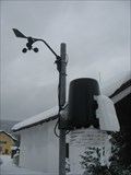 view gallery view galleryNE5.3 km |  Amateur weather station Kubova Hut Amateur weather station Kubova Hut
in Weather Stations Small automatic amateur weather station posted by: Ponik & team location: Jihočeský kraj, Czechia date approved: 02/14/2010 last visited: 03/18/2015 |
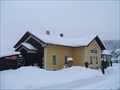 view gallery view galleryNE5.3 km |  Kubova Hut - Czech Republic Kubova Hut - Czech Republic
in Train Stations/Depots The highest railway station in Czech Lands. The altitude is 995m. posted by: haggaeus location: Jihočeský kraj, Czechia date approved: 02/15/2010 last visited: 08/02/2015 |
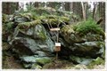 view gallery view galleryN5.3 km |  Svetlá hora - Šumava, CZ Svetlá hora - Šumava, CZ
in Summit Registers Návštevní kniha na vrcholu Svetlé hory. /// Summit register on the top of Svetlá hora. posted by: Ursus PiPa location: Jihočeský kraj, Czechia date approved: 01/20/2012 last visited: 08/14/2021 |
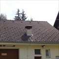 view gallery view galleryNW5.3 km |  Venkovní varovná siréna, Borová Lada, Czechia Venkovní varovná siréna, Borová Lada, Czechia
in Outdoor Warning Sirens [CZ] Venkovní siréna systému varování obyvatelstva na streše požární zbrojnice Borová Lada, okres Prachatice. [ENG] Outdoor siren of the system of warning of the population on the roof of a firehouse Borová Lada, district Prachatice. posted by: ashberry location: Jihočeský kraj, Czechia date approved: 08/15/2019 last visited: never |
 view gallery view galleryN5.5 km | TB 3906-15 Svetla hora in Czech Geodetic Points Trigonometrický bod jihozápadne od Vimperka posted by: pavlikVB location: Jihočeský kraj, Czechia date approved: 05/02/2011 last visited: 08/14/2021 |
 view gallery view galleryNW5.5 km |  Ceská pošta - 384 92 Borová Lada, Czechia Ceská pošta - 384 92 Borová Lada, Czechia
in European Post Offices Local post office in Borová Lada c.p.54, Prachatice district. posted by: ashberry location: Jihočeský kraj, Czechia date approved: 08/15/2019 last visited: never |
 view gallery view galleryNW5.6 km | TB 3906-16 Vyhlidka in Czech Geodetic Points Trigonometrický bod na vrcholu tisícovky Vyhlídka (1 068 m) ///
Geodetic point on the summit of the mountain named Vyhlídka ( 1 068 m) posted by: Ursus PiPa location: Jihočeský kraj, Czechia date approved: 05/04/2011 last visited: 09/23/2011 |
 view gallery view galleryNW6.3 km |  SVINNÁ LADA 915 m, Czech republic SVINNÁ LADA 915 m, Czech republic
in Direction and Distance Arrows Turistický rozcestník pri odbocce na naucnou stezku Chalupská slat. Tourist direction and distance arrows at the turn to the Chalupská slat educational trail. posted by: davidb11 location: Jihočeský kraj, Czechia date approved: 08/05/2022 last visited: never |
 view gallery view gallerySE6.9 km | BTP 3164 Horní Vltavice - Lenora in Czech Geodetic Points Bod 1.rádu základního tíhového bodového pole. posted by: pavlikVB location: Jihočeský kraj, Czechia date approved: 06/08/2009 last visited: 05/22/2014 |
 view gallery view gallery W7.1 km W7.1 km
| TB 3906-22 U kostela in Czech Geodetic Points Trigonometrický bod u Knížecích Plání na Šumave posted by: pavlikVB location: Jihočeský kraj, Czechia date approved: 06/16/2010 last visited: 08/26/2010 |
 view gallery view galleryN7.1 km | TB 3906-9 Kamenna in Czech Geodetic Points Trigonometrický bod jihozápadne od Vimperka posted by: pavlikVB location: Jihočeský kraj, Czechia date approved: 05/02/2011 last visited: 07/29/2011 |
 view gallery view galleryNE7.7 km | BTP 3163,02 Vimperk - Korkusova Hut in Czech Geodetic Points Bod 2.rádu základního tíhového bodového pole. posted by: pavlikVB location: Jihočeský kraj, Czechia date approved: 06/08/2009 last visited: never |
 view gallery view galleryNE7.7 km | TB 3901-11 Korkusova hut, kostel in Czech Geodetic Points Trigonometrický bod umístený na kostele posted by: pavlikVB location: Jihočeský kraj, Czechia date approved: 06/08/2009 last visited: never |
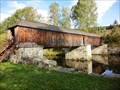
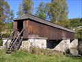 view gallery view gallerySE7.7 km |  Rechle u Lenory / Lenora-covered bridge Rechle u Lenory / Lenora-covered bridge
in Covered Bridges Krytý drevený most pres Vltavu na konci Lenory smerem na Volary.
EN:Covered bridge across Moldau river in Lenora. posted by: bartusko location: Jihočeský kraj, Czechia date approved: 05/11/2010 last visited: 10/08/2022 |
 view gallery view gallerySE7.7 km |  No. 112, Lenora-Vltava, CZ No. 112, Lenora-Vltava, CZ
in Tourist Stamps Photos Lenora Town, Vltava river. posted by: ToRo61 location: Jihočeský kraj, Czechia date approved: 10/31/2013 last visited: 10/08/2022 |
 view gallery view gallerySE7.7 km |  Rechle u Lenory - Czech Republic Rechle u Lenory - Czech Republic
in Satellite Imagery Oddities The roofed wooden bridge [CZ: Rechle] posted by: ToRo61 location: Jihočeský kraj, Czechia date approved: 01/27/2017 last visited: 10/08/2022 |
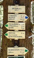 view gallery view galleryE8 km | Záton (žst) in Direction and Distance Arrows [CZ]Rozcestník je na križovatce modré se zelenou TZ u železnicní stanice.
[EN]The signpost is at the junction of blue and green track near railway station. posted by: prokestom location: Jihočeský kraj, Czechia date approved: 05/16/2019 last visited: 07/17/2019 |
|