 view gallery view gallery NE4.7 km NE4.7 km
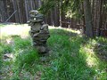
|   TB 3906-22 U kostela TB 3906-22 U kostela
in Czech Geodetic Points Trigonometrický bod u Knížecích Plání na Šumave posted by:  pavlikVB pavlikVB location: Jihočeský kraj, Czechia date approved: 06/16/2010 last visited: 08/26/2010 |
 view gallery view gallery N5 km N5 km
|  TP Siebensteinkopf - Bayern TP Siebensteinkopf - Bayern
in German Trigonometric Points TP on the top of Siebensteinkopf in the Bayerischer Wald. posted by:  Ursus PiPa Ursus PiPa location: Bayern, Germany date approved: 04/11/2012 last visited: never |
 view gallery view gallery W5.6 km W5.6 km
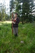
|  Lusen (1373m) - Bayerischer Wald, Germany Lusen (1373m) - Bayerischer Wald, Germany
in Mountain Summits Der Lusen - Luzný posted by: Waupe location: Bayern, Germany date approved: 01/06/2011 last visited: 09/21/2016 |
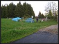 view gallery view galleryN6 km |  Bucina camp Bucina camp
in Free Campsites Bucina camp posted by: Waupe location: Jihočeský kraj, Czechia date approved: 01/05/2011 last visited: 09/28/2011 |
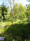
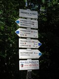
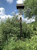
 view gallery view galleryN6 km |  Turisticky ukazatel "U pramene Vltavy" - Kvilda, Czech Republic Turisticky ukazatel "U pramene Vltavy" - Kvilda, Czech Republic
in Direction and Distance Arrows CZ: Turisticky ukazetel "U pramene Vltavy" EN: Direction and distance arrows "Near Vltava spring" posted by: honza.h location: Jihočeský kraj, Czechia date approved: 04/06/2013 last visited: 05/24/2015 |
 view gallery view galleryN6 km | BTP 3168 Kvilda - Bucina in Czech Geodetic Points Bod 2.rádu základního tíhového bodového pole posted by: pavlikVB location: Jihočeský kraj, Czechia date approved: 06/16/2010 last visited: 08/11/2011 |
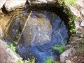 view gallery view galleryN6.3 km |  Pramen Vltavy /// Moldau spring Pramen Vltavy /// Moldau spring
in Natural Springs Pramen Vltavy /// Moldau spring posted by: Ursus PiPa location: Jihočeský kraj, Czechia date approved: 07/29/2011 last visited: 02/26/2023 |
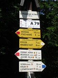
 view gallery view galleryN6.3 km | Turisticky ukazatel "Pramen Vltavy" - Kvilda, Czech Republic in Direction and Distance Arrows CZ: Turisticky ukazetel "Pramen Vltavy" EN: Direction and distance arrows "Vltava spring" posted by: honza.h location: Jihočeský kraj, Czechia date approved: 04/05/2013 last visited: 05/24/2015 |
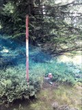
 view gallery view galleryN6.3 km | TB 3911-11 Poštovní hora in Czech Geodetic Points Trigonometrický bod na vrcholu hory Stráž. /// Geodetic point on the top of Stráž. posted by: Ursus PiPa location: Jihočeský kraj, Czechia date approved: 07/28/2011 last visited: 09/25/2011 |
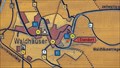
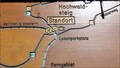 view gallery view galleryW6.4 km |  'You Are Here' Map at Lusenparkplatz, GER 'You Are Here' Map at Lusenparkplatz, GER
in 'You Are Here' Maps One of many splendid maps in Nationalpark Bayerischer Wald. posted by: walden2 location: Bayern, Germany date approved: 12/21/2011 last visited: 09/21/2016 |
 view gallery view galleryW6.8 km | 'You Are Here' Map at Pavillon Bohmweg, GER in 'You Are Here' Maps One of many splendid wood maps in Nationalpark Bayerischer Wald. posted by: walden2 location: Bayern, Germany date approved: 12/21/2011 last visited: 09/21/2016 |
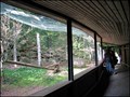
 view gallery view galleryW6.8 km |  Owl Aviary, Neuschönau, Germany Owl Aviary, Neuschönau, Germany
in Aviaries Aviary in forest ZOO above Neuschönau. posted by: Dáin & Olík location: Bayern, Germany date approved: 05/13/2011 last visited: 09/15/2016 |
 view gallery view galleryN6.9 km | TB 3911-10 Cerná hora in Czech Geodetic Points Trigonometrický bod na vrcholu šumavské tisícovky Cerná hora /// Geodetic point on the top of Cerná hora posted by: Ursus PiPa location: Plzeňský kraj, Czechia date approved: 08/22/2011 last visited: never |
 view gallery view galleryW7.6 km | Scavenger Birds Aviary, Neuschönau, Germany in Aviaries Aviary in forest ZOO above Neuschönau. posted by: Dáin & Olík location: Bayern, Germany date approved: 05/13/2011 last visited: 09/15/2016 |
 view gallery view gallery SW7.6 km SW7.6 km
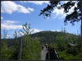
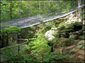
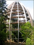
|  "Tree Top Walk" Tower, Neuschönau, Germany "Tree Top Walk" Tower, Neuschönau, Germany
in Look-Out Towers Great new look out tower in National Park Bavarian Forest. posted by: Dáin & Olík location: Bayern, Germany date approved: 05/10/2011 last visited: 10/25/2017 |
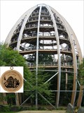 view gallery view gallerySW7.6 km |  Nr. 517, Neuchönau - Baumwipfelpfad - Nationalpark - Bayerischer Wald, DE Nr. 517, Neuchönau - Baumwipfelpfad - Nationalpark - Bayerischer Wald, DE
in Tourist Stamps Photos 44m vysoká vyhlídková vež / 44m high look out tower in Neuchenau, GER posted by: Arogant location: Bayern, Germany date approved: 12/15/2011 last visited: 09/15/2016 |
 view gallery view galleryW7.9 km | 'You Are Here' Map in at Lusenstrasse, GER in 'You Are Here' Maps One of many splendid maps in Nationalpark Bayerischer Wald. posted by: walden2 location: Bayern, Germany date approved: 12/21/2011 last visited: 09/21/2016 |
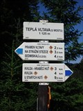 view gallery view galleryN8.2 km | Turisticky ukazatel "Tepla Vltava (u mostu)" - Kvilda, Czech Republic in Direction and Distance Arrows CZ: Turisticky ukazetel "Tepla Vltava (u mostu)" EN: Direction and distance arrows "Tepla Vltava (at the bridge)" posted by: honza.h location: Jihočeský kraj, Czechia date approved: 04/05/2013 last visited: 05/24/2015 |
 view gallery view galleryNE8.7 km | TB 3906-18 Homolice in Czech Geodetic Points Trigonometrický bod nad Borovou Ladou posted by: pavlikVB location: Jihočeský kraj, Czechia date approved: 06/16/2010 last visited: never |
 view gallery view galleryNE9 km | TB 3906-16 Vyhlidka in Czech Geodetic Points Trigonometrický bod na vrcholu tisícovky Vyhlídka (1 068 m) ///
Geodetic point on the summit of the mountain named Vyhlídka ( 1 068 m) posted by: Ursus PiPa location: Jihočeský kraj, Czechia date approved: 05/04/2011 last visited: 09/23/2011 |
 view gallery view galleryN9.7 km | TB 3911-6 Sedmikámen in Czech Geodetic Points Trigonometrický bod na vrcholovém skalisku tisícovky Certuv vrch (1 244 m ) /// Geodetic point on the top of the mountain named Certuv vrch ( 1 244 m) posted by: Ursus PiPa location: Plzeňský kraj, Czechia date approved: 05/26/2011 last visited: 09/25/2011 |
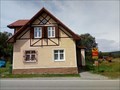 view gallery view galleryNE9.8 km |  Ceská pošta - 384 92 Borová Lada, Czechia Ceská pošta - 384 92 Borová Lada, Czechia
in European Post Offices Local post office in Borová Lada c.p.54, Prachatice district. posted by: ashberry location: Jihočeský kraj, Czechia date approved: 08/15/2019 last visited: never |
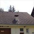 view gallery view galleryNE9.8 km |  Venkovní varovná siréna, Borová Lada, Czechia Venkovní varovná siréna, Borová Lada, Czechia
in Outdoor Warning Sirens [CZ] Venkovní siréna systému varování obyvatelstva na streše požární zbrojnice Borová Lada, okres Prachatice. [ENG] Outdoor siren of the system of warning of the population on the roof of a firehouse Borová Lada, district Prachatice. posted by: ashberry location: Jihočeský kraj, Czechia date approved: 08/15/2019 last visited: never |
 view gallery view galleryNE10.1 km | SVINNÁ LADA 915 m, Czech republic in Direction and Distance Arrows Turistický rozcestník pri odbocce na naucnou stezku Chalupská slat. Tourist direction and distance arrows at the turn to the Chalupská slat educational trail. posted by: davidb11 location: Jihočeský kraj, Czechia date approved: 08/05/2022 last visited: never |
 view gallery view gallery E10.6 km E10.6 km
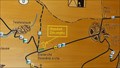
| 'You Are Here' Map at Brezova Lada, CZE in 'You Are Here' Maps This map is one of many in Sumava National Park and Protected Landscape Area. posted by: walden2 location: Jihočeský kraj, Czechia date approved: 09/27/2011 last visited: 04/19/2012 |
|