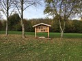
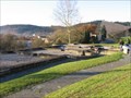
 view gallery view gallery SE6.3 km SE6.3 km
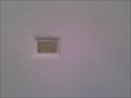
|   Insektenhotel Horner Hütte bei Horn, Ostalbkreis Insektenhotel Horner Hütte bei Horn, Ostalbkreis
in Insect Hotels Ein Insektenhotel in der Nähe der Horner Hütte bei Horn im Ostalbkreis. posted by:  ede-v ede-v location: Baden-Württemberg, Germany date approved: 10/22/2017 last visited: 10/23/2017 |
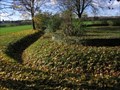
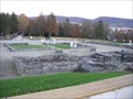
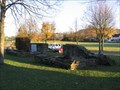 view gallery view gallerySE10.3 km |  Kohorten-Kastell Böbingen im Remstal Kohorten-Kastell Böbingen im Remstal
in Ancient Roman Civilization The remains of a Roman fort in the southwest German town of Böbingen. posted by: RakeInTheCache location: Baden-Württemberg, Germany date approved: 11/19/2006 last visited: never |
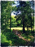 view gallery view gallery E10.8 km E10.8 km
|  Holzbrücke - Rotbachtal, Abtsgmünd Holzbrücke - Rotbachtal, Abtsgmünd
in Hiking Path Footbridges Holzbrücke zum Überqueren der Rot im Rotbachtal bei Abtsgmünd. posted by: Biglailo location: Baden-Württemberg, Germany date approved: 06/18/2017 last visited: never |
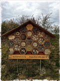 view gallery view gallerySE11.1 km | Insect Hotel Schweizer - Mögglingen, Germany in Insect Hotels Insect hotel near Mögglingen. posted by: Biglailo location: Baden-Württemberg, Germany date approved: 10/22/2017 last visited: never |
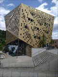 view gallery view gallery SW12.7 km SW12.7 km
|  Forum Gold und Silber, Schwäbisch Gmünd, Baden-Württemberg, Germany Forum Gold und Silber, Schwäbisch Gmünd, Baden-Württemberg, Germany
in Odd-Shaped Buildings Ein Gebäude mit außergewöhnlicher Fassade ---- A building with an extraordinary façade posted by: Windego1 location: Baden-Württemberg, Germany date approved: 07/18/2023 last visited: 07/17/2023 |
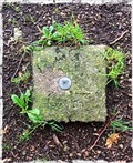 view gallery view gallerySE13.5 km |  TP Große Scheuer - Heidenheim, BW, Germany TP Große Scheuer - Heidenheim, BW, Germany
in German Trigonometric Points Trigonometrischer Punkt ‚Große Scheuer‘ /
Trigonometric Point ‚Große Scheuer‘ posted by: Biglailo location: Baden-Württemberg, Germany date approved: 08/13/2017 last visited: never |
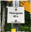 view gallery view gallerySE13.8 km |  685m - Pliksburggrotten, Heubach, BW, Germany 685m - Pliksburggrotten, Heubach, BW, Germany
in Elevation Signs A small sign located above Heubach, which indicates an elevation of 685 meters above sea level. posted by: Biglailo location: Baden-Württemberg, Germany date approved: 08/13/2017 last visited: never |
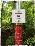 view gallery view gallerySE14 km | 670m - Rosenstein Süd, Heubach, BW, Germany in Elevation Signs A small sign located above Heubach, which indicates an elevation of 670 meters above sea level. posted by: Biglailo location: Baden-Württemberg, Germany date approved: 08/13/2017 last visited: never |
 view gallery view gallerySW14.8 km | Kastellbad Schirenhof in Ancient Roman Civilization Excavated remains of a Roman bath in the southwest German city of Schwäbisch Gmund. posted by: RakeInTheCache location: Baden-Württemberg, Germany date approved: 11/19/2006 last visited: 05/17/2014 |
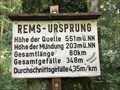 view gallery view gallerySE15.4 km | Höhenmarke Rems-Ursprung, Essingen bei Aalen, Germany - 551 Meter in Elevation Signs Höhenmarke bei Essingen / in der Nähe von Aalen / Ostalbkreis / Germany posted by: ede-v location: Baden-Württemberg, Germany date approved: 09/20/2017 last visited: 10/03/2017 |
 view gallery view gallerySW16.6 km | Limes Germanicus - WP 12/11 in Ancient Roman Civilization Reconstructed remains of a Roman watchtower along the Upper Germanic Limes border near the Southwest German village of Lorch. posted by: RakeInTheCache location: Baden-Württemberg, Germany date approved: 11/19/2006 last visited: never |
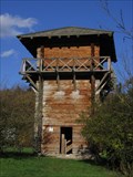 view gallery view gallerySW16.6 km | Lorch Roman Watchtower Reconstruction in Ancient Roman Civilization Reconstructed wooden Roman watchtower along the Upper Germanic Limes border near the Southwest German village of Lorch. posted by: RakeInTheCache location: Baden-Württemberg, Germany date approved: 11/19/2006 last visited: 07/17/2023 |
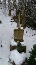 view gallery view gallery NE16.6 km NE16.6 km
|  Pilgerkreuz Hohenberg - Hohenberg, Baden-Württemberg, Germany Pilgerkreuz Hohenberg - Hohenberg, Baden-Württemberg, Germany
in Way of St. James Ein Kreuz am Jacobsweg bei Hoheberg nahe bei der kleine Grotte - A cross at the Way of St. James near Hoheberg, quite close to the small cave posted by: Windego1 location: Baden-Württemberg, Germany date approved: 06/16/2018 last visited: never |
 view gallery view gallerySW16.7 km | 347 Meter Kloster Lorch, Lorch, Baden-Württemberg, Germany in Elevation Signs Schild mit Höhenangabe u. UTM-Koordinaten am Kloster Lorch ---- Sign with altitude and UTM coordinates at Lorch Monastry posted by: Windego1 location: Baden-Württemberg, Germany date approved: 07/18/2023 last visited: 07/17/2023 |
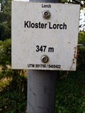 view gallery view gallerySW16.7 km |  UTM: U32 551756/5405422, Kloster Lorch, Lorch, Germany UTM: U32 551756/5405422, Kloster Lorch, Lorch, Germany
in Permanent Geographic Coordinates Schild mit Höhenangabe am Kloster Lorch zeigt auch die UTM Koordinaten ---- Elevation sign at the Monastry of Lorch showing also UTM Coordinates posted by: Windego1 location: Baden-Württemberg, Germany date approved: 07/18/2023 last visited: 07/14/2023 |
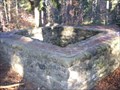
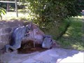 view gallery view galleryNE17.1 km | Jakobsbrunnen - Rosenberg, BW, Germany in Way of St. James --- Engl. --- Way of St. James from Hohenberg to Rosenberg, near Rosenberg, you find this little well --- german --- Am Jakobsweg zwischen Hohenberg und Rosenberg findet sich dieser schöne Brunnen, nahe Rosenberg. posted by: Windego1 location: Baden-Württemberg, Germany date approved: 08/12/2013 last visited: 09/27/2017 |
 view gallery view gallery W17.1 km W17.1 km
| Limes Germanicus - Welzheim Ostkastell in Ancient Roman Civilization Welzheim belonged to the most important garrisons of the Upper-Germanic Limes. posted by: RakeInTheCache location: Baden-Württemberg, Germany date approved: 11/19/2006 last visited: 05/17/2014 |
 view gallery view galleryW17.2 km | Limes Germanicus - Göckelersturm - WP 9/134 in Ancient Roman Civilization Reconstructed remains of a roman watchtower along the Upper Germanic Limes border near the Southwest German village of Welzheim. posted by: RakeInTheCache location: Baden-Württemberg, Germany date approved: 11/19/2006 last visited: 10/12/2011 |
 view gallery view gallery N17.2 km N17.2 km
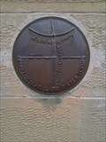
| Rathaus Obersontheim N49°03'28" E009°53'57" in Permanent Geographic Coordinates --- engl. --- This geo-coordinates may be found at the cityhall of Obersontheim --- german --- Diese Geo-Koordinaten können am Rathaus des Ortes Obersontheim gefunden werden. posted by: Windego1 location: Baden-Württemberg, Germany date approved: 08/16/2013 last visited: 12/26/2014 |
 view gallery view galleryN17.2 km | Rathaus Obersontheim - Germany. 369m in Elevation Signs Höhenmarke am Rathaus in Obersontheim - Straßenseite *** Elevation-Benchmark at the town hall of Obersontheim posted by: Windego1 location: Baden-Württemberg, Germany date approved: 05/22/2014 last visited: never |
 view gallery view galleryN17.2 km |  Höhenmarke - Rathaus Obersontheim, Baden-Württemberg Höhenmarke - Rathaus Obersontheim, Baden-Württemberg
in German Benchmarks Höhenmarke am Rathaus in Obersontheim - Straßenseite *** Elevation-Benchmark at the town hall of Obersontheim posted by: Windego1 location: Baden-Württemberg, Germany date approved: 05/20/2014 last visited: never |
 view gallery view galleryW17.2 km | Limes Germanicus - Fortlet "Rötelsee" - WP 9/128 in Ancient Roman Civilization Small Roman fort along the Upper Germanic Limes border near the Southwest German village of Welzheim. posted by: RakeInTheCache location: Baden-Württemberg, Germany date approved: 11/18/2006 last visited: 05/17/2014 |
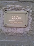 view gallery view galleryN17.4 km | Höhenmarke Oberfischach, 417m in Elevation Signs --- engl. --- At the church of Oberfischach this elevation sign can be found --- german --- An der Kirche von Oberfischach befindet sich diese Höhenmarke posted by: Windego1 location: Baden-Württemberg, Germany date approved: 08/07/2013 last visited: never |
 view gallery view galleryN17.4 km | Kirche Oberfischach N 49°03'30" E 009°50'00" - inexactely! in Permanent Geographic Coordinates --- engl. --- Plate showing the coordinates of the churchtower --- german --- Markierungsplatte für die Kirchturm-Koordinaten posted by: Windego1 location: Baden-Württemberg, Germany date approved: 08/07/2013 last visited: never |
 view gallery view gallerySE17.4 km | Aalen - Kastell und Limesmuseum in Ancient Roman Civilization On this site was the largest Roman cavalry fort north of the Alps and was built around 160 A.D. posted by: RakeInTheCache location: Baden-Württemberg, Germany date approved: 11/19/2006 last visited: 05/07/2017 |
|