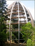
 view gallery view gallery E1.3 km E1.3 km
|   Nr. 517, Neuchönau - Baumwipfelpfad - Nationalpark - Bayerischer Wald, DE Nr. 517, Neuchönau - Baumwipfelpfad - Nationalpark - Bayerischer Wald, DE
in Tourist Stamps Photos 44m vysoká vyhlídková vež / 44m high look out tower in Neuchenau, GER posted by:  Arogant Arogant location: Bayern, Germany date approved: 12/15/2011 last visited: 09/15/2016 |
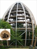
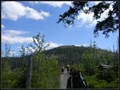
 view gallery view galleryE1.3 km |  "Tree Top Walk" Tower, Neuschönau, Germany "Tree Top Walk" Tower, Neuschönau, Germany
in Look-Out Towers Great new look out tower in National Park Bavarian Forest. posted by:  Dáin & Olík Dáin & Olík location: Bayern, Germany date approved: 05/10/2011 last visited: 10/25/2017 |
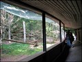 view gallery view gallery NE1.4 km NE1.4 km
|  Scavenger Birds Aviary, Neuschönau, Germany Scavenger Birds Aviary, Neuschönau, Germany
in Aviaries Aviary in forest ZOO above Neuschönau. posted by: Dáin & Olík location: Bayern, Germany date approved: 05/13/2011 last visited: 09/15/2016 |
 view gallery view galleryNE2.1 km | Owl Aviary, Neuschönau, Germany in Aviaries Aviary in forest ZOO above Neuschönau. posted by: Dáin & Olík location: Bayern, Germany date approved: 05/13/2011 last visited: 09/15/2016 |
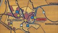 view gallery view gallery N4.5 km N4.5 km
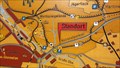
|  'You Are Here' Map in at Lusenstrasse, GER 'You Are Here' Map in at Lusenstrasse, GER
in 'You Are Here' Maps One of many splendid maps in Nationalpark Bayerischer Wald. posted by: walden2 location: Bayern, Germany date approved: 12/21/2011 last visited: 09/21/2016 |
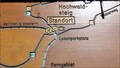 view gallery view galleryN5.1 km | 'You Are Here' Map at Lusenparkplatz, GER in 'You Are Here' Maps One of many splendid maps in Nationalpark Bayerischer Wald. posted by: walden2 location: Bayern, Germany date approved: 12/21/2011 last visited: 09/21/2016 |
 view gallery view galleryN5.6 km | 'You Are Here' Map at Pavillon Bohmweg, GER in 'You Are Here' Maps One of many splendid wood maps in Nationalpark Bayerischer Wald. posted by: walden2 location: Bayern, Germany date approved: 12/21/2011 last visited: 09/21/2016 |
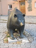 view gallery view gallery SW6.1 km SW6.1 km
|  Börsenbär - Grafenau, Bavaria, Germany Börsenbär - Grafenau, Bavaria, Germany
in Bear Statues Der Börsenbär, von Bildhauer Reinhard Dachlauer, in Grafenau. posted by: lumbricus location: Bayern, Germany date approved: 12/26/2020 last visited: never |
 view gallery view galleryNE6.4 km |  Lusen (1373m) - Bayerischer Wald, Germany Lusen (1373m) - Bayerischer Wald, Germany
in Mountain Summits Der Lusen - Luzný posted by: Waupe location: Bayern, Germany date approved: 01/06/2011 last visited: 09/21/2016 |
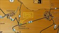
 view gallery view gallery NW7.9 km NW7.9 km
| 'You Are Here' Map at Parkplatz Trossel, GER in 'You Are Here' Maps One of many splendid maps in Nationalpark Bayerischer Wald. posted by: walden2 location: Bayern, Germany date approved: 12/21/2011 last visited: never |
 view gallery view gallery SE8.9 km SE8.9 km
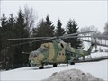
|  Russischer Kampfhubschrauber - Freyung, Lk Freyung-Grafenau, Bayern, D Russischer Kampfhubschrauber - Freyung, Lk Freyung-Grafenau, Bayern, D
in Static Aircraft Displays Russischer Kamphubschrauber Mil Mi-24 vor dem Max Fuchs Outdoor Laden. --- Russian attack helicopter Mil Ni-24 infront of the Max Fuchs Outdoor Shop. posted by: lumbricus location: Bayern, Germany date approved: 03/23/2012 last visited: 09/03/2016 |
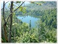 view gallery view galleryNW11.3 km |  Rachelsee, Bayern, DE Rachelsee, Bayern, DE
in Natural Lakes Rachelsee (Rachel Lake) is one of the eight glacial lakes in the Šumava mountains (The Bavarian and Bohemian Forest). Rachelsee is the third smallest tarn of this mountain range. posted by: Ursus PiPa location: Bayern, Germany date approved: 03/20/2013 last visited: 04/21/2018 |
 view gallery view gallery W11.4 km W11.4 km
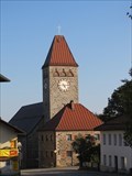
|  Katholische Pfarrkirche Maria Hilfe der Christen - Klingenbrunn, Bavaria, Germany Katholische Pfarrkirche Maria Hilfe der Christen - Klingenbrunn, Bavaria, Germany
in Roman Catholic Churches Katholische Pfarrkirche Maria Hilfe der Christen in Klingenbrunn, nähe Spiegelau. posted by: lumbricus location: Bayern, Germany date approved: 12/17/2020 last visited: never |
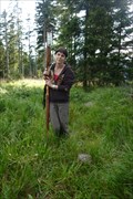
 view gallery view galleryNE11.6 km |  TP Siebensteinkopf - Bayern TP Siebensteinkopf - Bayern
in German Trigonometric Points TP on the top of Siebensteinkopf in the Bayerischer Wald. posted by: Ursus PiPa location: Bayern, Germany date approved: 04/11/2012 last visited: never |
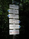
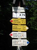 view gallery view galleryNE11.7 km |  Turisticky ukazatel "U pramene Vltavy" - Kvilda, Czech Republic Turisticky ukazatel "U pramene Vltavy" - Kvilda, Czech Republic
in Direction and Distance Arrows CZ: Turisticky ukazetel "U pramene Vltavy" EN: Direction and distance arrows "Near Vltava spring" posted by: honza.h location: Jihočeský kraj, Czechia date approved: 04/06/2013 last visited: 05/24/2015 |
 view gallery view galleryNW11.7 km | Grosser Rachel (1453m) - Bayerischer Wald, Germany in Mountain Summits Der Grosser Rachel (1453 m) - Velký Roklan posted by: Waupe location: Bayern, Germany date approved: 01/06/2011 last visited: 04/21/2018 |
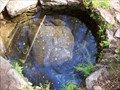 view gallery view galleryNE11.9 km |  Pramen Vltavy /// Moldau spring Pramen Vltavy /// Moldau spring
in Natural Springs Pramen Vltavy /// Moldau spring posted by: Ursus PiPa location: Jihočeský kraj, Czechia date approved: 07/29/2011 last visited: 02/26/2023 |
 view gallery view galleryNE11.9 km | Turisticky ukazatel "Pramen Vltavy" - Kvilda, Czech Republic in Direction and Distance Arrows CZ: Turisticky ukazetel "Pramen Vltavy" EN: Direction and distance arrows "Vltava spring" posted by: honza.h location: Jihočeský kraj, Czechia date approved: 04/05/2013 last visited: 05/24/2015 |
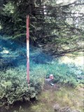 view gallery view galleryNE11.9 km |  TB 3911-10 Cerná hora TB 3911-10 Cerná hora
in Czech Geodetic Points Trigonometrický bod na vrcholu šumavské tisícovky Cerná hora /// Geodetic point on the top of Cerná hora posted by: Ursus PiPa location: Plzeňský kraj, Czechia date approved: 08/22/2011 last visited: never |
 view gallery view galleryNE12.9 km | TB 3911-11 Poštovní hora in Czech Geodetic Points Trigonometrický bod na vrcholu hory Stráž. /// Geodetic point on the top of Stráž. posted by: Ursus PiPa location: Jihočeský kraj, Czechia date approved: 07/28/2011 last visited: 09/25/2011 |
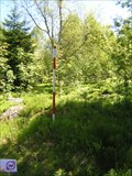 view gallery view galleryNE13 km | TB 3906-22 U kostela in Czech Geodetic Points Trigonometrický bod u Knížecích Plání na Šumave posted by: pavlikVB location: Jihočeský kraj, Czechia date approved: 06/16/2010 last visited: 08/26/2010 |
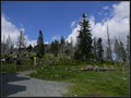
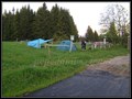 view gallery view galleryNE13.4 km |  Bucina camp Bucina camp
in Free Campsites Bucina camp posted by: Waupe location: Jihočeský kraj, Czechia date approved: 01/05/2011 last visited: 09/28/2011 |
 view gallery view galleryNE13.4 km | BTP 3168 Kvilda - Bucina in Czech Geodetic Points Bod 2.rádu základního tíhového bodového pole posted by: pavlikVB location: Jihočeský kraj, Czechia date approved: 06/16/2010 last visited: 08/11/2011 |
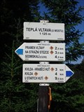 view gallery view galleryNE13.4 km | Turisticky ukazatel "Tepla Vltava (u mostu)" - Kvilda, Czech Republic in Direction and Distance Arrows CZ: Turisticky ukazetel "Tepla Vltava (u mostu)" EN: Direction and distance arrows "Tepla Vltava (at the bridge)" posted by: honza.h location: Jihočeský kraj, Czechia date approved: 04/05/2013 last visited: 05/24/2015 |
 view gallery view galleryN13.7 km | TB 3911-6 Sedmikámen in Czech Geodetic Points Trigonometrický bod na vrcholovém skalisku tisícovky Certuv vrch (1 244 m ) /// Geodetic point on the top of the mountain named Certuv vrch ( 1 244 m) posted by: Ursus PiPa location: Plzeňský kraj, Czechia date approved: 05/26/2011 last visited: 09/25/2011 |
|