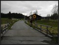
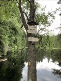
 view gallery view gallery SE3.7 km SE3.7 km
|   Nové Údolí/ Neuthal Nové Údolí/ Neuthal
in Ghost Towns Nové Údolí posted by:  Waupe Waupe location: Jihočeský kraj, Czechia date approved: 10/28/2010 last visited: 05/16/2016 |
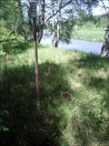
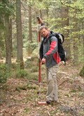 view gallery view gallerySE5.3 km |  TB 3903-14 Spicak TB 3903-14 Spicak
in Czech Geodetic Points Trigonometrický bod na Šumavské tisícovce posted by:  pavlikVB pavlikVB location: Jihočeský kraj, Czechia date approved: 05/11/2009 last visited: 08/19/2011 |
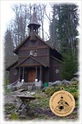 view gallery view gallery NE6 km NE6 km
|  No. 503, Stožecká kaple, Šumava, CZ No. 503, Stožecká kaple, Šumava, CZ
in Tourist Stamps Photos Turistická známka zobrazuje drevenou poutní kapli Panny Marie na úbocí hory Stožec. /// Tourist stamp shows the Chapel of the Virgin Mary, the wooden pilgrimage chapel posted by: Ursus PiPa location: Jihočeský kraj, Czechia date approved: 11/12/2012 last visited: 09/25/2020 |
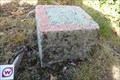
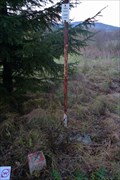 view gallery view galleryNE6.8 km | TB 3902-15 Pod lesem in Czech Geodetic Points Trigonometrický bod západne od Volar (Šumava) posted by: pavlikVB location: Jihočeský kraj, Czechia date approved: 11/05/2012 last visited: never |
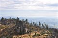 view gallery view gallerySE7.2 km |  Hochstein - Freyung-Grafenau - Bayern - Germany Hochstein - Freyung-Grafenau - Bayern - Germany
in Scenic Overlooks The "Hochstein" (alt. 1333m) is a cluster of granite blocks on the highest spot of the mountain "Dreisessel" in Bavaria.
Der Hochstein (1333 m ü. NN) ist eine Granitfelsgruppe an der höchsten Stelle des Dreisesselbergs im Bayerischen Wald posted by: McGreifer location: Bayern, Germany date approved: 02/22/2016 last visited: never |
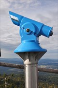 view gallery view gallerySE7.2 km |  BINO on the top of the "Hochstein"-BINO auf dem Hochstein BINO on the top of the "Hochstein"-BINO auf dem Hochstein
in Coin-Op Binoculars Awesome view from the top of the mountain "Hochstein" in the National Park "Bayrischer Wald". posted by: McGreifer location: Bayern, Germany date approved: 10/06/2015 last visited: 03/04/2018 |
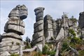 view gallery view gallerySE7.4 km |  Wollsackverwitterung am Hochstein - Bayern - Germany Wollsackverwitterung am Hochstein - Bayern - Germany
in Places of Geologic Significance Impressive rock formation next to the walking track towards the "Hochstein"
Beeindruckende Felsformation neben dem Fußweg zum Hochstein posted by: McGreifer location: Bayern, Germany date approved: 02/22/2016 last visited: never |
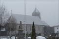 view gallery view gallery S8 km S8 km
|  Katholische Pfarrkirche St. Sigismund - Altreichenau, Bavaria, Germany Katholische Pfarrkirche St. Sigismund - Altreichenau, Bavaria, Germany
in Roman Catholic Churches Katholische Pfarrkirche St. Sigismund in Altreichenau, Bayern. posted by: lumbricus location: Bayern, Germany date approved: 07/09/2021 last visited: never |
 view gallery view galleryNE8.2 km | TB 3902-16 Pod transfomátorem in Czech Geodetic Points Trigonometrický bod v nive Teplé Vltavy /// Geodetic point on the flood-plain of the Moldau river. posted by: Ursus PiPa location: Jihočeský kraj, Czechia date approved: 06/21/2011 last visited: never |
 view gallery view galleryNE8.4 km |  Dobrá (lávka) Dobrá (lávka)
in Direction and Distance Arrows Rozcestník u mostku pres Teplou Vltavu. Nadmorská výška je 744m. posted by: prokestom location: Jihočeský kraj, Czechia date approved: 09/18/2023 last visited: never |
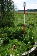
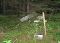
 view gallery view gallerySE8.7 km | TB 3904-1 V reservaci in Czech Geodetic Points Trigonometrický bod na vrchu Vysoký hreben posted by: pavlikVB location: Jihočeský kraj, Czechia date approved: 05/06/2009 last visited: never |
 view gallery view gallery N9.2 km N9.2 km
| BTP 3164 Horní Vltavice - Lenora in Czech Geodetic Points Bod 1.rádu základního tíhového bodového pole. posted by: pavlikVB location: Jihočeský kraj, Czechia date approved: 06/08/2009 last visited: 05/22/2014 |
 view gallery view gallery E9.3 km E9.3 km
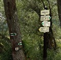
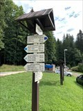
| JELENÍ VRCHY 885 m, Czech republic in Direction and Distance Arrows Turistický rozcestník u parkovište na Jelením vrchu. Tourist direction and distance arrows at the parking lot on Jelení vrch. posted by: davidb11 location: Jihočeský kraj, Czechia date approved: 08/05/2022 last visited: never |
 view gallery view galleryNE9.5 km | TB 3902-12 Na rozcestí in Czech Geodetic Points Trigonometrický bod na odbocce ke kempu Soumarský most posted by: pavlikVB location: Jihočeský kraj, Czechia date approved: 06/08/2009 last visited: never |
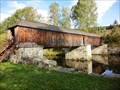 view gallery view galleryN9.5 km |  Rechle u Lenory - Czech Republic Rechle u Lenory - Czech Republic
in Satellite Imagery Oddities The roofed wooden bridge [CZ: Rechle] posted by: ToRo61 location: Jihočeský kraj, Czechia date approved: 01/27/2017 last visited: 10/08/2022 |
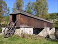 view gallery view galleryN9.5 km |  Rechle u Lenory / Lenora-covered bridge Rechle u Lenory / Lenora-covered bridge
in Covered Bridges Krytý drevený most pres Vltavu na konci Lenory smerem na Volary.
EN:Covered bridge across Moldau river in Lenora. posted by: bartusko location: Jihočeský kraj, Czechia date approved: 05/11/2010 last visited: 10/08/2022 |
 view gallery view galleryN9.5 km | No. 112, Lenora-Vltava, CZ in Tourist Stamps Photos Lenora Town, Vltava river. posted by: ToRo61 location: Jihočeský kraj, Czechia date approved: 10/31/2013 last visited: 10/08/2022 |
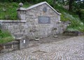
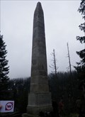
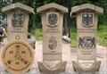 view gallery view gallerySE10 km | No. 1971, Cesko-Nemecko-Rakouské Trojmezí, CZ in Tourist Stamps Photos Hranicní kámen v míste, kde se setkávají hranice trí zemí - Ceské republiky, Nemecka a Rakouska. /// Border stone on the tripoint of the Czech Republic (foreground), Austria and Germany. posted by: pavlikVB location: Jihočeský kraj, Czechia date approved: 05/01/2014 last visited: 08/21/2020 |
 view gallery view gallerySE10 km |  Trojmezí/ Three Borders (tripont) Trojmezí/ Three Borders (tripont)
in European Historic Survey Stones, Monuments and Benchmarks Trojmezí (Dreieckmark). Místo, kde se setkávají hranice CR, Rakouska a SRN/ Three Borders (Dreieckmark). The place where the borders meet Republic, Austria and Germany. posted by: Waupe location: Jihočeský kraj, Czechia date approved: 01/28/2011 last visited: 08/21/2020 |
 view gallery view gallerySE10 km |  Trojmezí / Dreickenmark, Šumava - CZ, D, A Trojmezí / Dreickenmark, Šumava - CZ, D, A
in Tripoints and Multipoints Hranicní kámen v míste, kde se setkávají hranice trí zemí - Ceské republiky, Nemecka a Rakouska. /// Border stone on the tripoint of the Czech Republic (foreground), Austria and Germany. posted by: Ursus PiPa location: Jihočeský kraj, Czechia date approved: 03/12/2012 last visited: 08/21/2020 |
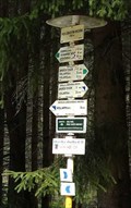 view gallery view galleryNE10 km | Pod Lískovým vrchem - 755m in Direction and Distance Arrows Rozcestník stojí západne od Volar, v nadmorské výšce 755m. posted by: prokestom location: Jihočeský kraj, Czechia date approved: 09/18/2023 last visited: never |
 view gallery view galleryE10.1 km | JELENÍ JEZÍRKO 950 m, Czech republic in Direction and Distance Arrows Turistický rozcestník u Jeleního jezírka. Tourist direction and distance arrows next to Jelení lake. posted by: davidb11 location: Jihočeský kraj, Czechia date approved: 08/05/2022 last visited: never |
 view gallery view galleryE10.1 km | TB 4023-8 U Chlumskeho mostu in Czech Geodetic Points Trigonometrický bod v I.zone NP Šumava posted by: pavlikVB location: Jihočeský kraj, Czechia date approved: 05/28/2017 last visited: never |
 view gallery view galleryN10.5 km | TB 3907-5 Orlov in Czech Geodetic Points Trigonometrický bod na Šumave posted by: pavlikVB location: Jihočeský kraj, Czechia date approved: 11/04/2012 last visited: never |
 view gallery view gallerySE10.5 km | TB 3904-2 Stifteruv pomnik in Czech Geodetic Points Trigonometrický bod nad Plešným jezerem posted by: pavlikVB location: Jihočeský kraj, Czechia date approved: 05/23/2010 last visited: 07/17/2016 |
|