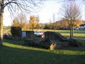
 view gallery view gallery W1 km W1 km
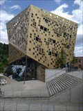
|   Forum Gold und Silber, Schwäbisch Gmünd, Baden-Württemberg, Germany Forum Gold und Silber, Schwäbisch Gmünd, Baden-Württemberg, Germany
in Odd-Shaped Buildings Ein Gebäude mit außergewöhnlicher Fassade ---- A building with an extraordinary façade posted by:  Windego1 Windego1 location: Baden-Württemberg, Germany date approved: 07/18/2023 last visited: 07/17/2023 |
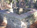
 view gallery view gallery SW2.9 km SW2.9 km
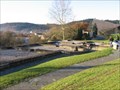
|  Kastellbad Schirenhof Kastellbad Schirenhof
in Ancient Roman Civilization Excavated remains of a Roman bath in the southwest German city of Schwäbisch Gmund. posted by: RakeInTheCache location: Baden-Württemberg, Germany date approved: 11/19/2006 last visited: 05/17/2014 |
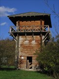 view gallery view galleryW7.2 km | Lorch Roman Watchtower Reconstruction in Ancient Roman Civilization Reconstructed wooden Roman watchtower along the Upper Germanic Limes border near the Southwest German village of Lorch. posted by: RakeInTheCache location: Baden-Württemberg, Germany date approved: 11/19/2006 last visited: 07/17/2023 |
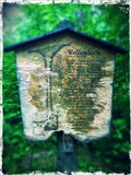
 view gallery view galleryW7.4 km |  347 Meter Kloster Lorch, Lorch, Baden-Württemberg, Germany 347 Meter Kloster Lorch, Lorch, Baden-Württemberg, Germany
in Elevation Signs Schild mit Höhenangabe u. UTM-Koordinaten am Kloster Lorch ---- Sign with altitude and UTM coordinates at Lorch Monastry posted by: Windego1 location: Baden-Württemberg, Germany date approved: 07/18/2023 last visited: 07/17/2023 |
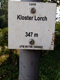 view gallery view galleryW7.4 km |  UTM: U32 551756/5405422, Kloster Lorch, Lorch, Germany UTM: U32 551756/5405422, Kloster Lorch, Lorch, Germany
in Permanent Geographic Coordinates Schild mit Höhenangabe am Kloster Lorch zeigt auch die UTM Koordinaten ---- Elevation sign at the Monastry of Lorch showing also UTM Coordinates posted by: Windego1 location: Baden-Württemberg, Germany date approved: 07/18/2023 last visited: 07/14/2023 |
 view gallery view galleryW8.4 km | Limes Germanicus - WP 12/11 in Ancient Roman Civilization Reconstructed remains of a Roman watchtower along the Upper Germanic Limes border near the Southwest German village of Lorch. posted by: RakeInTheCache location: Baden-Württemberg, Germany date approved: 11/19/2006 last visited: never |
 view gallery view galleryW8.5 km | Kohortenkastell Lorch - Oriaplatz in Ancient Roman Civilization The town of Lorch is built on the site of an ancient Roman fort. posted by: RakeInTheCache location: Baden-Württemberg, Germany date approved: 11/19/2006 last visited: 08/23/2015 |
 view gallery view gallery E8.9 km E8.9 km
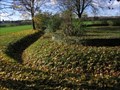
| Kohorten-Kastell Böbingen im Remstal in Ancient Roman Civilization The remains of a Roman fort in the southwest German town of Böbingen. posted by: RakeInTheCache location: Baden-Württemberg, Germany date approved: 11/19/2006 last visited: never |
 SW9.3 km |  Burg Hohenstaufen Burg Hohenstaufen
in Castles A waymark for European history buffs, this is the site of the anscestral fortress of the Hohenstaufen dynasty which ruled as emperors of the Holy Roman Empire of the German Nation in the 12th/13th centuries. posted by: RakeInTheCache location: Baden-Württemberg, Germany date approved: 04/18/2006 last visited: 05/04/2014 |
 view gallery view gallery NE9.5 km NE9.5 km
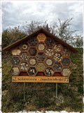
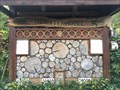
|  Insektenhotel Horner Hütte bei Horn, Ostalbkreis Insektenhotel Horner Hütte bei Horn, Ostalbkreis
in Insect Hotels Ein Insektenhotel in der Nähe der Horner Hütte bei Horn im Ostalbkreis. posted by: ede-v location: Baden-Württemberg, Germany date approved: 10/22/2017 last visited: 10/23/2017 |
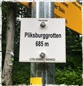 view gallery view galleryE10.8 km | 685m - Pliksburggrotten, Heubach, BW, Germany in Elevation Signs A small sign located above Heubach, which indicates an elevation of 685 meters above sea level. posted by: Biglailo location: Baden-Württemberg, Germany date approved: 08/13/2017 last visited: never |
 view gallery view galleryE10.9 km | Insect Hotel Schweizer - Mögglingen, Germany in Insect Hotels Insect hotel near Mögglingen. posted by: Biglailo location: Baden-Württemberg, Germany date approved: 10/22/2017 last visited: never |
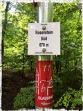 view gallery view galleryE11.1 km | 670m - Rosenstein Süd, Heubach, BW, Germany in Elevation Signs A small sign located above Heubach, which indicates an elevation of 670 meters above sea level. posted by: Biglailo location: Baden-Württemberg, Germany date approved: 08/13/2017 last visited: never |
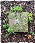 view gallery view galleryE11.4 km |  TP Große Scheuer - Heidenheim, BW, Germany TP Große Scheuer - Heidenheim, BW, Germany
in German Trigonometric Points Trigonometrischer Punkt ‚Große Scheuer‘ /
Trigonometric Point ‚Große Scheuer‘ posted by: Biglailo location: Baden-Württemberg, Germany date approved: 08/13/2017 last visited: never |
 view gallery view gallery SE11.4 km SE11.4 km
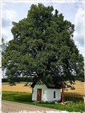
|  Kitzinger Kapelle - Bartholomä, BW, Germany Kitzinger Kapelle - Bartholomä, BW, Germany
in Waychapels Kitzinger Kapelle in der Nähe von Bartholomä / Kitzinger Kapelle near Bartolomä posted by: Biglailo location: Baden-Württemberg, Germany date approved: 08/07/2017 last visited: never |
 view gallery view gallery NW13.7 km NW13.7 km
| Limes Germanicus - Göckelersturm - WP 9/134 in Ancient Roman Civilization Reconstructed remains of a roman watchtower along the Upper Germanic Limes border near the Southwest German village of Welzheim. posted by: RakeInTheCache location: Baden-Württemberg, Germany date approved: 11/19/2006 last visited: 10/12/2011 |
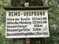 view gallery view galleryE14 km | Höhenmarke Rems-Ursprung, Essingen bei Aalen, Germany - 551 Meter in Elevation Signs Höhenmarke bei Essingen / in der Nähe von Aalen / Ostalbkreis / Germany posted by: ede-v location: Baden-Württemberg, Germany date approved: 09/20/2017 last visited: 10/03/2017 |
 view gallery view galleryNW14.2 km | Limes Germanicus - Welzheim Ostkastell in Ancient Roman Civilization Welzheim belonged to the most important garrisons of the Upper-Germanic Limes. posted by: RakeInTheCache location: Baden-Württemberg, Germany date approved: 11/19/2006 last visited: 05/17/2014 |
 view gallery view galleryNW15.6 km | Limes Germanicus - Fortlet "Rötelsee" - WP 9/128 in Ancient Roman Civilization Small Roman fort along the Upper Germanic Limes border near the Southwest German village of Welzheim. posted by: RakeInTheCache location: Baden-Württemberg, Germany date approved: 11/18/2006 last visited: 05/17/2014 |
 view gallery view gallery S18.7 km S18.7 km
| Insektenhotel bei Schlat, am Wasserberg, Landkreis Göppingen in Insect Hotels Ein Insektenhotel bei Schlat am Wasserberg im Landkreis Göppingen. posted by: ede-v location: Baden-Württemberg, Germany date approved: 09/16/2017 last visited: never |
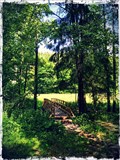 view gallery view galleryNE20.4 km |  Holzbrücke - Rotbachtal, Abtsgmünd Holzbrücke - Rotbachtal, Abtsgmünd
in Hiking Path Footbridges Holzbrücke zum Überqueren der Rot im Rotbachtal bei Abtsgmünd. posted by: Biglailo location: Baden-Württemberg, Germany date approved: 06/18/2017 last visited: never |
 view gallery view galleryE20.6 km |  Doline Wollenloch, Oberkochen Doline Wollenloch, Oberkochen
in Natural Sinkholes The 'Wollenloch' is one of the deepest sinkholes of the 'Swabian Jura'. posted by: Biglailo location: Baden-Württemberg, Germany date approved: 05/20/2017 last visited: never |
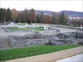 view gallery view galleryE20.8 km | Aalen - Kastell und Limesmuseum in Ancient Roman Civilization On this site was the largest Roman cavalry fort north of the Alps and was built around 160 A.D. posted by: RakeInTheCache location: Baden-Württemberg, Germany date approved: 11/19/2006 last visited: 05/07/2017 |
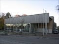 view gallery view galleryE20.8 km |  Limesmuseum Aalen Limesmuseum Aalen
in History Museums This museum in the town of Aalen in southwest Germany is dedicated to the history of the Roman limes which crossed this area and the preservation of artifacts from that time. posted by: RakeInTheCache location: Baden-Württemberg, Germany date approved: 11/19/2006 last visited: 05/07/2017 |
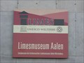 view gallery view galleryE20.8 km |  Frontiers of the Roman Empire Frontiers of the Roman Empire
in World Heritage Sites In 2005, Unesco added the German limes to the pre-existing site called Hadrian's Wall and renamed it. This location marks the Limes museum of Aalen, a town in southwest Germany located along the German limes. posted by: RakeInTheCache location: Baden-Württemberg, Germany date approved: 11/19/2006 last visited: 05/07/2017 |
|