 view gallery view gallery N3.4 km N3.4 km
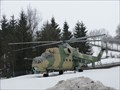
|   Russischer Kampfhubschrauber - Freyung, Lk Freyung-Grafenau, Bayern, D Russischer Kampfhubschrauber - Freyung, Lk Freyung-Grafenau, Bayern, D
in Static Aircraft Displays Russischer Kamphubschrauber Mil Mi-24 vor dem Max Fuchs Outdoor Laden. --- Russian attack helicopter Mil Ni-24 infront of the Max Fuchs Outdoor Shop. posted by:  lumbricus lumbricus location: Bayern, Germany date approved: 03/23/2012 last visited: 09/03/2016 |
 view gallery view gallery SE8.2 km SE8.2 km
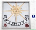
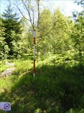
|  Geiermühle SUNDIAL, Waldkirchen, Bavaria, Germany Geiermühle SUNDIAL, Waldkirchen, Bavaria, Germany
in Sundials Sundial on the Geiermühle (watermill called Geiermühle) posted by: ChickenRaider location: Bayern, Germany date approved: 04/05/2010 last visited: never |
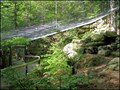
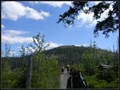
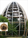 view gallery view galleryN11.4 km |  Nr. 517, Neuchönau - Baumwipfelpfad - Nationalpark - Bayerischer Wald, DE Nr. 517, Neuchönau - Baumwipfelpfad - Nationalpark - Bayerischer Wald, DE
in Tourist Stamps Photos 44m vysoká vyhlídková vež / 44m high look out tower in Neuchenau, GER posted by: Arogant location: Bayern, Germany date approved: 12/15/2011 last visited: 09/15/2016 |
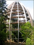 view gallery view galleryN11.4 km |  "Tree Top Walk" Tower, Neuschönau, Germany "Tree Top Walk" Tower, Neuschönau, Germany
in Look-Out Towers Great new look out tower in National Park Bavarian Forest. posted by:  Dáin & Olík Dáin & Olík location: Bayern, Germany date approved: 05/10/2011 last visited: 10/25/2017 |
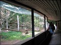 view gallery view galleryN11.9 km |  Scavenger Birds Aviary, Neuschönau, Germany Scavenger Birds Aviary, Neuschönau, Germany
in Aviaries Aviary in forest ZOO above Neuschönau. posted by: Dáin & Olík location: Bayern, Germany date approved: 05/13/2011 last visited: 09/15/2016 |
 view gallery view galleryN12.1 km | Owl Aviary, Neuschönau, Germany in Aviaries Aviary in forest ZOO above Neuschönau. posted by: Dáin & Olík location: Bayern, Germany date approved: 05/13/2011 last visited: 09/15/2016 |
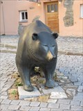 view gallery view gallery NW12.6 km NW12.6 km
|  Börsenbär - Grafenau, Bavaria, Germany Börsenbär - Grafenau, Bavaria, Germany
in Bear Statues Der Börsenbär, von Bildhauer Reinhard Dachlauer, in Grafenau. posted by: lumbricus location: Bayern, Germany date approved: 12/26/2020 last visited: never |
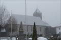 view gallery view gallery E14.2 km E14.2 km
|  Katholische Pfarrkirche St. Sigismund - Altreichenau, Bavaria, Germany Katholische Pfarrkirche St. Sigismund - Altreichenau, Bavaria, Germany
in Roman Catholic Churches Katholische Pfarrkirche St. Sigismund in Altreichenau, Bayern. posted by: lumbricus location: Bayern, Germany date approved: 07/09/2021 last visited: never |
 view gallery view galleryN15.4 km |  'You Are Here' Map at Lusenparkplatz, GER 'You Are Here' Map at Lusenparkplatz, GER
in 'You Are Here' Maps One of many splendid maps in Nationalpark Bayerischer Wald. posted by: walden2 location: Bayern, Germany date approved: 12/21/2011 last visited: 09/21/2016 |
 view gallery view galleryN15.6 km | 'You Are Here' Map in at Lusenstrasse, GER in 'You Are Here' Maps One of many splendid maps in Nationalpark Bayerischer Wald. posted by: walden2 location: Bayern, Germany date approved: 12/21/2011 last visited: 09/21/2016 |
 view gallery view galleryN16.1 km | 'You Are Here' Map at Pavillon Bohmweg, GER in 'You Are Here' Maps One of many splendid wood maps in Nationalpark Bayerischer Wald. posted by: walden2 location: Bayern, Germany date approved: 12/21/2011 last visited: 09/21/2016 |
 view gallery view galleryN16.3 km |  Lusen (1373m) - Bayerischer Wald, Germany Lusen (1373m) - Bayerischer Wald, Germany
in Mountain Summits Der Lusen - Luzný posted by: Waupe location: Bayern, Germany date approved: 01/06/2011 last visited: 09/21/2016 |
 view gallery view galleryN18.3 km |  TB 3906-22 U kostela TB 3906-22 U kostela
in Czech Geodetic Points Trigonometrický bod u Knížecích Plání na Šumave posted by: pavlikVB location: Jihočeský kraj, Czechia date approved: 06/16/2010 last visited: 08/26/2010 |
 view gallery view galleryNW18.5 km | 'You Are Here' Map at Parkplatz Trossel, GER in 'You Are Here' Maps One of many splendid maps in Nationalpark Bayerischer Wald. posted by: walden2 location: Bayern, Germany date approved: 12/21/2011 last visited: never |
 view gallery view galleryN19 km |  TP Siebensteinkopf - Bayern TP Siebensteinkopf - Bayern
in German Trigonometric Points TP on the top of Siebensteinkopf in the Bayerischer Wald. posted by: Ursus PiPa location: Bayern, Germany date approved: 04/11/2012 last visited: never |
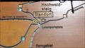
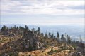 view gallery view galleryE19.2 km |  Hochstein - Freyung-Grafenau - Bayern - Germany Hochstein - Freyung-Grafenau - Bayern - Germany
in Scenic Overlooks The "Hochstein" (alt. 1333m) is a cluster of granite blocks on the highest spot of the mountain "Dreisessel" in Bavaria.
Der Hochstein (1333 m ü. NN) ist eine Granitfelsgruppe an der höchsten Stelle des Dreisesselbergs im Bayerischen Wald posted by: McGreifer location: Bayern, Germany date approved: 02/22/2016 last visited: never |
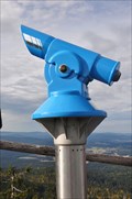 view gallery view galleryE19.2 km |  BINO on the top of the "Hochstein"-BINO auf dem Hochstein BINO on the top of the "Hochstein"-BINO auf dem Hochstein
in Coin-Op Binoculars Awesome view from the top of the mountain "Hochstein" in the National Park "Bayrischer Wald". posted by: McGreifer location: Bayern, Germany date approved: 10/06/2015 last visited: 03/04/2018 |
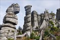 view gallery view galleryE19.2 km |  Wollsackverwitterung am Hochstein - Bayern - Germany Wollsackverwitterung am Hochstein - Bayern - Germany
in Places of Geologic Significance Impressive rock formation next to the walking track towards the "Hochstein"
Beeindruckende Felsformation neben dem Fußweg zum Hochstein posted by: McGreifer location: Bayern, Germany date approved: 02/22/2016 last visited: never |
 view gallery view galleryE19.2 km | TB 3903-14 Spicak in Czech Geodetic Points Trigonometrický bod na Šumavské tisícovce posted by: pavlikVB location: Jihočeský kraj, Czechia date approved: 05/11/2009 last visited: 08/19/2011 |
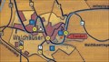
 view gallery view galleryE19.3 km |  Nové Údolí/ Neuthal Nové Údolí/ Neuthal
in Ghost Towns Nové Údolí posted by: Waupe location: Jihočeský kraj, Czechia date approved: 10/28/2010 last visited: 05/16/2016 |
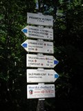
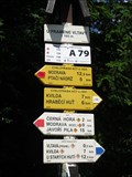 view gallery view galleryN19.6 km |  Turisticky ukazatel "U pramene Vltavy" - Kvilda, Czech Republic Turisticky ukazatel "U pramene Vltavy" - Kvilda, Czech Republic
in Direction and Distance Arrows CZ: Turisticky ukazetel "U pramene Vltavy" EN: Direction and distance arrows "Near Vltava spring" posted by: honza.h location: Jihočeský kraj, Czechia date approved: 04/06/2013 last visited: 05/24/2015 |
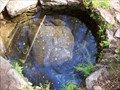 view gallery view galleryN20 km |  Pramen Vltavy /// Moldau spring Pramen Vltavy /// Moldau spring
in Natural Springs Pramen Vltavy /// Moldau spring posted by: Ursus PiPa location: Jihočeský kraj, Czechia date approved: 07/29/2011 last visited: 02/26/2023 |
 view gallery view galleryN20 km | Turisticky ukazatel "Pramen Vltavy" - Kvilda, Czech Republic in Direction and Distance Arrows CZ: Turisticky ukazetel "Pramen Vltavy" EN: Direction and distance arrows "Vltava spring" posted by: honza.h location: Jihočeský kraj, Czechia date approved: 04/05/2013 last visited: 05/24/2015 |
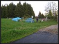 view gallery view galleryN20 km |  Bucina camp Bucina camp
in Free Campsites Bucina camp posted by: Waupe location: Jihočeský kraj, Czechia date approved: 01/05/2011 last visited: 09/28/2011 |
 view gallery view galleryN20 km | BTP 3168 Kvilda - Bucina in Czech Geodetic Points Bod 2.rádu základního tíhového bodového pole posted by: pavlikVB location: Jihočeský kraj, Czechia date approved: 06/16/2010 last visited: 08/11/2011 |
|