 view gallery view gallery NE9.7 km NE9.7 km
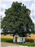
|   Kitzinger Kapelle - Bartholomä, BW, Germany Kitzinger Kapelle - Bartholomä, BW, Germany
in Waychapels Kitzinger Kapelle in der Nähe von Bartholomä / Kitzinger Kapelle near Bartolomä posted by:  Biglailo Biglailo location: Baden-Württemberg, Germany date approved: 08/07/2017 last visited: never |
  NW10.3 km NW10.3 km
|  Burg Hohenstaufen Burg Hohenstaufen
in Castles A waymark for European history buffs, this is the site of the anscestral fortress of the Hohenstaufen dynasty which ruled as emperors of the Holy Roman Empire of the German Nation in the 12th/13th centuries. posted by: RakeInTheCache location: Baden-Württemberg, Germany date approved: 04/18/2006 last visited: 05/04/2014 |
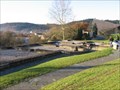 view gallery view galleryNW10.8 km |  Kastellbad Schirenhof Kastellbad Schirenhof
in Ancient Roman Civilization Excavated remains of a Roman bath in the southwest German city of Schwäbisch Gmund. posted by: RakeInTheCache location: Baden-Württemberg, Germany date approved: 11/19/2006 last visited: 05/17/2014 |
 view gallery view gallery SW11.1 km SW11.1 km
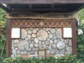
|  Insektenhotel bei Schlat, am Wasserberg, Landkreis Göppingen Insektenhotel bei Schlat, am Wasserberg, Landkreis Göppingen
in Insect Hotels Ein Insektenhotel bei Schlat am Wasserberg im Landkreis Göppingen. posted by: ede-v location: Baden-Württemberg, Germany date approved: 09/16/2017 last visited: never |
 view gallery view gallery N11.7 km N11.7 km
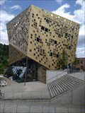
|  Forum Gold und Silber, Schwäbisch Gmünd, Baden-Württemberg, Germany Forum Gold und Silber, Schwäbisch Gmünd, Baden-Württemberg, Germany
in Odd-Shaped Buildings Ein Gebäude mit außergewöhnlicher Fassade ---- A building with an extraordinary façade posted by: Windego1 location: Baden-Württemberg, Germany date approved: 07/18/2023 last visited: 07/17/2023 |
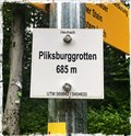 view gallery view galleryNE13 km |  685m - Pliksburggrotten, Heubach, BW, Germany 685m - Pliksburggrotten, Heubach, BW, Germany
in Elevation Signs A small sign located above Heubach, which indicates an elevation of 685 meters above sea level. posted by: Biglailo location: Baden-Württemberg, Germany date approved: 08/13/2017 last visited: never |
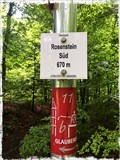 view gallery view galleryNE13.2 km | 670m - Rosenstein Süd, Heubach, BW, Germany in Elevation Signs A small sign located above Heubach, which indicates an elevation of 670 meters above sea level. posted by: Biglailo location: Baden-Württemberg, Germany date approved: 08/13/2017 last visited: never |
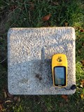
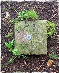 view gallery view galleryNE13.8 km |  TP Große Scheuer - Heidenheim, BW, Germany TP Große Scheuer - Heidenheim, BW, Germany
in German Trigonometric Points Trigonometrischer Punkt ‚Große Scheuer‘ /
Trigonometric Point ‚Große Scheuer‘ posted by: Biglailo location: Baden-Württemberg, Germany date approved: 08/13/2017 last visited: never |
 view gallery view galleryNE14.5 km | Kohorten-Kastell Böbingen im Remstal in Ancient Roman Civilization The remains of a Roman fort in the southwest German town of Böbingen. posted by: RakeInTheCache location: Baden-Württemberg, Germany date approved: 11/19/2006 last visited: never |
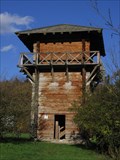 view gallery view galleryNW15 km | Lorch Roman Watchtower Reconstruction in Ancient Roman Civilization Reconstructed wooden Roman watchtower along the Upper Germanic Limes border near the Southwest German village of Lorch. posted by: RakeInTheCache location: Baden-Württemberg, Germany date approved: 11/19/2006 last visited: 07/17/2023 |
 view gallery view galleryNW15 km | 347 Meter Kloster Lorch, Lorch, Baden-Württemberg, Germany in Elevation Signs Schild mit Höhenangabe u. UTM-Koordinaten am Kloster Lorch ---- Sign with altitude and UTM coordinates at Lorch Monastry posted by: Windego1 location: Baden-Württemberg, Germany date approved: 07/18/2023 last visited: 07/17/2023 |
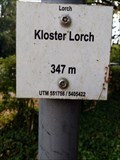 view gallery view galleryNW15 km |  UTM: U32 551756/5405422, Kloster Lorch, Lorch, Germany UTM: U32 551756/5405422, Kloster Lorch, Lorch, Germany
in Permanent Geographic Coordinates Schild mit Höhenangabe am Kloster Lorch zeigt auch die UTM Koordinaten ---- Elevation sign at the Monastry of Lorch showing also UTM Coordinates posted by: Windego1 location: Baden-Württemberg, Germany date approved: 07/18/2023 last visited: 07/14/2023 |
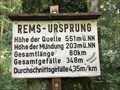 view gallery view galleryNE15.3 km | Höhenmarke Rems-Ursprung, Essingen bei Aalen, Germany - 551 Meter in Elevation Signs Höhenmarke bei Essingen / in der Nähe von Aalen / Ostalbkreis / Germany posted by: ede-v location: Baden-Württemberg, Germany date approved: 09/20/2017 last visited: 10/03/2017 |
 view gallery view galleryNW15.6 km | Kohortenkastell Lorch - Oriaplatz in Ancient Roman Civilization The town of Lorch is built on the site of an ancient Roman fort. posted by: RakeInTheCache location: Baden-Württemberg, Germany date approved: 11/19/2006 last visited: 08/23/2015 |
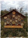 view gallery view galleryNE15.8 km | Insect Hotel Schweizer - Mögglingen, Germany in Insect Hotels Insect hotel near Mögglingen. posted by: Biglailo location: Baden-Württemberg, Germany date approved: 10/22/2017 last visited: never |
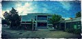 view gallery view gallery E16.4 km E16.4 km
|  Steinheim am Albuch, Germany Steinheim am Albuch, Germany
in City and Town Halls The town hall of Steinheim am Albuch. posted by: Biglailo location: Baden-Württemberg, Germany date approved: 06/27/2017 last visited: never |
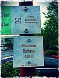 view gallery view galleryE16.4 km | 530m - Steinheim Rathaus, Steinheim am Albuch, Germany in Elevation Signs A small sign located in front of the townhall in Steinheim am Albuch, which indicates an elevation of 530 meters above sea level. posted by: Biglailo location: Baden-Württemberg, Germany date approved: 06/28/2017 last visited: never |
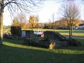
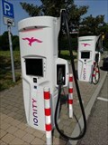
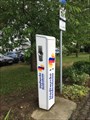 view gallery view galleryE16.4 km |  Ladesäule Steinheim - Steinheim am Albuch, BW, Germany Ladesäule Steinheim - Steinheim am Albuch, BW, Germany
in Electric Car Charging Stations Ladesäule auf dem Parkplatz vor dem Rathaus 'Steinheim am Albuch'. posted by: Biglailo location: Baden-Württemberg, Germany date approved: 07/12/2017 last visited: never |
 view gallery view galleryE16.4 km |  You are here - Steinheim am Albuch, BW, Germany You are here - Steinheim am Albuch, BW, Germany
in 'You Are Here' Maps 'You Are Here'-Map at the town hall of Steinheim am Albuch posted by: Biglailo location: Baden-Württemberg, Germany date approved: 07/02/2017 last visited: never |
 view gallery view galleryNW16.6 km | Limes Germanicus - WP 12/11 in Ancient Roman Civilization Reconstructed remains of a Roman watchtower along the Upper Germanic Limes border near the Southwest German village of Lorch. posted by: RakeInTheCache location: Baden-Württemberg, Germany date approved: 11/19/2006 last visited: never |
 view gallery view galleryE16.9 km | TP Burgstall, Heidenheim in German Trigonometric Points Trigonometrischer Punkt "Schmittenberg" /
Trigonometric Point “Schmittenberg“ posted by: Biglailo location: Baden-Württemberg, Germany date approved: 10/04/2015 last visited: never |
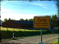 view gallery view galleryE17.2 km |  Zang - Königsbronn, Germany , BW Zang - Königsbronn, Germany , BW
in 'Z' Welcome Signs This is the village of 'Zang' in Germany, Baden-Württemberg. It's a village whos name starts with a 'Z'. posted by: Biglailo location: Baden-Württemberg, Germany date approved: 05/22/2017 last visited: 10/15/2017 |
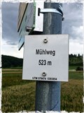 view gallery view galleryE17.5 km | 523m - Mühlweg, Steinheim am Albuch, BW, Germany in Elevation Signs A small sign located near Steinheim am Albuch, which indicates an elevation of 523 meters above sea level. posted by: Biglailo location: Baden-Württemberg, Germany date approved: 07/24/2017 last visited: never |
 view gallery view galleryN17.9 km | Insektenhotel Horner Hütte bei Horn, Ostalbkreis in Insect Hotels Ein Insektenhotel in der Nähe der Horner Hütte bei Horn im Ostalbkreis. posted by: ede-v location: Baden-Württemberg, Germany date approved: 10/22/2017 last visited: 10/23/2017 |
 view gallery view gallerySW18.5 km | IONITY Charging Stations - Raststätte Gruibingen, Germany, BW in Electric Car Charging Stations At the resting area 'Raststätte Gruibingen' at the motorway 'Autobahn A8' in Germany, Baden-Württemberg exist 6 car charging stations by 'IONITY'. posted by:  Tante.Hossi Tante.Hossi location: Baden-Württemberg, Germany date approved: 07/16/2020 last visited: never |
|