 view gallery view gallery N24.5 km N24.5 km
|   Navajo Web Camera - Redstone, MT Navajo Web Camera - Redstone, MT
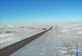
in Web Cameras This is one of 73 (as of January 2017) Road Weather Information System camera sites operated by the Montana Department of Transportation to aid motorists as they make their way across BIG SKY Country. posted by:  T0SHEA T0SHEA location: Montana date approved: 02/04/2017 last visited: never |
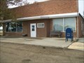
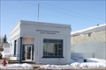 view gallery view galleryN24.5 km |  Flaxville, MT 59222 Flaxville, MT 59222
in U.S. Post Offices Tiny little building in rural town posted by: ZenPanda location: Montana date approved: 10/29/2014 last visited: 10/29/2014 |
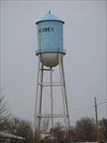
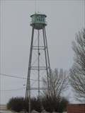 view gallery view galleryN24.6 km |  Flaxville, MT Water Tower Flaxville, MT Water Tower
in Water Towers Flaxville, MT: City Water Tower posted by:  The Yoyo Man The Yoyo Man location: Montana date approved: 12/06/2008 last visited: never |
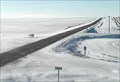
 view gallery view gallery SW32.2 km SW32.2 km
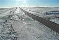
| McDonalds North Web Camera - Scobey, MT in Web Cameras This is one of 73 (as of January 2017) Road Weather Information System camera sites operated by the Montana Department of Transportation to aid motorists as they make their way across BIG SKY Country. posted by: T0SHEA location: Montana date approved: 02/02/2017 last visited: never |
 view gallery view gallerySW32.2 km | McDonalds South Web Camera - Scobey, MT in Web Cameras This is one of 73 (as of January 2017) Road Weather Information System camera sites operated by the Montana Department of Transportation to aid motorists as they make their way across BIG SKY Country. posted by: T0SHEA location: Montana date approved: 02/02/2017 last visited: never |
 view gallery view gallery NW32.8 km NW32.8 km
| Scobey, MT Water Tower in Water Towers Scobey, MT: City Water Tower
posted by: The Yoyo Man location: Montana date approved: 12/06/2008 last visited: never |
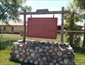
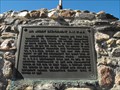 view gallery view galleryN50.4 km |  Big Muddy Detachment RNWMP/ Last Mounted Horse Patrol Big Muddy Detachment RNWMP/ Last Mounted Horse Patrol
in Saskatchewan Historical Markers Unfortunately this is located on private land that has a locked gate. I I was able to see this through a tour that is provided by Big Muddy Tours out of Coronach, Saskatchewan. posted by: Altima Voyageur location: Saskatchewan, Canada date approved: 09/30/2013 last visited: never |
 view gallery view galleryNW51.2 km |  Saskatchewan / Montana Border - Highway 13 (USA) / Highway 36 (Canada) Saskatchewan / Montana Border - Highway 13 (USA) / Highway 36 (Canada)
in Border Crossings a border crossing between the Canadian province of Saskatchewan and the US state of Montana located on highway 13 in Montana, USA. posted by: oiseau_ca location: Montana date approved: 09/04/2014 last visited: never |
 view gallery view gallery S53.9 km S53.9 km
|  Fort Peck Reservation, Assiniboine & Sioux - Montana, USA Fort Peck Reservation, Assiniboine & Sioux - Montana, USA
in Nations Within Nations Assiniboine & Sioux - Nakoda posted by: CerealBoxMonsters location: Montana date approved: 07/30/2009 last visited: 02/12/2013 |
 view gallery view galleryS53.9 km |  Fort Peck Indian Reservation - Poplar, MT Fort Peck Indian Reservation - Poplar, MT
in Montana Historical Markers A small sampling of history of the Assiniboines and Dakota tribes, and of Fort Peck Indian Reservation posted by: Bon Echo location: Montana date approved: 07/23/2018 last visited: never |
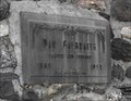 view gallery view galleryN57 km | Dan Galbraith in Saskatchewan Historical Markers This huge cairn was located by an building that was almost missed when I drove by! This is located in the small community of Big Beaver, Saskatchewan. posted by: Altima Voyageur location: Saskatchewan, Canada date approved: 09/29/2013 last visited: never |
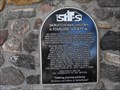 view gallery view galleryN57 km | Big Beaver, Schools that are History! in Saskatchewan Historical Markers This plaque is located on the Dan Galbraith cairn. It mentions all the country schools that were located around the community of Big Beaver. posted by: Altima Voyageur location: Saskatchewan, Canada date approved: 09/29/2013 last visited: never |
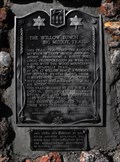 view gallery view galleryN60 km | The Willow Bunch - Big Muddy Trail in Saskatchewan Historical Markers This cain was erected by the South Country Buckaroos, 4H Horse Club in co-operation with the Saskatchewan Department of Natural Resources in the year 1967. posted by: Altima Voyageur location: Saskatchewan, Canada date approved: 09/22/2013 last visited: 07/21/2017 |
 view gallery view gallery E65.5 km E65.5 km
| Comertown Turn-Off West - Plentywood, MT in Web Cameras This is one of 73 (as of January 2017) Road Weather Information System cameras operated by the Montana Department of Transportation to aid motorists as they make their way across BIG SKY Country. posted by: T0SHEA location: Montana date approved: 01/12/2017 last visited: never |
 view gallery view gallery SE65.5 km SE65.5 km
|  Corps of Discovery II - Culbertson, Montana Corps of Discovery II - Culbertson, Montana
in U.S. Benchmarks Corps of Discovery II – Culbertson, MT, is a four-inch Lewis and Clark commemorative disk located at the Culbertson Museum. posted by: seventhings location: Montana date approved: 11/26/2005 last visited: 04/03/2006 |
 view gallery view galleryE65.5 km | Comertown Turn-Off East - Plentywood, MT in Web Cameras This is one of 73 (as of January 2017) Road Weather Information System cameras operated by the Montana Department of Transportation to aid motorists as they make their way across BIG SKY Country. posted by: T0SHEA location: Montana date approved: 01/12/2017 last visited: never |
 view gallery view galleryNW65.8 km | Coronach Horse in Saskatchewan Historical Markers Historical reference to a horse race in 1926. posted by: Altima Voyageur location: Alberta, Canada date approved: 09/22/2013 last visited: never |
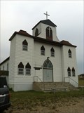 view gallery view gallerySE66.1 km |  First English Lutheran - Bainville, MT First English Lutheran - Bainville, MT
in Lutheran Churches First Lutheran Church in Bainville, MT. posted by: Islamorada location: Montana date approved: 06/07/2013 last visited: never |
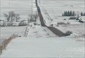
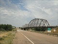 view gallery view gallerySW67.6 km |  LONGEST truss bridge in Montana - Wolf Point (Montana) USA LONGEST truss bridge in Montana - Wolf Point (Montana) USA
in Superlatives an abandoned truss bridge located on state highway 13 in the town of Wolf Point (Montana) USA posted by: oiseau_ca location: Montana date approved: 09/04/2014 last visited: 04/24/2023 |
 view gallery view gallerySW67.6 km |  The Lewis and Clark Bridge - Wolf Point (Montana) USA The Lewis and Clark Bridge - Wolf Point (Montana) USA
in Orphaned Bridges an abandoned truss bridge located on state highway 13 in the town of Wolf Point (Montana)USA posted by: oiseau_ca location: Montana date approved: 09/04/2014 last visited: 04/24/2023 |
 view gallery view gallerySW67.6 km |  The Lewis and Clark Bridge - Wolf Point (Montana) USA The Lewis and Clark Bridge - Wolf Point (Montana) USA
in Truss Bridges a truss bridge located on state highway 13 in the town of Wolf Point (Montana)USA posted by: oiseau_ca location: Montana date approved: 09/03/2014 last visited: 04/24/2023 |
 view gallery view gallerySW67.6 km |  The Lewis and Clark Bridge - Wolf Point, Montana The Lewis and Clark Bridge - Wolf Point, Montana
in U.S. National Register of Historic Places an abandoned truss bridge located on state highway 13 near the town of Wolf Point, Montana, USA posted by: oiseau_ca location: Montana date approved: 11/26/2014 last visited: 04/24/2023 |
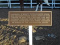
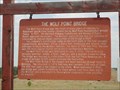 view gallery view gallerySW67.6 km | The Lewis and Clark Bridge - Wolf Point (Montana) USA in Montana Historical Markers a historical sign placed near an abandoned truss bridge located on state highway 13 in the town of Wolf Point (Montana) USA posted by: oiseau_ca location: Montana date approved: 09/03/2014 last visited: 04/24/2023 |
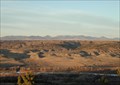
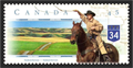 view gallery view galleryN76.1 km |  Big Muddy Badlands, SK, Canada Big Muddy Badlands, SK, Canada
in Philatelic Photographs This stamp shows the view from southbound highway 34 just before it descends into the Big Muddy Valley in southern Saskatchewan. posted by: hykesj location: Saskatchewan, Canada date approved: 04/03/2017 last visited: never |
 view gallery view galleryS89.6 km | Vida, Montana 59274 in U.S. Post Offices Post office in a very small town. posted by: NGComets location: Montana date approved: 11/01/2012 last visited: never |
|