 view gallery view gallery W11.9 km W11.9 km
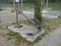
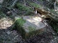
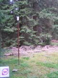
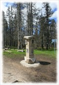
|   Kasten Anchor #1 Kasten Anchor #1
in Anchors Anchor on display in Kasten next to a ferry landing place. posted by:  llavids llavids location: Oberösterreich, Austria date approved: 08/15/2011 last visited: 08/28/2015 |
 view gallery view gallery NE14.6 km NE14.6 km
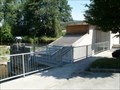
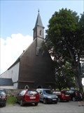
|  Stift Schlaegel - Schlaegl, OO, Austria Stift Schlaegel - Schlaegl, OO, Austria
in Hydroelectric Power Stations [EN]Small hydro power plant with interesting combination of Kaplan turbines and screw.
[DE]Kleinwasserkraftwerk mit interessante Kombination von Kaplan Turbinen und Schnecke. posted by: Arne1 location: Oberösterreich, Austria date approved: 07/16/2013 last visited: never |
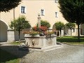 view gallery view galleryNE14.6 km |  Monastery Schlägl, Austria Monastery Schlägl, Austria
in Fountains Fountain with fish in the Upper Austria monastery Schlägl posted by: Arne1 location: Oberösterreich, Austria date approved: 07/15/2013 last visited: never |
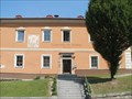 view gallery view galleryNE14.6 km |  Gemeindeamt Schlägl, Austria Gemeindeamt Schlägl, Austria
in Sundials Sundial on the wall of Authority in Schlägl near the abbey in Upper Austria. posted by: Arne1 location: Niederösterreich, Austria date approved: 07/16/2013 last visited: never |
 view gallery view gallery SW15.4 km SW15.4 km
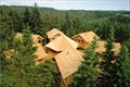
|  Treehouse Hotel Baumkronenweg - Kopfing, Austria Treehouse Hotel Baumkronenweg - Kopfing, Austria
in Treehouses Treehouse Hotel Baumkronenweg - Kopfing, Austria posted by: luzzi-reloaded location: Tirol, Austria date approved: 05/13/2012 last visited: 05/23/2014 |
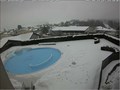 view gallery view galleryNE15.6 km |  Live Cam Hotel Almesberger - Oberösterreich / Austria Live Cam Hotel Almesberger - Oberösterreich / Austria
in Web Cameras Live Cam shows the swimming pool of the hotel posted by: Iris & Harry location: Oberösterreich, Austria date approved: 01/31/2017 last visited: never |
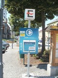 view gallery view galleryNE15.6 km |  Marktplatz in Aigen im Mühlkreis, Austria Marktplatz in Aigen im Mühlkreis, Austria
in Electric Car Charging Stations [DE] Ladestation auf dem Marktplatz in Aigen, OO
[EN] Electric charging station on Square in Aigen, Upper Austria posted by: Arne1 location: Oberösterreich, Austria date approved: 07/16/2013 last visited: never |
 view gallery view gallerySW15.9 km |  Baumkronenweg Kopfing, Öberösterreich - Austria Baumkronenweg Kopfing, Öberösterreich - Austria
in Official Local Tourism Attractions Baumkronenweg Kopfing, Öberösterreich - Austria posted by: luzzi-reloaded location: Oberösterreich, Austria date approved: 03/14/2011 last visited: 07/15/2011 |
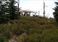
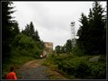
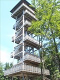 view gallery view galleryNE18.5 km |  Alpenblick, Ulrichsberg , Austria Alpenblick, Ulrichsberg , Austria
in Look-Out Towers Wooden look-out tower with a view of the Upper Austria. posted by: Arne1 location: Oberösterreich, Austria date approved: 07/17/2013 last visited: never |
 view gallery view gallery E19.6 km E19.6 km
|  TB 5321-3 U Horní Ureše TB 5321-3 U Horní Ureše
in Czech Geodetic Points Trigonometrický bod na státní hranici s AUT posted by: pavlikVB location: Jihočeský kraj, Czechia date approved: 06/05/2020 last visited: never |
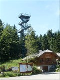 view gallery view galleryNE20.4 km | Moldaublick, Ulrichsberg , Austria in Look-Out Towers Metal look-out tower with a view of the Lipno Lake and surroundings on Czech territory. posted by: Arne1 location: Oberösterreich, Austria date approved: 07/17/2013 last visited: never |
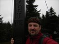 view gallery view gallery N22 km N22 km
|  Kríž na vrcholu hory Hochficht/The cross on the top mountain Hochficht Kríž na vrcholu hory Hochficht/The cross on the top mountain Hochficht
in Christian Crosses CZ: Kríž na vrcholu hory Hochficht
EN: The cross on the top mountain Hochficht posted by:  Waupe Waupe location: Oberösterreich, Austria date approved: 10/07/2010 last visited: 08/26/2014 |
 view gallery view galleryNE22 km | TB 4025-4 Kozi stran in Czech Geodetic Points Trigonometrický bod asi 350m od státní hranice s AUT posted by: pavlikVB location: Jihočeský kraj, Czechia date approved: 10/03/2010 last visited: never |
 view gallery view galleryN22 km | TB 4024-22 Smrcina in Czech Geodetic Points Trigonometrický bod na hore Smrcina posted by: pavlikVB location: Jihočeský kraj, Czechia date approved: 05/06/2009 last visited: 07/05/2013 |
 view gallery view galleryNE23 km | TB 4025-6 Kyselovsky les in Czech Geodetic Points Trigonometrický bod u Lipenské nádrže posted by: pavlikVB location: Jihočeský kraj, Czechia date approved: 07/17/2011 last visited: 07/20/2011 |
 view gallery view galleryNE23.5 km |  Kostel Kristova Utrpení - Svatý Tomáš, Czech Republic Kostel Kristova Utrpení - Svatý Tomáš, Czech Republic
in Roman Catholic Churches [CZ]: Gotický bývalý farní a poutní kostel v obci Svatý Tomáš byl postaven roku 1348 na príkaz Petra I. z Rožmberka.
[EN]: Gothic, former parish and pilgrimage church in village called Svatý Tomáš was built in 1348 by order of Peter I. of Rosenberg. posted by: alreadyhere location: Jihočeský kraj, Czechia date approved: 08/18/2014 last visited: 04/19/2019 |
 view gallery view galleryNE23.5 km |  Little Castle "Vítkuv Hrádek" Little Castle "Vítkuv Hrádek"
in Preserved Architectural Remnants and Ruins Little Castle "Vítkuv Hrádek" posted by: Waupe location: Jihočeský kraj, Czechia date approved: 01/04/2011 last visited: 07/25/2016 |
 view gallery view galleryN23.8 km | TB 3904-6 Studnicna in Czech Geodetic Points Trigonometrický bod na hore Studnicná posted by: pavlikVB location: Jihočeský kraj, Czechia date approved: 05/06/2009 last visited: 07/05/2013 |
 view gallery view galleryNE23.8 km | TB 4020-24 Svaty Tomas jv. in Czech Geodetic Points Trigonometrický bod nad Lipenskou nádrží posted by: pavlikVB location: Jihočeský kraj, Czechia date approved: 09/30/2014 last visited: never |
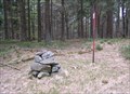
 view gallery view galleryN24.6 km |  Trojmezí/ Three Borders (tripont) Trojmezí/ Three Borders (tripont)
in European Historic Survey Stones, Monuments and Benchmarks Trojmezí (Dreieckmark). Místo, kde se setkávají hranice CR, Rakouska a SRN/ Three Borders (Dreieckmark). The place where the borders meet Republic, Austria and Germany. posted by: Waupe location: Jihočeský kraj, Czechia date approved: 01/28/2011 last visited: 08/21/2020 |
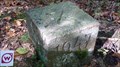
 view gallery view galleryN24.6 km |  Trojmezí / Dreickenmark, Šumava - CZ, D, A Trojmezí / Dreickenmark, Šumava - CZ, D, A
in Tripoints and Multipoints Hranicní kámen v míste, kde se setkávají hranice trí zemí - Ceské republiky, Nemecka a Rakouska. /// Border stone on the tripoint of the Czech Republic (foreground), Austria and Germany. posted by: Ursus PiPa location: Jihočeský kraj, Czechia date approved: 03/12/2012 last visited: 08/21/2020 |
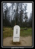
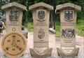 view gallery view galleryN24.6 km |  No. 1971, Cesko-Nemecko-Rakouské Trojmezí, CZ No. 1971, Cesko-Nemecko-Rakouské Trojmezí, CZ
in Tourist Stamps Photos Hranicní kámen v míste, kde se setkávají hranice trí zemí - Ceské republiky, Nemecka a Rakouska. /// Border stone on the tripoint of the Czech Republic (foreground), Austria and Germany. posted by: pavlikVB location: Jihočeský kraj, Czechia date approved: 05/01/2014 last visited: 08/21/2020 |
 view gallery view galleryN24.8 km |  Plechý - Šumava (Bohemian Forest / Böhmerwald) Mts. (Czech Republic) Plechý - Šumava (Bohemian Forest / Böhmerwald) Mts. (Czech Republic)
in Mountain Summits Plechý mountain (1 378 m) is the highest mountain of the Czech part of the Šumava mountains (Bohemian Forest). It lies 14 km west of the village Horní Planá and about 8 km south-west of the small village Nová Pec on the Czech-Austrian border. posted by: Dorcadion Team location: Jihočeský kraj, Czechia date approved: 05/27/2009 last visited: 08/21/2020 |
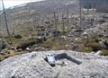 view gallery view galleryN24.8 km | TB 3904-4 Plechy in Czech Geodetic Points Trigonometrický bod na hore Plechý posted by: pavlikVB location: Jihočeský kraj, Czechia date approved: 05/06/2009 last visited: 08/21/2020 |
 view gallery view galleryE24.9 km | TB 5316-11 Multerberske pastviny in Czech Geodetic Points Trigonometrický bod u hranic s Rakouskem posted by: pavlikVB location: Jihočeský kraj, Czechia date approved: 04/28/2010 last visited: never |
|