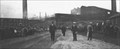
 view gallery view gallery E16.7 km E16.7 km
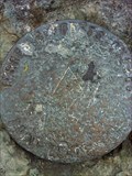
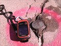
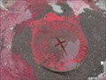
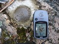
|   Plage Kiwanis 80K0431 Plage Kiwanis 80K0431
in Canadian Benchmarks Geodesic Benchmark point in Rouyn-Noranda posted by:  FrogMastr FrogMastr location: Québec, Canada date approved: 08/27/2012 last visited: 10/05/2012 |
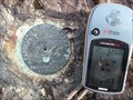
 view gallery view galleryE16.9 km | VRN-001 in Canadian Benchmarks Point géodésique situé au bout de l'ave. Wolfe à Rouyn-Noranda posted by: Garnotte13 location: Québec, Canada date approved: 10/15/2012 last visited: never |
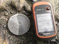
 view gallery view galleryE16.9 km | VRN-004 in Canadian Benchmarks Près d'une Station de Pompage sur le rue Iberville Ouest posted by: Garnotte13 location: Québec, Canada date approved: 10/19/2012 last visited: never |
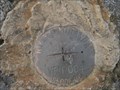
 view gallery view galleryE17.2 km | 78L201 Cathédrale St-Joseph, Rouyn-Noranda in Canadian Benchmarks Portail Est de la Cathédrale St-Joseph, Rouyn-Noranda, disque permanent. posted by:  bemarc bemarc location: Québec, Canada date approved: 05/22/2008 last visited: 07/31/2013 |
 view gallery view galleryE17.4 km | École Noranda in Canadian Benchmarks Derrière l'École Noranda posted by: Garnotte13 location: Québec, Canada date approved: 10/23/2012 last visited: never |
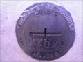
 view gallery view galleryE17.5 km | NDR 011 Palais de Justice in Canadian Benchmarks Poing Géodésique à Rouyn-Noranda posted by: Garnotte13 location: Québec, Canada date approved: 11/28/2012 last visited: never |
 view gallery view galleryE17.7 km | 93KZ020 Hotel de Ville in Canadian Benchmarks Hotel de Ville Rouyn-Noranda posted by: Garnotte13 location: Québec, Canada date approved: 09/25/2012 last visited: never |
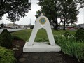 view gallery view galleryE17.9 km |  L'Arche de l'amitié - Rouyn-Noranda (Qc) Canada L'Arche de l'amitié - Rouyn-Noranda (Qc) Canada
in Lions Clubs International Markers l'Arche de l'Amitié du club des Lions situé sur l'autoroute 117 à Rouyn-Noranda (Qc) Canada - a Lions Friendship Arch located on highway 117 in the city of Rouyn-Noranda (Qc) Canada posted by: oiseau_ca location: Québec, Canada date approved: 08/16/2014 last visited: 06/26/2017 |
 view gallery view galleryE18.2 km |  Mine Noranda Mine Noranda
in Photos Then and Now L'entrée de la mine Noranda à Rouyn-Noranda. // Noranda mine entrance in Rouyn Noranda. posted by: Le Moog location: Québec, Canada date approved: 01/30/2006 last visited: 06/26/2017 |
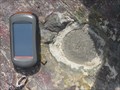
 view gallery view galleryE18.3 km | Éolienne in Canadian Benchmarks Point Géodésique Près de Éolienne de UQAT posted by: Garnotte13 location: Québec, Canada date approved: 10/11/2012 last visited: 07/24/2013 |
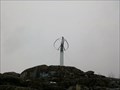 view gallery view galleryE18.5 km |  Éolienne du Cap d'Ours Éolienne du Cap d'Ours
in Windmills [FR] L’éolienne du Cap d’Ours est un aérogénérateur à axe vertical de 200 kW qui fut construit en 2004.
[EN] The Cap d'Ours vertical axis aeolian windmill was built in 2004 and can generate 200 kW of power. posted by: alynx location: Québec, Canada date approved: 05/04/2017 last visited: 06/26/2017 |
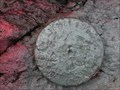
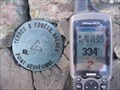
 view gallery view galleryE18.8 km | 79k0408 in Canadian Benchmarks Repère géodésique des Terres et Forets Québec. posted by: new8812 location: Québec, Canada date approved: 07/04/2011 last visited: 11/04/2013 |
 view gallery view galleryE19.3 km | Parc Terry Fox in Canadian Benchmarks Un point Géodésique situé sur cap de roche dans un parc de Rouyn-Noranda posted by: Garnotte13 location: Québec, Canada date approved: 10/11/2012 last visited: never |
 view gallery view galleryE20.6 km | Point Géodésique Terre & Forêt, Québec No 80 0484 in Canadian Benchmarks Point Géodésique posted by: Les Rois de pique location: Québec, Canada date approved: 09/07/2011 last visited: never |
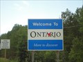 view gallery view gallery W20.8 km W20.8 km
|  Frontière Québec/ Ontario - Canada Frontière Québec/ Ontario - Canada
in Border Crossings un panneau signalant la frontière entre les provinces canadiennes du Québec et de l'Ontario, Canada - a border crossing sign between the canadian provinces of Quebec and Ontario, Canada posted by: oiseau_ca location: Québec, Canada date approved: 08/18/2014 last visited: 10/18/2017 |
 view gallery view gallery NE24.1 km NE24.1 km
|  Hub-Hub = (4821482) = N 48° 21.482 Alembert Hub-Hub = (4821482) = N 48° 21.482 Alembert
in Where's In A Name? Les collines D'Alembert, a cache hidden at 48° 21.490. Really nearby my place!
Pierre Goulet took the pictures. posted by: Hub-Hub location: Québec, Canada date approved: 10/16/2006 last visited: 07/07/2011 |
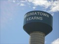 view gallery view galleryW25.4 km |  Virginiatown Water Tower - Virginiatown (Ontario) Canada Virginiatown Water Tower - Virginiatown (Ontario) Canada
in Water Towers a water tower located in the community of Virginiatown (Ontario) Canada posted by: oiseau_ca location: Ontario, Canada date approved: 08/16/2014 last visited: 10/03/2022 |
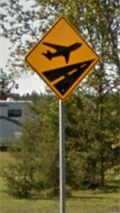 view gallery view galleryE32.5 km |  Survol des avions - Autoroute 117, Rouyn-Noranda, Québec Survol des avions - Autoroute 117, Rouyn-Noranda, Québec
in Uncommon Crossing Signs un panneau de signalisation représentant un avion situé sur l'autoroute 117 dans le nord du Québec - a plane crossing sign located on highway 117 in the north of Quebec posted by: oiseau_ca location: Québec, Canada date approved: 09/19/2014 last visited: 08/15/2023 |
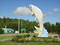 view gallery view galleryW36.4 km |  The Big Fish - Lake Larder (Ontario) Canada The Big Fish - Lake Larder (Ontario) Canada
in Figurative Public Sculpture a sculpture of a big fish located in the community of Larder Lake (Ontario) Canada posted by: oiseau_ca location: Ontario, Canada date approved: 08/18/2014 last visited: 10/03/2022 |
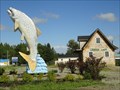 view gallery view galleryW36.4 km |  The Big Fish - Lake Larder (Ontario) Canada The Big Fish - Lake Larder (Ontario) Canada
in Roadside Attractions a big fish located in the community of Larder Lake (Ontario) Canada posted by: oiseau_ca location: Ontario, Canada date approved: 08/16/2014 last visited: 10/03/2022 |
 view gallery view gallery N39.1 km N39.1 km
| 79K6437 in Canadian Benchmarks Point géodésique situé à 137m au nord du rang de la lune, Municipalité de Rapide-Danseur, Abitibi-Ouest posted by: caius location: Québec, Canada date approved: 05/06/2009 last visited: 09/30/2012 |
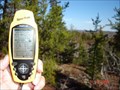
 view gallery view galleryN40.2 km | Benchmark Collines Destor in Canadian Benchmarks Station de triangulation de la commission de géodésie du Canada située au sommet des collines Destor dans le canton du même nom.
Triangulation station of geodesic survey of Canada located on top of Destor hill in the township of the same name. posted by: caius location: Québec, Canada date approved: 11/14/2009 last visited: never |
 view gallery view galleryE40.2 km | 95KSZ21 Côte Joannès in Canadian Benchmarks Transport Québec 95KSZ21 posted by: Garnotte13 location: Québec, Canada date approved: 09/25/2012 last visited: never |
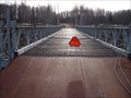
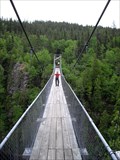 view gallery view galleryNE50.1 km |  Pont suspendu du Lac Lahaie - Abitibi, Qc, Canada Pont suspendu du Lac Lahaie - Abitibi, Qc, Canada
in Pedestrian Suspension Bridges The "Pont suspendu du Lac Lahaie" is a part of the hiking trails located in the "Parc d'Aiguebelle". posted by: tatie location: Québec, Canada date approved: 02/11/2012 last visited: 07/05/2013 |
 view gallery view galleryNE51.8 km |  Pont Bailey Parc Aiguebelle Pont Bailey Parc Aiguebelle
in Bailey Bridges Pont Bailey sur l'ancien tronçon de chemin de fer Taschereau - Rouyn.
Bailey bridge on the old section of railway Taschereau - Rouyn. posted by: caius location: Québec, Canada date approved: 11/17/2009 last visited: never |
|