 view gallery view gallery S21.4 km S21.4 km
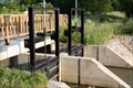
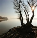
|   Sluice gate at the fish-ladders, river Ipoly Sluice gate at the fish-ladders, river Ipoly
in Historic Hand Operated Sluice Gates Sluice gate at the fish-ladders, river Ipoly posted by:  Nebel.com Nebel.com location: Pest, Hungary date approved: 06/19/2011 last visited: never |
 view gallery view gallery E22.2 km E22.2 km
|  Brick wayside shrine - Drégelypalánk, Hungary Brick wayside shrine - Drégelypalánk, Hungary
in Wayside shrines Brick wayside shrine on crossroad above the village Drégelypalánk. posted by:  Noe1 Noe1 location: Nógrád, Hungary date approved: 12/06/2016 last visited: never |
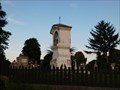
 view gallery view galleryE22.2 km |  Cemetery - Drégelypalánk, Hungary Cemetery - Drégelypalánk, Hungary
in Worldwide Cemeteries Cemetery of the north Hungarian village Drégelypalánk. posted by: Noe1 location: Nógrád, Hungary date approved: 12/06/2016 last visited: never |
 view gallery view gallery SE23.2 km SE23.2 km
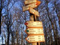
|  Csovanyos Peak, Hungary Csovanyos Peak, Hungary
in Direction and Distance Arrows Destination arrows at highest top of Borzsony. posted by: taska location: Hungary date approved: 11/30/2010 last visited: 07/21/2014 |
 view gallery view gallery NE27.4 km NE27.4 km
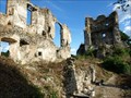
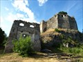
|  Ruins of castle Cabrad - Slovakia Ruins of castle Cabrad - Slovakia
in Preserved Architectural Remnants and Ruins Ruins of large castle, establised in 14. century. posted by: Noe1 location: Banskobystrický kraj, Slovakia date approved: 11/17/2013 last visited: 12/18/2017 |
 view gallery view galleryNE27.4 km |  Cabrad, Slovakia Cabrad, Slovakia
in Castles Ruins of large castle, establised in 14. century. posted by: Noe1 location: Banskobystrický kraj, Slovakia date approved: 11/17/2013 last visited: 12/18/2017 |
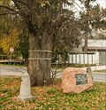
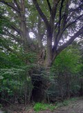 view gallery view gallerySE29.3 km |  Methuselah Oak (Nógrád) Methuselah Oak (Nógrád)
in Exceptional Trees This Pedunculate Oak located in the forest near Nógrád. posted by: BlackElders location: Nógrád, Hungary date approved: 07/28/2008 last visited: never |
 view gallery view gallery NW29.6 km NW29.6 km
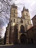
|  Monastery of Benedicts - Hronsky Benadik, Slovakia Monastery of Benedicts - Hronsky Benadik, Slovakia
in Roman Catholic Churches [EN]Monastery of Benedicts consist of fortified sacred buildings in Hronsky Benadik village.
[SK]Benediktinsky klastor v Hronskom Benadiku tvori subor opevnenych sakralnych stavieb v obci Hronsky Benadik.
posted by: crowak location: Banskobystrický kraj, Slovakia date approved: 11/29/2009 last visited: 12/18/2017 |
 view gallery view gallery N31.7 km N31.7 km
|  TIC - Sitno, Slovakia TIC - Sitno, Slovakia
in Tourist Information Centers - Visitor Centers Information Center of Protected Landscape Area - Štiavnica mountains - is located in historic lookout tower on summit of Sitno mountain, central Slovakia. posted by: Rikitan location: Banskobystrický kraj, Slovakia date approved: 06/15/2014 last visited: 08/06/2019 |
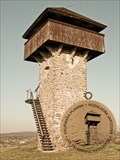
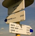
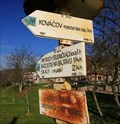
 view gallery view galleryNE32.7 km |  Vartovka guard tower - Krupina, Slovakia Vartovka guard tower - Krupina, Slovakia
in Exact Replicas Wooden carved copy of well known guard tower "Vartovka" built in 1564. Both can be visited in Krupina, small slovak town. Original on a top of the hill above town, replica in municipal park. posted by: Rikitan location: Banskobystrický kraj, Slovakia date approved: 10/27/2013 last visited: 03/16/2014 |
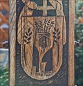 view gallery view galleryS33 km |  Carved CoA of village Chlaba - Chlaba, Slovakia Carved CoA of village Chlaba - Chlaba, Slovakia
in Coats of Arms Coat of Arms of village Chlaba can be seen on wooden column - millenium memorial standing on the square in the centre of the village. posted by: Rikitan location: Nitriansky kraj, Slovakia date approved: 12/04/2013 last visited: never |
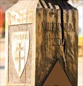 view gallery view galleryS33.2 km |  St.Stephen's column - Chlaba, Slovakia St.Stephen's column - Chlaba, Slovakia
in Made for the Millennium Millenium is special for Hungarians as it is 1000. anniversary of coronation of St.Stephen I., the first king of Hungary. Carved wooden millenium memorial stand in the centre of slovak village Chlaba, close to border with Hungary. posted by: Rikitan location: Nitriansky kraj, Slovakia date approved: 12/06/2013 last visited: never |
 view gallery view galleryS33.2 km |  Carved Millennium column - Chlaba, Slovakia. Carved Millennium column - Chlaba, Slovakia.
in Outside Wooden Display Carvings Carved wooden Millennium column in the centre of border-village Chlaba, south Slovakia. posted by: Rikitan location: Nitriansky kraj, Slovakia date approved: 12/03/2013 last visited: never |
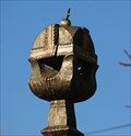
 view gallery view galleryNE33.2 km |  No. 557, Krupinska planina - rozhladna Vartovka, SK No. 557, Krupinska planina - rozhladna Vartovka, SK
in Tourist Stamps Photos Stamp no.577 - lookout tower Vartovka near town Krupina, Slovakia. This is former medieval guard tower, built in year 1564 as part of fortification against turkish attacks. Now serves as lookout tower for public. Free nonstop access. posted by: Rikitan location: Banskobystrický kraj, Slovakia date approved: 10/27/2013 last visited: 12/18/2017 |
 view gallery view galleryNE33.2 km | Vartovka - Krupina, Slovakia in Direction and Distance Arrows Hiking signage post with 2 direction & distance slats, installed on the top of the hill with Vartovka lookout tower, above town of Krupina, southern Slovakia. posted by: Rikitan location: Banskobystrický kraj, Slovakia date approved: 11/06/2013 last visited: never |
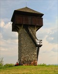 view gallery view galleryNE33.2 km |  Vartovka guard tower - Krupina, Slovakia Vartovka guard tower - Krupina, Slovakia
in Look-Out Towers Lookout tower "Vartovka" is 13-metres (43ft) high elegant tower, built in 1564 to protect medieval town of Krupina (central Slovakia) against Turkish attacks. It is preserved untill today as lookout tower for public. posted by: Rikitan location: Banskobystrický kraj, Slovakia date approved: 10/28/2013 last visited: 12/18/2017 |
 view gallery view galleryS33.2 km | Chlaba - Burda, Slovakia in Direction and Distance Arrows Hiking signage post with 2 direction & distance slats, situated in village Chlaba near border with Hungary, south Slovakia.
Arrows are part of large system of hiking signage in Slovakia, installed by Club of Slovak Tourists. posted by: Rikitan location: Nitriansky kraj, Slovakia date approved: 12/06/2013 last visited: 01/01/2014 |
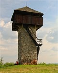 view gallery view galleryNE33.2 km |  Vartovka guard tower - Krupina, Slovakia Vartovka guard tower - Krupina, Slovakia
in Official Local Tourism Attractions Official attraction of town Krupina and its symbol - elegant guard tower Vartovka on the hill above the town is preserved to present times from year 1564. posted by: Rikitan location: Banskobystrický kraj, Slovakia date approved: 10/27/2013 last visited: 08/07/2012 |
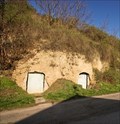 view gallery view galleryS33.2 km |  "Flood" cellars of Chlaba - south Slovakia "Flood" cellars of Chlaba - south Slovakia
in Earth Homes In 1838, when flood on Danube river flushed houses of village Chlaba away .. it settlers escaped to higher situated place above their village and hollowed their temporary homes directly into tuffs of mountain Burda. posted by: Rikitan location: Nitriansky kraj, Slovakia date approved: 12/09/2013 last visited: never |
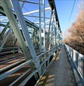 view gallery view galleryS34 km |  Sávoly-bridge between Szob, HUN and Chlaba, SVK Sávoly-bridge between Szob, HUN and Chlaba, SVK
in Truss Bridges Double-tracked railway- and border- bridge of Warren truss construction accross Ipel river between villages Szob (Hungary) and Chlaba (Slovakia). It is the 4th bridge at this place since 1850. posted by: Rikitan location: Nitriansky kraj, Slovakia date approved: 12/03/2013 last visited: 05/19/2017 |
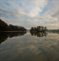 view gallery view galleryS34.3 km |  CONFLUENCE - Hron into Danube river - Sturovo, Slovakia CONFLUENCE - Hron into Danube river - Sturovo, Slovakia
in River Origins, Destinations and Confluences Confluence of Hron, second longest river (298kms) of Slovakia into Danube near town of Sturovo at border with Hungary. It is possible to drive here, but best is short walk from Sturovo. posted by: Rikitan location: Nitriansky kraj, Slovakia date approved: 12/05/2013 last visited: 04/26/2017 |
 view gallery view galleryN34.4 km | CYCLO M-5155C Nova Bana, Lidl - Slovakia in Direction and Distance Arrows Cycling signage post with 4 direction & distance slats, located in front of Lidl store in Nova Bana, central Slovakia. posted by: Rikitan location: Banskobystrický kraj, Slovakia date approved: 11/03/2013 last visited: never |
 view gallery view galleryS34.4 km | CONFLUENCE - Ipel into Danube river - Chlaba, Slovakia in River Origins, Destinations and Confluences Confluence of one of the major slovak rivers - Ipel into into wide waters of Danube - at slovak-hungarian border near villages of Chlaba (Slovakia) and Szob (Hungary). posted by: Rikitan location: Nitriansky kraj, Slovakia date approved: 12/04/2013 last visited: never |
 view gallery view galleryN34.6 km |  Dodekova lipa (linden) - Nova Bana, Slovakia Dodekova lipa (linden) - Nova Bana, Slovakia
in Dedicated Trees Linden tree in small slovak town Nova Bana is dedicated to first city mayor Karol Dodek (1867 - 1922). Tree is located in downtown, next to main street in front of Lidl store. posted by: Rikitan location: Banskobystrický kraj, Slovakia date approved: 11/05/2013 last visited: never |
 view gallery view galleryN34.6 km |  Banská Štiavnica, technical and natural monuments Banská Štiavnica, technical and natural monuments
in World Heritage Sites Location: Banska Stiavnica - old historic town centre with monuments and sights around.
Country: Slovakia posted by: Rikitan location: Banskobystrický kraj, Slovakia date approved: 11/19/2005 last visited: 03/27/2015 |
|