 view gallery view gallery N0.3 km N0.3 km
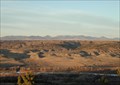
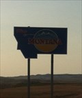
|   Fort Peck Reservation, Assiniboine & Sioux - Montana, USA Fort Peck Reservation, Assiniboine & Sioux - Montana, USA
in Nations Within Nations Assiniboine & Sioux - Nakoda posted by:  CerealBoxMonsters CerealBoxMonsters location: Montana date approved: 07/30/2009 last visited: 02/12/2013 |
 view gallery view gallery NE0.5 km NE0.5 km
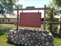
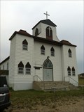
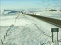
|  Fort Peck Indian Reservation - Poplar, MT Fort Peck Indian Reservation - Poplar, MT
in Montana Historical Markers A small sampling of history of the Assiniboines and Dakota tribes, and of Fort Peck Indian Reservation posted by: Bon Echo location: Montana date approved: 07/23/2018 last visited: never |
 view gallery view gallery W25.6 km W25.6 km
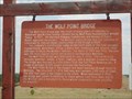
| The Lewis and Clark Bridge - Wolf Point (Montana) USA in Montana Historical Markers a historical sign placed near an abandoned truss bridge located on state highway 13 in the town of Wolf Point (Montana) USA posted by:  oiseau_ca oiseau_ca location: Montana date approved: 09/03/2014 last visited: 04/24/2023 |
 view gallery view galleryW25.6 km |  The Lewis and Clark Bridge - Wolf Point, Montana The Lewis and Clark Bridge - Wolf Point, Montana
in U.S. National Register of Historic Places an abandoned truss bridge located on state highway 13 near the town of Wolf Point, Montana, USA posted by: oiseau_ca location: Montana date approved: 11/26/2014 last visited: 04/24/2023 |
 view gallery view galleryW25.6 km |  The Lewis and Clark Bridge - Wolf Point (Montana) USA The Lewis and Clark Bridge - Wolf Point (Montana) USA
in Truss Bridges a truss bridge located on state highway 13 in the town of Wolf Point (Montana)USA posted by: oiseau_ca location: Montana date approved: 09/03/2014 last visited: 04/24/2023 |
 view gallery view galleryW25.6 km |  The Lewis and Clark Bridge - Wolf Point (Montana) USA The Lewis and Clark Bridge - Wolf Point (Montana) USA
in Orphaned Bridges an abandoned truss bridge located on state highway 13 in the town of Wolf Point (Montana)USA posted by: oiseau_ca location: Montana date approved: 09/04/2014 last visited: 04/24/2023 |
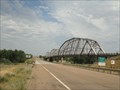 view gallery view galleryW25.6 km |  LONGEST truss bridge in Montana - Wolf Point (Montana) USA LONGEST truss bridge in Montana - Wolf Point (Montana) USA
in Superlatives an abandoned truss bridge located on state highway 13 in the town of Wolf Point (Montana) USA posted by: oiseau_ca location: Montana date approved: 09/04/2014 last visited: 04/24/2023 |
 view gallery view gallery SW37.7 km SW37.7 km
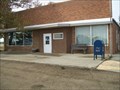
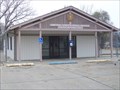
|  Vida, Montana 59274 Vida, Montana 59274
in U.S. Post Offices Post office in a very small town. posted by: NGComets location: Montana date approved: 11/01/2012 last visited: 06/09/2023 |
 view gallery view gallery NW39.6 km NW39.6 km
|  McDonalds South Web Camera - Scobey, MT McDonalds South Web Camera - Scobey, MT
in Web Cameras This is one of 73 (as of January 2017) Road Weather Information System camera sites operated by the Montana Department of Transportation to aid motorists as they make their way across BIG SKY Country. posted by: T0SHEA location: Montana date approved: 02/02/2017 last visited: never |
 view gallery view galleryNW39.6 km | McDonalds North Web Camera - Scobey, MT in Web Cameras This is one of 73 (as of January 2017) Road Weather Information System camera sites operated by the Montana Department of Transportation to aid motorists as they make their way across BIG SKY Country. posted by: T0SHEA location: Montana date approved: 02/02/2017 last visited: never |
 view gallery view gallery E52 km E52 km
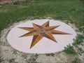
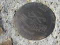
|  Corps of Discovery II - Culbertson, Montana Corps of Discovery II - Culbertson, Montana
in U.S. Benchmarks Corps of Discovery II – Culbertson, MT, is a four-inch Lewis and Clark commemorative disk located at the Culbertson Museum. posted by: seventhings location: Montana date approved: 11/26/2005 last visited: 04/03/2006 |
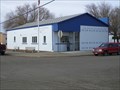
 view gallery view galleryE62.8 km |  First English Lutheran - Bainville, MT First English Lutheran - Bainville, MT
in Lutheran Churches First Lutheran Church in Bainville, MT. posted by: Islamorada location: Montana date approved: 06/07/2013 last visited: never |
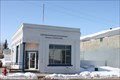
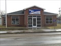
 view gallery view galleryW63.1 km | Frazer, Montana 59225 in U.S. Post Offices Small town post office. posted by: NGComets location: Montana date approved: 11/01/2012 last visited: 06/09/2023 |
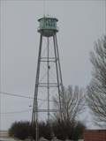
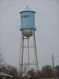 view gallery view galleryN77.1 km |  Scobey, MT Water Tower Scobey, MT Water Tower
in Water Towers Scobey, MT: City Water Tower
posted by: The Yoyo Man location: Montana date approved: 12/06/2008 last visited: never |
 view gallery view galleryN77.2 km | Flaxville, MT 59222 in U.S. Post Offices Tiny little building in rural town posted by: ZenPanda location: Montana date approved: 10/29/2014 last visited: 10/29/2014 |
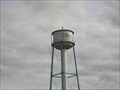
 view gallery view galleryN77.2 km | Flaxville, MT Water Tower in Water Towers Flaxville, MT: City Water Tower posted by: The Yoyo Man location: Montana date approved: 12/06/2008 last visited: never |
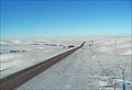
 view gallery view galleryN78.7 km | Navajo Web Camera - Redstone, MT in Web Cameras This is one of 73 (as of January 2017) Road Weather Information System camera sites operated by the Montana Department of Transportation to aid motorists as they make their way across BIG SKY Country. posted by: T0SHEA location: Montana date approved: 02/04/2017 last visited: never |
 view gallery view gallery S82.4 km S82.4 km
| Circle, Montana 59215 in U.S. Post Offices Small town post office. posted by: NGComets location: Montana date approved: 11/01/2012 last visited: 06/09/2023 |
 view gallery view galleryS82.6 km | Watertower, Circle, Montana in Water Towers Traditional watertower in a small town. posted by: NGComets location: Montana date approved: 11/01/2012 last visited: never |
 view gallery view galleryW83.8 km | Corps of Discovery II – Milk River, Fort Peck, MT in U.S. Benchmarks Corps of Discovery II – Milk River, Fort Peck, MT, is a 4-inch Lewis and Clark commemorative disk located at the Milk River Observation Point above the confluence of the Missouri and Milk Rivers near the Fort Peck Dam in MT. posted by: seventhings location: Montana date approved: 09/09/2006 last visited: 05/12/2007 |
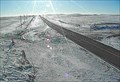
 view gallery view galleryE85.5 km | US 2 at State Line - Bainville, MT in Web Cameras This is one of 73 (as of February 2017) Road Weather Information System camera sites operated by the Montana Department of Transportation to aid motorists as they make their way across BIG SKY Country. posted by: T0SHEA location: Montana date approved: 02/11/2017 last visited: never |
 view gallery view galleryE85.9 km |  Montana/North Dakota Border Crossing along US 2 Montana/North Dakota Border Crossing along US 2
in Border Crossings Border crossing between Montana and North Dakota on Highway 2. posted by: Islamorada location: Montana date approved: 06/06/2013 last visited: 06/06/2013 |
 view gallery view galleryW86.4 km | ODB 15 - Fort Peck, Montana in U.S. Benchmarks Located on the Fort Peck Spillway posted by: Bon Echo location: Montana date approved: 07/26/2018 last visited: never |
 view gallery view galleryW86.4 km | Nashua, Montana 59248 in U.S. Post Offices Post office in a very small town. posted by: NGComets location: Montana date approved: 11/02/2012 last visited: 07/14/2018 |
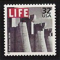 view gallery view galleryW86.6 km |  Spillway Gates, Fort Peck Dam Spillway Gates, Fort Peck Dam
in Philatelic Photographs A section of the spillway for the Fort Peck Dam in eastern Montana graced the cover of the first issue of LIFE magazine. The photograph was taken during construction of the dam in 1936. posted by: hykesj location: Montana date approved: 09/20/2013 last visited: never |
|