 view gallery view gallery NW1.4 km NW1.4 km
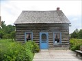
|  ") Maison Young - Pointe-à-la-Croix, Québec Maison Young - Pointe-à-la-Croix, Québec
in Histoire du Quebec (Quebec Historical Markers) La Maison Young, datant de 1830, est une maison construite en bois pièce sur pièce avec assemblage en queue d’aronde typique de l’architecture de la colonisation. Cette maison s’élevait auparavant à Escuminac. posted by:  Weathervane Weathervane location: Québec, Canada date approved: 05/20/2014 last visited: 12/14/2021 |
 view gallery view gallery SE1.9 km SE1.9 km
|  Restigouche Sam, Campbellton, New Brunswick Restigouche Sam, Campbellton, New Brunswick
in Roadside Attractions Restigouche Sam, the worlds largest atlantic salmon at 8.5 meters. posted by: JoMari location: New Brunswick, Canada date approved: 01/08/2011 last visited: 01/07/2024 |
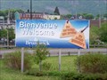 view gallery view gallerySE1.9 km |  Quebec/New Brunswick Border - Hwy 132 Quebec/New Brunswick Border - Hwy 132
in Border Crossings The border between New Brunswick and Quebec is on the bridge. The sign is as you exit the bridge. posted by:  GT.US GT.US location: New Brunswick, Canada date approved: 06/08/2010 last visited: 12/14/2021 |
 view gallery view gallerySE1.9 km |  Campbellton Lighthouse Hostel - Campbelton, New Brunswick Campbellton Lighthouse Hostel - Campbelton, New Brunswick
in Lighthouse Bed and Breakfasts Campbellton Lighthouse Hostel is lcoated in Campbelton, New Brunswick. posted by: tatie location: New Brunswick, Canada date approved: 10/18/2012 last visited: 01/07/2024 |
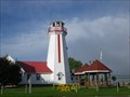
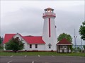 view gallery view gallerySE1.9 km |  Cambellton Lighthouse - New Brunswick, Canada Cambellton Lighthouse - New Brunswick, Canada
in Coastal Lighthouses The Campbellton Lighthouse is located on the Restigouche River and Baie des Chaleurs posted by: GT.US location: New Brunswick, Canada date approved: 06/07/2010 last visited: 01/07/2024 |
 view gallery view gallery W3.4 km W3.4 km
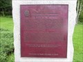
|  CNHS - Bataille-de-la-Ristigouche - Battle of the Restigouche - Pointe-à-la-Croix, Québec CNHS - Bataille-de-la-Ristigouche - Battle of the Restigouche - Pointe-à-la-Croix, Québec
in Canadian National Historic Sites Cette plaque décrit un Lieu historique national du Canada et est située sur la route 132, à Pointe-à-la-Croix. This plaque describes a Canadian National Historic Site and is located on Route 132, in Pointe-à-la-Croix. posted by: Weathervane location: Québec, Canada date approved: 09/04/2013 last visited: 10/07/2017 |
 view gallery view galleryW3.4 km |  Battle of the Restigouche - Pointe-à-la-Croix, Québec Battle of the Restigouche - Pointe-à-la-Croix, Québec
in UK Historical Markers In the spring of 1760, a small French squadron under Sieur de la Giraudais were completely defeated by a superior British squadron under Commodore the Honourable John Byron. posted by: Weathervane location: Québec, Canada date approved: 05/13/2022 last visited: 08/02/2022 |
 view gallery view gallery S3.5 km S3.5 km
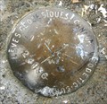
|  Geodetic Survey Benchmark 24136 Geodetic Survey Benchmark 24136
in Canadian Benchmarks Geodetic Survey Benchmark 24136 posted by: A Bound Crew location: New Brunswick, Canada date approved: 09/09/2009 last visited: 10/27/2013 |
 view gallery view galleryW3.7 km | LEGACY - Maison Busteed - Pointe-à-la-Croix, Québec in Histoire du Quebec (Quebec Historical Markers) La maison Busteed n'existe plus, ell a été détruite. The Busteed house no longer exist. It was destroyed / torn down. posted by: Weathervane location: Québec, Canada date approved: 05/20/2014 last visited: 10/26/2019 |
 view gallery view galleryW5.6 km |  Legacy - St-John United Church - Matapedia, Quebec Legacy - St-John United Church - Matapedia, Quebec
in Continental Reformed and Congregational Church Sites The former St-Joseph United Church, built in 1953, has recently been torn Down. posted by: Weathervane location: Québec, Canada date approved: 02/24/2019 last visited: 08/02/2022 |
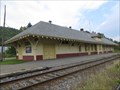 view gallery view galleryW19.2 km |  Gare de Matapédia - Matapédia Train Station - Matapédia , Québec Gare de Matapédia - Matapédia Train Station - Matapédia , Québec
in Train Stations/Depots La gare de Matapédia a été construite par le chemin de fer Intercolonial en 1903. Elle est située sur la rue Macdonell. The Matapedia train station was built in 1903 by the Intercolonial Railway Company. It is located on Macdonell Street. posted by: Weathervane location: Québec, Canada date approved: 05/19/2014 last visited: 08/02/2022 |
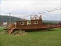 view gallery view galleryW19.5 km |  Scow (Chaland) - Matapédia, Québec Scow (Chaland) - Matapédia, Québec
in Landlocked Boats Ce « scowl» ou chaland est situé au coin du boulevard Perron (Route 132) et de la rue des Saumons, à Matapédia. This "scow" or barge is located at the corner of Perron Boulevard (Route 132) and Saumons (Salmon) Street, in Matapédia. posted by: Weathervane location: Québec, Canada date approved: 02/23/2019 last visited: 01/07/2024 |
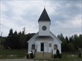
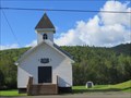
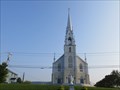
 view gallery view galleryW23.8 km |  Église Mann Settlement United Baptist - Matapédia, Québec Église Mann Settlement United Baptist - Matapédia, Québec
in This Old Church L'Église Mann Settlement United Baptist, érigée en 1911, est située sur le boulevard Perron Ouest, à Matapédia.The Mann Settlement United Baptist Church, erected in 1911, is located on Perron Boulevard West, in Matapedia. posted by: Weathervane location: Québec, Canada date approved: 12/26/2020 last visited: 05/13/2022 |
 view gallery view galleryW23.8 km | Église Mann Settlement United Baptist - Matapédia, Québec in Histoire du Quebec (Quebec Historical Markers) L'Église Mann Settlement United Baptist, érigée en 1911, est située sur la route 132, à Matapédia. posted by: Weathervane location: Québec, Canada date approved: 10/07/2013 last visited: 08/07/2020 |
 view gallery view gallery E24 km E24 km
|  Hamilton Monument - Dalhousie, NB Hamilton Monument - Dalhousie, NB
in Human Migration Monuments A 8.4 m tall painted Greek Revival stone block obelisk. posted by: AutisticMajor location: New Brunswick, Canada date approved: 08/26/2017 last visited: 09/28/2017 |
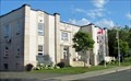 view gallery view galleryE24 km |  Dalhousie Town Hall - Dalhousie, NB Dalhousie Town Hall - Dalhousie, NB
in Art Deco - Art Nouveau A rare example of Art Deco architecture in New Brunswick. posted by: AutisticMajor location: New Brunswick, Canada date approved: 08/26/2017 last visited: 09/28/2017 |
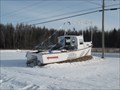 view gallery view galleryE25.4 km | La Source restaurant - Charlo, New Brunswick, Canada in Landlocked Boats A former fishing boat helping to announce a local restaurant. posted by: Mountain_Wanderer location: New Brunswick, Canada date approved: 12/21/2008 last visited: 04/29/2012 |
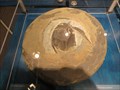 view gallery view galleryE27.2 km | Collection de poissons fossiles de Miguasha - Nouvelle, Québec in Histoire du Quebec (Quebec Historical Markers) La collection de poissons fossiles de Miguasha est située dans le parc national de Miguasha, Route de Miguasha Ouest, à Nouvelle, Québec. posted by: Weathervane location: Québec, Canada date approved: 09/16/2013 last visited: 12/14/2021 |
 view gallery view galleryE27.2 km |  Parc national de Miguasha - Miguasha National Park, Nouvelle, Québec Parc national de Miguasha - Miguasha National Park, Nouvelle, Québec
in World Heritage Sites Site fossilifère le plus exceptionnel du monde, le parc de Miguasha est située à Nouvelle, Québec. Considered to be the world's most outstanding illustration of the Devonian Period, Miguasha National Parc is located in Nouvelle, Québec. posted by: Weathervane location: Québec, Canada date approved: 09/15/2013 last visited: 12/14/2021 |
 view gallery view gallery SW30.3 km SW30.3 km
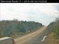
|  Route 17 Highway Webcam - Glenwood, NB Route 17 Highway Webcam - Glenwood, NB
in Web Cameras The province of New Brunswick operates a network of highway webcams throughout the province to aid motorists in avoiding blizzards, downpours and any other nasty phenomena Mother Nature may have up her sleeve. posted by: T0SHEA location: New Brunswick, Canada date approved: 05/11/2015 last visited: 11/10/2016 |
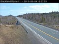 view gallery view galleryE34.1 km | Route 11 Highway Webcam - Blackland, NB in Web Cameras The province of New Brunswick operates a network of highway webcams throughout the province to aid motorists in avoiding blizzards, downpours and any other nasty phenomena Mother Nature may have up her sleeve. posted by: T0SHEA location: New Brunswick, Canada date approved: 05/11/2015 last visited: 09/02/2016 |
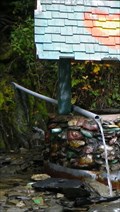 view gallery view galleryNW36.4 km |  La source de la Matapédia - Gaspésie, Québec, Canada La source de la Matapédia - Gaspésie, Québec, Canada
in Natural Springs La source de la Matapédia is located in Gaspésie, Québec, Canada. posted by: tatie location: Québec, Canada date approved: 02/25/2014 last visited: 08/07/2020 |
 view gallery view galleryNW36.4 km |  Pont de la Rivière Matapédia - Gaspésie, Québec, Canada Pont de la Rivière Matapédia - Gaspésie, Québec, Canada
in Arch Bridges Pont de la Rivière Matapédia is located in Gaspésie, Québec, Canada. posted by: tatie location: Québec, Canada date approved: 11/01/2012 last visited: 08/07/2020 |
 view gallery view galleryE36.5 km | Église de Saint-Omer - Carleton-sur-Mer, Québec in This Old Church L'Église de Saint-Omer, érigée en 1900, est située sur la route 132, à Carleton-sur-Mer (Saint-Omer). The church of Saint-Omer, erected in 1900, is located on Route 132, in Carleton-sur-Mer. posted by: Weathervane location: Québec, Canada date approved: 12/21/2020 last visited: never |
 view gallery view galleryE36.5 km | Église Saint-Omer - Carleton-sur-Mer, Québec in Histoire du Quebec (Quebec Historical Markers) L'Église de Saint-Omer, érigée en 1900, est située sur la route 132, à Carleton-sur-Mer (Saint-Omer). posted by: Weathervane location: Québec, Canada date approved: 10/07/2013 last visited: 09/21/2017 |
|